





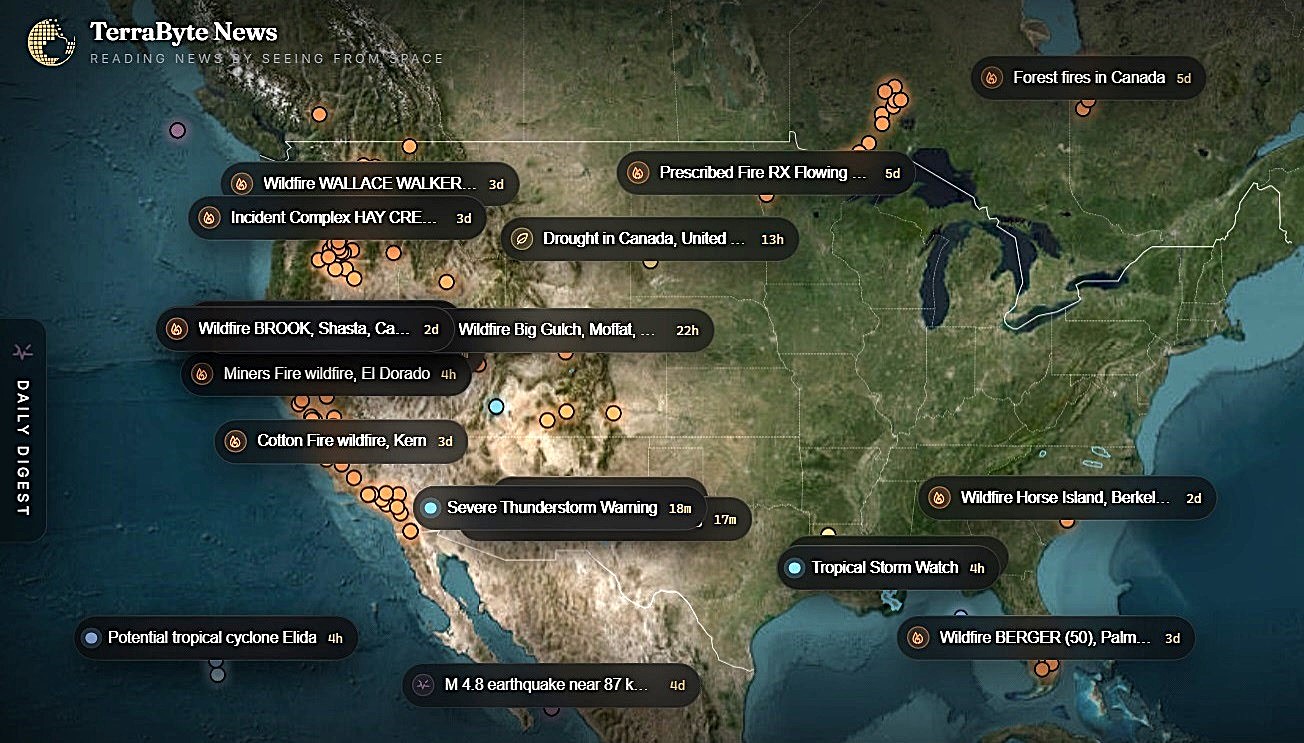
For generations, looking down at Earth from the heavens was a privilege reserved for a select handful of astronauts, high-level intelligence officers, and heavily funded scientific research conglomerates. Today, a quiet revolution is taking place that seeks to democratize this planetary perspective, turning the cold, distant view of satellite monitoring into an empathetic tool for everyday human survival and localized understanding. Merely two months after stepping out of stealth mode, Seattle and San Francisco-based startup TerraByte AI has introduced a series of powerful upgrades to its groundbreaking “Earth Search Engine,” aimed at giving ordinary citizens, local officials, and businesses an unprecedented, real-time look at our rapidly changing biosphere. Through its freshly launched TerraByte News service, the company has masterfully synthesized complex geographic data into an elegant, user-friendly interactive map that visually pinpoints severe weather occurrences, active wildfires, and seismic disruptions around the world. By marrying satellite photography with direct links to localized news reports, real-time social media dispatches, and emergency alerts, the platform bridges the vast emotional and cognitive gap between distant planetary phenomena and the deeply human, lived experiences of communities grappling with these immediate crises on the ground.
The operational magic of this system relies on a seamless blend of open-source public infrastructure and a newly forged commercial alliance with Texas-based space-tech platform SkyFi. In the past, trying to monitor an escalating natural disaster or analyze environmental shifts required navigating notoriously clunky, specialized academic databases to scrape low-resolution feeds from NASA’s Earth observation platforms or the European Space Agency’s Sentinel network. While these public-sector assets remain critical foundations of TerraByte’s mapping ecosystem, the newly announced partnership with SkyFi radically shifts the paradigm by giving users direct, affordable access to crystal-clear, high-resolution imagery compiled from more than 300 private orbital and aerial sensors. By driving down the cost of this elite orbital intelligence to as little as fifteen dollars per image, this partnership effectively dismantles the steep economic barriers that once gatekept high-fidelity satellite data from the public. Rather than waiting weeks for specialized bureaucratic clearances, a local conservationist, insurance adjuster, or small-farm owner can now purchase, hold, and utilize highly detailed tactical views of their specific region within twenty-four hours, transforming space-based observation into a fast, everyday routine.
This profound ease of access is the direct result of the personal and professional journeys of TerraByte’s visionary co-founders, CEO Rishi Madhok and Chief Technology Officer Fuxun Yu, who previously worked together analyzing geospatial data streams at Microsoft. Witnessing firsthand how the massive, non-stop deluge of daily satellite raw data overwhelmed traditional human processing systems, they realized that the key to unlocking this data lay in creating a radically simplified, conversation-driven user interface. They designed the Earth Search Engine around the foundational belief that interacting with planetary intelligence should be as intuitive and natural as typing a casual question into a search engine. By building advanced artificial intelligence networks that can seamlessly process natural language, parse vast geographical coordinates, and identify specific environmental patterns, they have shifted the user experience away from rigid coding syntax toward fluid, conversational dialogues. Whether an emergency coordinator searches for “forest fires in France” or a marine researcher queries a specific harbor, the underlying AI interprets the human intent, pulls up matching imagery, and delivers clear, contextual insights within seconds.
As TerraByte expands its specialized, close-knit team from three to five dedicated professionals, the market is responding with intense curiosity and rapid adoption across an incredibly diverse spectrum of human pursuits. The company is experiencing major commercial momentum from traditional industries, public agencies, and financial markets alike, proving that making the world searchable is an urgent economic and civic necessity. Insurance companies are actively employing the search engine to verify property damage safely and accelerate relief claims in the immediate wake of major storms, while emergency management agencies rely on it to optimize rescue logistics and keep responders out of harm’s way. At the same exact time, remote mining operations utilize the high-resolution views to minimize their environmental footprints, and quantitative hedge funds analyze ship traffic and industrial layouts to gain real-time, objective insights into global supply chains. For these various sectors, the ability to physically confirm remote ground conditions from the safety of an office translates to saved lives, reduced risks, and smarter, more ethical decision-making.
Expanding the boundaries of what search engines can do, TerraByte has also pioneered a sophisticated multimodal searching feature that relies on visual information rather than written language alone, recognizing that human sight is often our most immediate way of understanding a crisis. When a user is searching for something highly specific—such as a uniquely designed commercial vessel, an obscure agricultural layout, or a subtle anomaly hidden deep in a remote forest—they no longer have to struggle to craft a perfect, highly technical linguistic description. Instead, they can take a simple screenshot of the visual element they are looking for, upload it directly into the platform, and allow the machine-learning models to scan the global database for matching physical contours in a matter of seconds. This powerful, intuitive tool is already proving its worth in public safety and local conservation, as demonstrated in a recent demonstration showcasing how the platform effortlessly located a hidden shipwreck in the intricate waters of Washington state’s Possession Sound. By placing this high-order visual querying technology in the hands of the public, the platform transforms ordinary civilians from passive observers into active, analytical searchers who can monitor and protect their local environments.
Ultimately, the defining goal of TerraByte AI is to transcend the traditional limits of artificial intelligence by systematically weaving human collective wisdom and localized ground-truth facts back into its digital tapestry. Rishi Madhok and his team do not want their search engine to exist exclusively as a top-down, corporate diagnostic system; rather, they envision it evolving into a highly collaborative, crowdsourced platform where local residents can contribute their own first-person stories, real-time smartphone photos, and historical context. This deliberate integration of high-altitude machine scanning with on-the-ground human experiences creates a highly accurate, living history of our biosphere that is continuously updated and verified by the very communities who call these regions home. As our world transitions into an era of unpredictable climate shifts and rapid ecological transitions, tools like TerraByte’s Earth Search Engine serve as a powerful reminder that our best hope lies in matching technological innovation with deep, shared human empathy, enabling us to see our planet clearly, understand its vulnerabilities collectively, and act decisively to protect our shared future.