


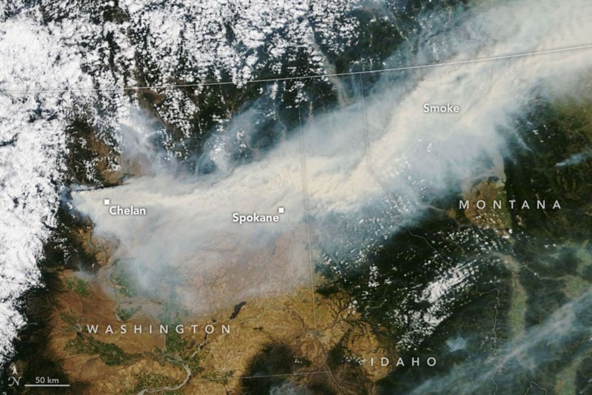
From the silent, cold vantage point of orbit, NASA’s satellites captured a hauntingly beautiful yet deeply tragic canvas: thick, bruised plumes of wildfire smoke carving a gray scar across the Pacific Northwest. Stretching from the dry, pine-scented hills of eastern Washington, this airborne river of ash drifted relentlessly northeast, smothering Idaho, blanketing Montana, and casting a somber, toxic haze over several Canadian provinces. On the ground, however, there was nothing beautiful about the view; it was the choking breath of a landscape in crisis, driven by a relentless cluster of blazes near Spokane—including the monstrous Old Trails, Fairview, and Autumn Lane fires—alongside the fierce Little Giant Fire further west near Chelan. In a matter of days, these combined infernos expanded from a threatening 5,400 acres to a ravenous 7,500-acre beast, devouring everything in their path. For the residents of Spokane and Stevens counties, the sky turned an apocalyptic orange, signaling a disaster that would change their lives forever. More than 700 structures, many of them cherished family homes built over generations, were swiftly reduced to smoldering foundations and chimneys standing like lonely sentinels in the ash. The suddenness of the onslaught forced an estimated 60,000 citizens to flee their neighborhoods, clutching whatever precious belongings, pets, and family heirlooms they could grab in a few chaotic moments, leaving behind the quiet safety of their everyday lives to join a massive, anxious exodus into the unknown. This satellite-level perspective, while scientifically invaluable, only hints at the profound human drama unfolding beneath the clouds, where local communities are left to grapple with the terrifying power of nature unleashed.
The sheer scale of this displacement is hard to comprehend until you look closer, moving from the macro-satellite view to the devastatingly intimate aerial photos captured by Nearmap, which document the swift erasure of entire communities. In June, these neighborhoods in Spokane County were vibrant, green sanctuaries, places where children played in lawn sprinklers, neighbors chatted over backyard fences, and summer gardens were just beginning to bloom under the gentle Pacific Northwest sun. By August, those same aerial grids revealed a stark, blackened wasteland, looking more like a war zone than a peaceful residential suburb. Entire blocks were completely erased, transformed into gray footprints of ash where cozy living rooms, busy kitchens, and decades of memories once stood. Yet, in a cruel twist of fate characteristic of modern wildfires, some houses stood entirely untouched, perfectly preserved right next to the charred remains of their neighbors’ lives. This stark contrast highlights the erratic, terrifying nature of these blazes, which leap from rooftop to rooftop driven by unpredictable winds, sparing one home while destroying another. For the thousands of evacuees waiting in temporary shelters, crowded hotels, or the spare bedrooms of kind strangers, looking at these maps is a grueling exercise in hope and dread, as they search for any sign of whether their personal sanctuaries survived or if they must now face the monumental, emotionally exhausting task of rebuilding their lives from literal dust.
As if the threat of encroaching flames were not enough, a silent, invisible poison has settled over the entire region, trapping millions of people inside their homes. The massive volume of smoke has severely degraded air quality across the Pacific Northwest, pushing pollution indices into the terrifying “Very Unhealthy” category in Spokane and Stevens counties. Agencies like the Washington Department of Ecology, the Colville Confederated Tribes, and the EPA have united with local clean air authorities to issue desperate Air Quality Alerts, warning of the insidious danger of PM2.5. These are not merely dusty particles; they are microscopic, airborne invaders measuring 2.5 micrometers or smaller—so incredibly tiny that they easily bypass the body’s natural defense mechanisms in the nose and throat, slipping deep into the lungs and entering the bloodstream. For healthy adults, inhaling this air feels like a constant, scratchy burn in the throat and a dull headache, but for vulnerable populations—such as young children whose lungs are still developing, pregnant women, the elderly, and those already battling asthma or cardiovascular diseases—it is a life-threatening hazard. Families are now living like submariners in their own neighborhoods, sealing their windows and doors with duct tape, running air purifiers on high, and keeping their children indoors, transforming their homes into makeshift bunkers against an atmosphere that has turned hostile to human breath, highlighting how the impact of wildfires extends far beyond the active burn zones.
This environmental emergency did not happen in a vacuum; it is the direct result of a perfect storm of meteorological extremes that turned the Washington wilderness into a highly volatile tinderbox. The atmospheric conditions leading up to the crisis were so severe that the National Weather Service took the unprecedented step of issuing Washington’s first-ever “particularly dangerous situation” fire weather alert on July 31, a rare and sobering designation reserved exclusively for life-threatening weather patterns. A persistent heatwave had baked the soil and sucked every drop of moisture from the grass, brush, and pine needles, turning the forest floor into a continuous carpet of highly flammable fuel. When combined with single-digit relative humidity and howling easterly winds gusting up to 38 miles per hour through geographic funnels like the Columbia River Gorge, the stage was set for explosive fire growth. These Red Flag conditions mean that a single spark from a dragging trailer chain, a hot vehicle exhaust pipe parked on dry grass, or a discarded cigarette can instantly ignite a fast-moving firestorm that outpaces any human effort to contain it. Firefighters find themselves battling not just the flames, but a shifting atmospheric monster that can change direction in an instant, turning safe staging areas into deadly traps and rendering traditional containment lines completely useless, forcing crews to constantly adapt their strategies under extreme physical and mental duress.
In the face of this overwhelming meteorological fury, local emergency management agencies have been working tirelessly to orchestrate one of the most complex evacuation efforts in the state’s recent history, utilizing a tiered warning system designed to keep citizens ahead of the fast-moving flames. Under Level 1 “Be Ready” alerts, residents packing emergency kits, organizing vital medications, and gathering important documents feel a mounting sense of anxiety, knowing the threat is on the horizon but unable to do anything but wait. This shifts to the tense, adrenaline-fueled state of Level 2 “Be Set,” where families load their vehicles, secure their pets, and stand by their front doors, watching the horizon turn increasingly dark with thick smoke. Finally, the terrifying Level 3 “Go Now” order leaves no room for hesitation; it is an immediate mandate to run for your life as emergency sirens wail and police officers drive down streets shouting instructions through bullhorns. Yet, amidst this terrifying chaos, the true strength of the human spirit has shone brightly through the gloom, demonstrating the power of community resilience. Neighbors who were strangers a week ago are now helping each other load heavy livestock into trailers, sharing precious N95 masks, and opening their properties to shelter displaced pets, while weary firefighting crews, working on little to no sleep, risk their lives on the front lines to defend homes they have never stepped foot in.
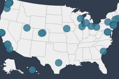
The tragic reality of the Spokane-area fires is that they are not an isolated incident, but rather a fierce symptom of a global crisis unfolding across the American landscape. According to American Forests’ active wildfire dashboard, more than 524 active wildfires have ravaged an astonishing 3.6 million acres across the United States this year alone, painting a sobering picture of our ecological future. While wildfires are an essential, natural component of forest rejuvenation, the human-induced impacts of climate change have disrupted these delicate ecological cycles, creating longer, hotter, and drier seasons that yield unnaturally severe and destructive conflagrations. In Washington, this vulnerability was compounded by a winter of critically low snowpack and a summer of relentless, record-breaking drought that left vegetation utterly defenseless against ignition. By early August, Washington had already suffered through more than 1,000 individual fires consuming over 425,000 acres, marking the state’s worst fire season since 2021, with twelve massive blazes still burning out of control. As we look at the smoke-covered satellite images of our planet, we are reminded of our shared vulnerability and our interconnectedness; these fires are a stark, collective call to action, demanding that we reevaluate our relationship with the land, support our vulnerable communities, and work together to heal a warming world before the ashes of today become the permanent reality of tomorrow.