






Deep within the frozen, unforgiving expanse of the Weddell Sea—a wild and windswept pocket of the Southern Ocean situated at the very bottom of our planet—human curiosity continues its age-old battle against the raw, majestic force of nature. Here, where the sub-zero water is a deep, bone-chilling steel grey and towering walls of ancient ice drift silently like ghost ships, a team of dedicated polar researchers from Germany’s Alfred Wegener Institute for Polar and Marine Research (AWI) embarked upon what would soon turn into an extraordinary polar expedition. Living and working aboard the legendary research icebreaker Polarstern, a massive, double-hulled vessel that serves as a floating sanctuary of warmth and high scientific endeavor amidst the chaotic polar elements, the crew worked tirelessly to peel back the layers of the Antarctic’s mysteries. Their initial and primary mission was not one of old-fashioned geographical conquest, but rather a modern, urgent scientific crusade: documenting and understanding the rapid, alarming decline of Antarctic sea ice, a stark and visible indicator of our rapidly warming global climate. Day after day, the scientists gathered data, analyzed ice cores, and tracked historical weather patterns, feeling the profound weight of their environmental stewardship in these delicate ecosystems. The atmosphere inside the ship was a warm, close-knit tapestry of intense focus, the steady hum of advanced sensory machinery, the clanking of steel against ice, and the quiet camaraderie of a crew utterly isolated from the rest of the civilized world, relying on steaming mugs of dry soup, shared stories, and determination to face the long polar shifts. Yet, as is so often the case in the volatile, unpredictable polar regions, the natural world was preparing to throw their scheduled plans into disarray, forcing them to pivot their focus from the modern crisis of melting ice to a hidden geographical relic of the earth’s ancient geological past that had remained completely hidden under the guise of an icy hazard.
The sudden, violent onset of a classic Antarctic storm put an abrupt pause to their scientific routine, as howling gales and towering waves began to pummel the icebreaker, reducing visibility to a blinding white haze and making open-water research temporarily impossible. Seeking safety from the merciless wind, freezing spray, and violent swell, the captain navigated the Polarstern toward the rugged, sheltering coast of Joinville Island, an established refuge where the vessel could safely anchor and wait out the worst of the weather. It was during this enforced, restless pause that Simon Dreutter, a highly skilled and observant bathymetry data engineer tasked with mapping the ocean floor, began analyzing their route on the ship’s digital navigation screens. He noticed a bizarre anomaly on the official nautical charts: a nearby zone vaguely flagged as an area with “unexplored dangers to navigation,” a mysterious warning with absolutely no background explanation or modern data to support its existence. Curious and slightly skeptical, Dreutter peered out of the foggy bridge window into the freezing, mist-shrouded distance, where his eyes locked onto what initially appeared to be a standard, run-of-the-mill iceberg drifting in the choppy grey waters. However, something about the shape and texture felt wrong to his trained eyes; the supposed block of ice looked unusually dark, weathered, and covered in grit—what he would later describe as a “dirty” iceberg. Grabbing a pair of binoculars for a closer look through the driving snow, a jolt of pure adrenaline shot through him as he realized they were not looking at ice at all, but rather at the jagged, ancient rock of a completely uncharted island. The excitement on the bridge became instantly infectious as Dreutter called over his colleagues, pointing wildly out into the freezing gloom at a piece of the earth that had somehow slipped through the cracks of modern human knowledge.
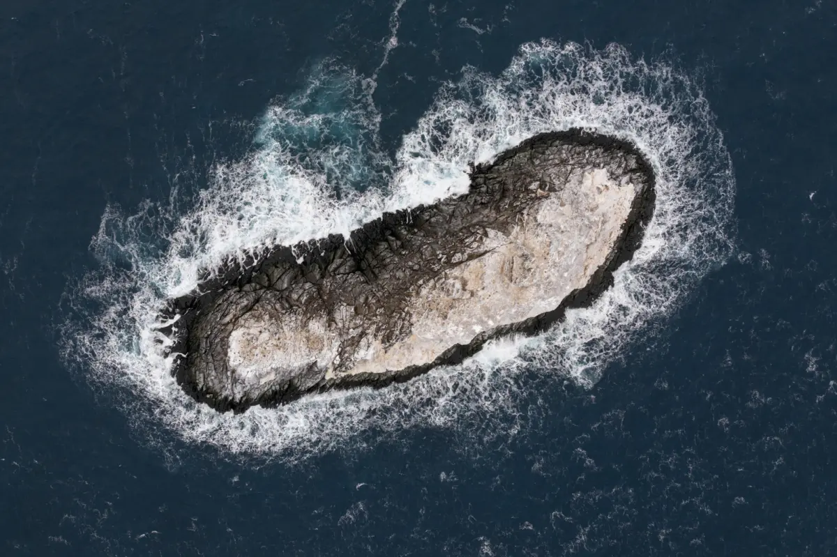
With the storm beginning to subside and curiosity overriding their original plans, the crew of the Polarstern carefully maneuvered the massive research vessel toward the mysterious, looming dark geographic feature rising from the sea, navigating with extreme caution through waters that had never been traversed by modern ships. They initiated a comprehensive survey of the newly discovered landmass, deploying state-of-the-art multibeam echo sounders to send acoustic pings down through the freezing water column, constructing a highly detailed, three-dimensional digital model of the surrounding seabed in real-time. To capture the island from above, the team launched a specialized drone that soared through the crisp polar air, capturing stunning, ultra-high-resolution aerial photographs that mapped every crevice, cliff, and contour of this newly discovered territory. The scientific measurements revealed a modest but undeniably significant landmass: a rocky island measuring roughly 426 feet in length and about 164 feet in width, protruding a dramatic 52 feet out of the freezing water. Up close, the island presented a stark, captivating contrast to its surroundings; while the nearby icebergs were constantly shifting, melting, and drifting with the whims of the ocean currents, this dark rock stood absolutely resolute, an ancient geological anchor enduring the relentless, icy pounding of the Southern Ocean. For the scientific team standing on the cold, wind-swept deck of the Polarstern, wrapped in heavy orange parkas and breathing in the crisp, salt-crusted air, the moment was deeply humbling and profoundly exciting. They watched the drone return to its pad and listened to the steady hum of the sonar equipment, fully realizing that they were the very first human beings to ever officially measure, photograph, and document this tiny, isolated corner of our world, transforming a mysterious abstract hazard on a map into a tangible, physical reality.
Following their successful survey, the researchers began to unravel the mystery of why this solid, permanent geographical feature had been completely misidentified and marked as nothing more than a generic “danger zone” for so many decades. According to representatives from the Alfred Wegener Institute, the sea floor surrounding the newly discovered island is incredibly treacherous, characterized by erratic, rolling, and ancient “hummocky mounds” and rocky underwater shoals where the water depths can change abruptly and violently over very short physical distances. For early maritime explorers and historical cartographers, these shallow, uncharted waters presented an invisible deathtrap, likely leading them to designate the entire region as a hazardous zone on their paper maps to keep vessels far away, rather than risking a closer approach to identify the rock. This deep historical isolation and neglect was further compounded by the limitations of modern satellite technology, which many people mistakenly assume provides an absolute, flawless, high-definition view of every square inch of our planet. In reality, most polar satellite observations are modeled at relatively low resolutions, making it incredibly difficult to distinguish a small, snow-dusted rock from the millions of flat-topped icebergs that clog the nearshore waters of Antarctica. Consequently, these shallow coastal waters remain what cartographers refer to as “white spots” or data gaps on nautical charts—blind spots where satellite eyes fail, and only physical, direct exploration can reveal the truth. This revelation serves as a vivid, eye-opening reminder of the limits of our digital technology, illustrating how easily a permanent piece of our physical geography can be completely lost in translation when we rely solely on remote data rather than the courage of humans physically sailing into the dark, uncharted corners of the world.
Now that this quiet, dramatic sentinel of the Weddell Sea has finally been brought to light, it must eventually undergo the deeply human, ancient ritual of being officially named, transitioning from an anonymous coordinate to a permanently recognized milestone on the global map. The discovery team is currently preparing a formal, highly detailed naming proposal, which will be submitted to the Scientific Committee on Antarctic Research (SCAR)—the international body responsible for reviewing, coordinating, and approving geographical names in this frozen territory. The act of naming is a profound human necessity; it is how we make sense of the vast, chaotic wilderness, transforming the unfamiliar and threatening into something we can understand, discuss, and respect. Historically, Antarctic features were named after legendary explorers, physical shapes, or the nations that funded the expeditions, but in the highly collaborative modern scientific era, they often tend to honor the collective effort of research teams, technological vessels, or the natural phenomena that led to their discovery. As the crew of the Polarstern drafts their proposal, one cannot help but wonder what name they will choose—perhaps something commemorating the fierce storm that drove them to shelter, the loyal research vessel that carried them, or Simon Dreutter, the eagle-eyed scientist who looked out the window at the perfect moment. This administrative process, while seemingly dry on paper, carries a beautiful weight of historical continuity, directly linking the high-tech, fleece-clad scientists of today with the legendary wooden-ship explorers of the heroic age of Antarctic exploration. By submitting this name, these modern researchers are leaving their own permanent, meaningful footprint on the canvas of human history, proving that the map of our world is still a living, breathing document.
In an era dominated by global positioning systems, ubiquitous satellite imagery, and the comforting but false illusion that every corner of our planet has been thoroughly mapped, categorized, and conquered, this remarkable discovery is a powerful, humbling reminder of how much of our own world remains a beautiful, completely wild, and untamed mystery. According to polar officials, less than a quarter of the vast, ice-choked Weddell Sea has been fully and accurately mapped, leaving the vast majority of this frigid, deep marine environment as an unexplored frontier waiting for future generations of scientists to discover. The spokesperson for the Alfred Wegener Institute noted that while finding a new island is an incredibly rare, electrifying event in the modern age, the sheer lack of seafloor data means there is still an immense, untapped scope for uncovering secret trenches, underwater volcanoes, and vast mountain ranges on the seabed below. This realization injects a powerful sense of wonder, romance, and hope into the hearts of the global scientific community, particularly for researchers who spend most of their difficult careers documenting the bleak, distressing realities of climate change and environmental degradation. It shows that even in our darkest times, the Earth still holds profound secrets, offering moments of pure, childlike joy and discovery to those who are willing to look closely, brave the bitter cold, and challenge the status quo. Ultimately, this newly mapped island is far more than just a tiny, fifty-two-foot mound of dark rock in the Southern Ocean; it is a beautiful, living symbol of relentless human curiosity and scientific humility. It stands as an inspiring beacon for the future, reminding us all that we are still pioneers at heart, and that as long as we maintain the courage to venture into the fog, there will always be new horizons to find.