


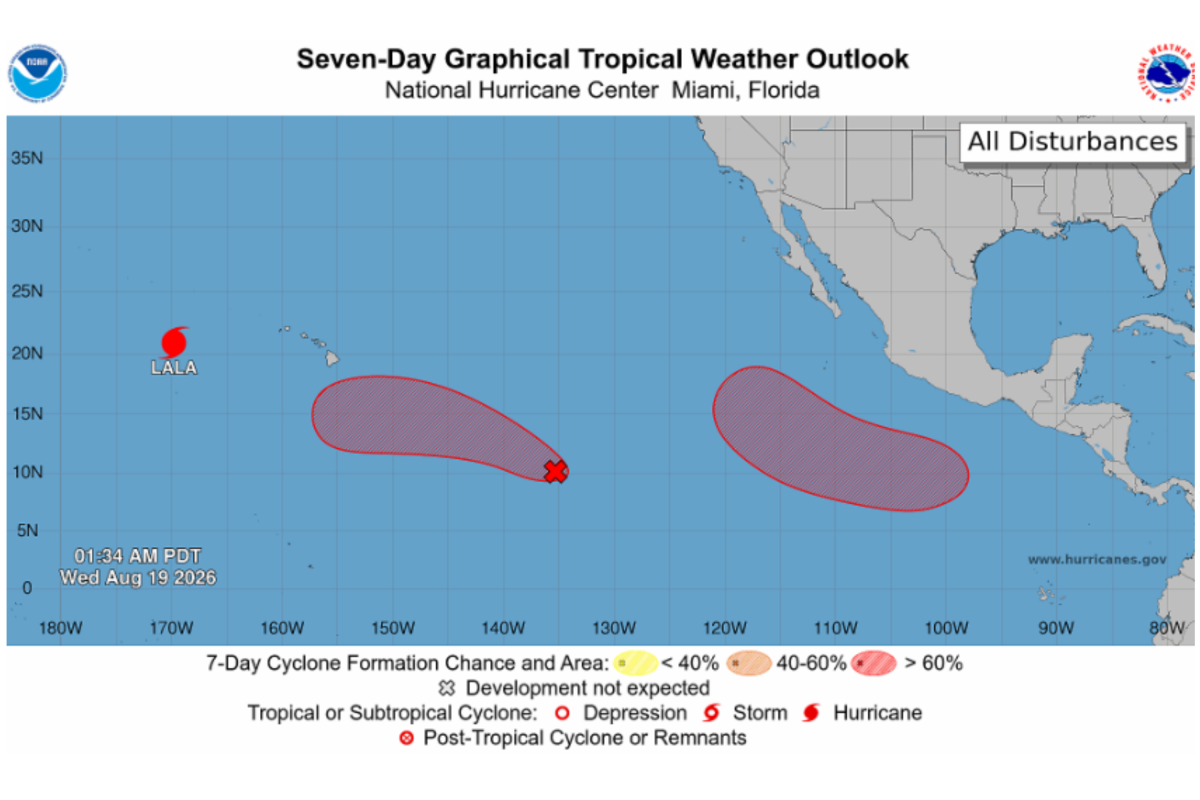
Just days after Hurricane Lala tore through Hawaii with destructive flooding, damaging winds, and sweeping power outages, forecasters are already watching two new disturbances in the Pacific Ocean. For residents in the islands, the timing is anything but comforting. Hawaii is still in the early stages of cleaning up, drying out, and repairing what the storm broke, and now there’s a reminder that hurricane season doesn’t pause for human exhaustion. The National Hurricane Center issued its latest Tropical Weather Outlook late Tuesday night, and the message was clear: the ocean is still restless. Two separate areas of low pressure are showing increasing signs of organization, and both have the potential to develop into more serious systems in the coming days. One is expected to take shape several hundred miles south-southwest of the coast of southern Mexico later this week. The other sits east-southeast of Hawaii, closer to home for a state that hasn’t had time to recover from Lala’s blow. Neither system is an immediate threat to land, and forecasters are careful to say that, but the psychology of hurricane season is different when the water is warm, the season is peaking, and everyone is still jumpy from the last storm. This is the time of year when the tropics start to wake up in earnest, and the NHC’s outlook reflects that. It’s not a panic, but it’s a watchfulness. The same forecasters who spent the weekend tracking Lala are now turning their attention to a broader, more complex weather picture, trying to figure out which of these swirling areas of thunderstorms might become the next named storm. For now, the systems are just disturbances, but in the Pacific, that can change quickly.
The first of the two areas being monitored is expected to develop south-southwest of Mexico, and while it carries a very low chance of formation in the next couple of days, the longer-range outlook is much more significant. According to the National Hurricane Center, this disturbance could become a tropical depression over the weekend as it moves west-northwestward over the open ocean. A tropical depression is the earliest official stage of a tropical cyclone, the step before it grows into a tropical storm and eventually a hurricane. Forecasters are currently putting the odds of development over the next seven days at about 80 percent, which is a high number by any standard. But what does that actually mean for people? Not much, at least not yet. The system is forecast to stay offshore, churning over warm tropical waters far from coastlines. It’s the kind of storm that could become a weather headline, but not necessarily a disaster story. Still, forecasters are paying close attention because the eastern Pacific has a history of producing late-season surprises, and a system that looks harmless today can quickly strengthen into a powerful hurricane when conditions are right. There’s something almost hypnotic about watching these patterns on satellite imagery, the swirl of clouds and moisture spinning across an endless blue ocean, but for people who live in vulnerable coastal communities, that same imagery carries a more anxious weight. The forecast models are still uncertain about the exact track and intensity, and forecasting is always a game of probabilities rather than certainties. The National Hurricane Center’s job is to alert the public without causing panic, and so far, they’re emphasizing that this system poses no immediate threat to land. It’s a reminder, though, that the hurricane season doesn’t end because one storm has passed. The ocean is still warm, the atmosphere is still energetic, and the machinery that creates these powerful weather systems is still running.
The second system is the one that might feel more personal, because it’s closer to Hawaii, a state already reeling from Hurricane Lala’s impact. This tropical wave, located east-southeast of the Hawaiian Islands, has shown some signs of organization, which is a technical way of saying that thunderstorms and circulation are beginning to cluster around a developing center rather than staying scattered and weak. The National Hurricane Center said conditions appear favorable for development, and it would not be surprising to see a tropical depression form within a few days as the system moves westward into the Central Pacific. The numbers here are notable: forecasters are giving it a 50 percent chance of formation within the next 48 hours and an 80 percent chance over the next seven days. That’s a rapid timeline, and for a state that just lived through a hurricane, the news can be unsettling. But it’s important to remember that not every tropical depression becomes a devastating hurricane, and many systems weaken or turn away before they ever threaten populated islands. Still, the people of Hawaii know better than most that a storm doesn’t have to make official landfall to leave a mark. Lala proved that. The psychological toll of watching another disturbance approach so soon after a disaster is real, and forecasters are aware that their words carry extra weight in the aftermath of a storm. They are trying to be honest about the uncertainty while also reassuring the public that there is time to prepare, time to watch, and time to hope that this one fizzles out over the open ocean. The fact that the system is still far from land offers some breathing room, but in the Pacific, distances can shrink quickly when a storm is moving.
Hawaii’s recovery from Hurricane Lala is only just beginning, and the damage is substantial. Lala passed just south of the Big Island over the weekend as a Category 1 hurricane, and although the center of the storm remained offshore and never technically made landfall, its eyewall brushed the island with hurricane-force winds and historic rainfall. That distinction, official landfall versus not, mattered little to the communities that bore the brunt of the storm. Widespread flooding turned roads into rivers, bridges were damaged or washed out, and entire neighborhoods were temporarily isolated by water and mudslides. More than a hundred homes were damaged or destroyed, according to officials, and tens of thousands of customers lost electricity across the islands, with some rural areas facing an extended wait for lights to come back on. One death has been linked to the storm, a 90-year-old woman whose body was found in the hard-hit Naalehu area, a heartbreaking reminder that behind every statistic is a human story. In some locations, rainfall totals exceeded 40 inches, an almost incomprehensible amount of water that transformed normally dry streambeds into raging torrents and turned hillsides into hazards. The communities of Naalehu, Pahala, and Waiohinu were among the hardest hit, and Governor Josh Green said the flooding, mud, and debris flows caused the most damage there. “These communities have a lot of cleanup to do and they’re going to need a lot of support,” he said. It’s the kind of statement that sounds simple but carries a heavy meaning: roads need rebuilding, homes need repairing, and people need help carrying the emotional and financial burden of losing so much in such a short time. Recovery is slow, exhausting work, especially when the weather is hot, the power is still out in places, and the threat of another storm lingers in the forecast.
What happens next is still uncertain, but the forecast is worth taking seriously. Hurricane Lala itself, after weakening, re-intensified into a Category 4 hurricane on Tuesday night, with maximum sustained winds of 130 miles per hour, and is now moving further west across the Pacific Ocean. The National Hurricane Center has warned that hurricane conditions could affect parts of the Papahānaumokuākea Marine National Monument, including Lisianski Island and Maro Reef, as the storm continues its journey. That may seem remote, and it is, but those waters are important, fragile ecosystems, and the storm’s passage is another reminder of how connected all parts of the Pacific are. Meanwhile, attention is shifting to the two new disturbances, both with 80 percent chances of development over the next seven days. Meteorologists are pointing out that the eastern and central Pacific hurricane basins remain highly active, and the relatively quiet moments between storms are not the same as the season winding down. For people in Hawaii, Mexico, and anywhere else in the path of these systems, the message is to stay informed, but not to spiral into fear. Preparedness is a process, not a panic. It means checking emergency supplies, reviewing evacuation routes, and paying attention to official forecasts rather than rumors or dramatic social media posts. It means accepting that hurricanes are part of life in the Pacific and that communities can be resilient while still taking every storm seriously. The ocean has no memory of what it has already done this season, and it has no sense of fairness. It simply continues to heat, evaporate, swirl, and release energy in ways that are both beautiful and terrifying. For forecasters, the work is about understanding those forces well enough to give people a warning, a little time, and a chance to protect what matters most. For residents in the affected regions, it’s about finding that balance between vigilance and normal life, between watching the sky and trusting that the community will come together if the worst happens again.