






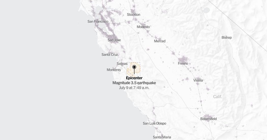
Shaken but Unscathed: Minor Magnitude 3.5 Earthquake Rattles Central California Near Pinnacles National Park
A Morning Wake-Up Call in San Benito County
Residents of Central California experienced a sudden, brief disturbance on Thursday morning when a minor magnitude 3.5 earthquake rattled the rugged terrain of San Benito County. According to official seismic data recorded by the United States Geological Survey (USGS), the moderate temblor struck precisely at 7:51 a.m. Pacific Time. The epicenter of the quake was located approximately 9 miles northwest of Pinnacles, California—a region famously known for its striking volcanic rock formations, sprawling wilderness, and proximity to the highly active San Andreas Fault system. Although the early morning seismic event occurred at a shallow depth, which often intensifies the localized sensation of shaking, there were no immediate reports of structural damage, injuries, or significant disruptions to daily commerce in the rural communities surrounding the epicenter.
The Science of the Shake: Understanding the Fault Lines
While a magnitude 3.5 earthquake is globally categorized as minor, it serves as a potent reminder of the complex subterranean forces constantly reshaping the Golden State. Seismologists at the USGS noted that the tremor generated a peak shake intensity of 3 or greater on the Modified Mercalli Intensity Scale. In scientific terms, an class-3 intensity is defined as “weak” shaking, often described by those who experience it as similar to the vibration of a heavy truck passing by a residence. Despite this mild classification, the physical geography of Central California—characterized by highly compressed sedimentary layers and a dense web of fault lines—means that even minor tremors can be felt across a surprisingly wide geographical footprint, extending well beyond the immediate epicenter into neighboring valleys and agricultural towns. As is standard practice following any notable seismic activity, geophysicists are continuing to review real-time telemetry data. As more field reports and sensor readings arrive, the USGS may slightly adjust the reported magnitude or update its shake-severity mapping to paint a more precise picture of how the energy waves traveled through the regional crust.
SEISMIC PROFILE: PINNACLES DISTRICT
Date/Time: Thursday, 7:51 AM Pacific
Epicenter: 9 Miles NW of Pinnacles, CA
Magnitude: 3.5 (Subject to USGS Revision)
Depth: Shallow Crustal (~4.2 miles)
Shake Intensity: III (Weak) on Mercalli Scale
Primary Fault: San Andreas Fault Zone System
Aftershocks and the Dynamic Adjustments of the Earth
In the hours following the initial morning quake, sensitive regional monitoring stations detected a series of smaller, subsequent tremors in the same geographical sector. Scientists identify these secondary events as classic aftershocks, which are standard physical adjustments occurring along the specific segment of the fault plane that slipped during the initial fracture. The USGS emphasizes that aftershocks are not indicative of an failure in seismic forecasting, but are rather the natural, mechanical process of the Earth’s crust resolving residual stress to find a new state of equilibrium. These secondary micro-quakes can persist for days, weeks, or in some instances, even years after an initial disturbance. While most aftershocks are notably smaller than the mainshock, there remains a statistically small but significant probability that a subsequent event could equal or exceed the magnitude of the original earthquake, presenting a continuous, underlying hazard to older, already weakened brick-and-mortar structures in the vicinity.
Mapping the Impact: Population, Topography, and Community Response
The region surrounding the epicenter, particularly near Pinnacles National Park, is characterized by a low population density, comprised mostly of historic ranching properties, agricultural fields, and protected ecological wilderness. Population density data provided by LandScan via the Oak Ridge National Laboratory confirms that the sparse layout of San Benito and Monterey counties significantly mitigated the potential risks of this earthquake. Park rangers at Pinnacles National Park reported that hiking trails, campsites, and visitor centers remained fully operational, with no rockfalls or trail structural failures detected. For the locals living in nearby municipal hubs like Hollister, Salinas, and Soledad, the morning shake was largely treated as a routine aspect of living in one of the most seismically active zones in North America, prompting quick discussions on social media platforms but requiring no emergency interventions.
REGIONAL SEISMIC HISTORY & ACTIVITY INDEX
(Earthquakes within 100 Miles / Past 7 Days)
Magnitude Range Number of Events General Community Perception
M 1.0 – M 2.0 [||||||||||||] 14 Detected only by instruments
M 2.1 – M 3.0 [|||||] 6 Barely felt by awake residents
M 3.1 – M 4.0 [|] 1 Felt indoors; hanging objects swing
M 4.1+ [ ] 0 Moderate shaking; minor damage risk
Living in Earthquake Country: The Importance of Continuous Preparedness
Although the Thursday morning tremor did not result in a major disaster, emergency management officials are utilizing the event as a timely teaching moment for public safety and preparedness. The California Governor’s Office of Emergency Services (Cal OES) points out that minor events are invaluable reminders for households to review their personal emergency plans, secure heavy furniture, and ensure emergency kits are stocked with fresh water, non-perishable food, and medical supplies. In a state traversed by major fault lines like the San Andreas, Hayward, and Calaveras, seismic safety is an ongoing lifestyle requirement. State geologists warn that while minor earthquakes release localized crustal stress, they do not prevent or significantly delay the occurrence of a future major earthquake, reinforcing the constant need for community safety drills and robust structural building codes.
Advanced Monitoring: The Technology Behind Modern Seismology
The rapid dissemination of information following the Pinnacles earthquake highlights the incredible advancements made in modern geophysical monitoring over the past decade. By utilizing a highly integrated network of broadband seismometers, GPS receivers, and satellite-based radar, organizations like the USGS, the Berkeley Seismological Laboratory, and Caltech can pinpoint the epicenter, depth, and fault alignment of a quake within seconds of its occurrence. Furthermore, the implementation of ShakeAlert—California’s cell-phone-based early warning system—saves critical seconds by sending push alerts to residents before the secondary, more destructive seismic waves reach their location. As researchers continue to analyze the telemetry from Thursday’s event, the data gathered will be integrated into larger regional tectonic models, helping engineers design safer infrastructure and helping scientists better understand the unpredictable, slumbering giant beneath the California landscape.