






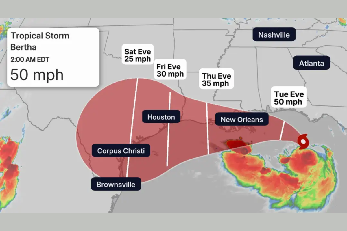
The warm, heavy air of the Gulf of Mexico has begun to carry a familiar, tense charge as residents along the northern Gulf Coast prepare for the arrival of Tropical Storm Bertha, the second named system of the 2026 Atlantic hurricane season. For the families, business owners, and fishermen who call this vulnerable stretch of coastline home—spanning from the sandy shores of the Florida Panhandle across the historic coastal towns of Alabama and Mississippi to the low-lying bayous of southeastern Louisiana—the sudden shift in the weather serves as a stark reminder of the fragile relationship they share with the sea. On Monday night, the drone of Hurricane Hunter aircraft cutting through the dark, cloud-choked sky confirmed what many had already feared: Tropical Depression Two had officially gathered enough strength over the warm, bath-like waters of the northeastern Gulf to be upgraded to a tropical storm. Moving at an agonizingly sluggish pace of just two miles per hour toward the northwest, Bertha was last located about 125 miles south of Panama City, Florida, carrying maximum sustained winds of 50 miles per hour. This slow, deliberate crawl is perhaps the most psychological and physically challenging aspect of the storm for coastal populations; it means the system will linger just offshore for days, churning the ocean, saturating the air with moisture, and giving residents a painfully long window to watch the horizon, check their emergency kits, and wonder exactly where the center of this unpredictable storm will ultimately make landfall.
The projected path of Tropical Storm Bertha suggests a prolonged encounter with land, as forecasters expect the system to drift lazily along or near the northern Gulf Coast well into the upcoming week. According to the National Hurricane Center in Miami, the storm’s center is anticipated to draw close to southeastern Louisiana by late Wednesday before tracking slowly westward along the coast. The science behind Bertha’s sluggishness reveals a fascinating, albeit frustrating, atmospheric chess match playing out miles above the Earth’s surface. Meteorologists point out that the storm is currently battling a hostile environment characterized by dry air intrusion and significant wind shear—phenomena that act as natural inhibitors to rapid intensification. Alex DaSilva, a lead hurricane expert with AccuWeather, explained that these factors will be the ultimate arbiters of Bertha’s structure, noting that dry air and disruptive wind shear are actively preventing the storm from organizing into a more dangerous, tightly wound hurricane. This atmospheric friction is a double-edged sword for those in its path; while it keeps the storm from manifesting the catastrophic, infrastructure-shattering winds of a major hurricane, it also dooms the region to a protracted, slow-motion event where a disorganized but incredibly wet storm system sits over the same coastal communities for days on end, refusing to be pushed away by shifting steering currents.
Because Bertha is moving so slowly, water—rather than wind—has quickly emerged as the most significant and potentially life-threatening hazard associated with the storm. The National Hurricane Center has issued a stern Storm Surge Watch stretching all the way from the Alabama-Florida border westward to the mouth of the Mississippi River, warning of “life-threatening inundation” as the storm’s persistent winds push vast amounts of seawater onto dry land. Experts warn that if the peak storm surge coincides with high tide, coastal communities could see water levels rise by two to four feet, drowning docks, flooding low-lying coastal highways, and creeping into vulnerable waterfront properties. This hazard is compounded by a tremendous amount of tropical rainfall that Bertha is funneling directly from the warm depths of the Gulf. Widespread rainfall totals of two to four inches are projected from western Florida all the way to eastern Texas, with isolated pockets of up to eight inches threatening to overwhelm local drainage systems. For historic, low-lying cities like New Orleans, where pumping stations constantly battle the laws of physics, and for rural coastal parishes where the water table is already high, this combination of relentless rain and coastal surge raises the very real specter of flash flooding, turning roads into impassable rivers and forcing residents to rethink their daily commutes and safety plans.
Beyond the aquatic threat, the outer bands of Tropical Storm Bertha carry atmospheric instability that could trigger sudden, localized disasters in the form of isolated tornadoes and tropical-storm-force winds. The National Hurricane Center has established Tropical Storm Warnings stretching from the Alabama-Florida border to the Jefferson and Plaquemines Parish borders in Louisiana, while Tropical Storm Watches remain in effect for the Florida Panhandle, metropolitan New Orleans, and adjacent sections of the Louisiana coast. In these warned areas, families are spending their evenings securing loose outdoor furniture, taping down trash cans, and ensuring that their weather radios are equipped with fresh batteries to alert them in the dead of night should a tornado warning be issued. The spin-up tornadoes common in the outer bands of tropical systems are notoriously difficult to predict, often forming with little warning and leaving a path of localized destruction in their wake. This unpredictable nature adds a layer of anxiety to the storm, forcing people to remain vigilant even if they live miles inland from the immediate coastline. Local business owners along the harbor fronts are busy tying down vessels, boarding up windows, and adjusting their operating hours, balancing the need to stay open for their communities with the paramount necessity of keeping their employees safe from flying debris and sudden wind gusts.
To paint a clearer picture of what residents can actually expect, local meteorologists are urging the public to focus on the reality of the hazards rather than the category of the storm. Dr. Ryan Truchelut, a highly respected meteorologist at WeatherTiger, emphasizes that under any realistic atmospheric scenario, Tropical Storm Bertha is predominantly a massive rainmaker rather than a severe wind event. He notes that periodic, heavy rainbands will continue to sweep across inland North Florida before expanding into the western Panhandle and eastern Louisiana, advising residents to expect consistent drenchings that will test the limits of local creeks, bayous, and city streets. This distinction is crucial for public safety, as there is often a dangerous misconception that tropical storms do not require the same level of preparation or respect as hurricanes. In reality, some of the most historically damaging and deadly storms in Gulf Coast history have been slow-moving tropical storms that caused widespread, catastrophic inland flooding. Understanding this, local emergency management agencies are working overtime to distribute sandbags, clear debris from storm drains, and establish temporary shelters, urging citizens not to let their guard down simply because Bertha lacks the “hurricane” label.
As Tropical Storm Bertha continues its slow, damp march toward the coast, the ultimate defense for the millions of people in its path lies in community resilience, preparedness, and constant vigilance. Neighbors are checking on the elderly to ensure they have enough prescription medications, farmers are moving livestock to higher ground, and local families are finalizing their evacuation plans just in case rising waters cut off their access to safety. The next 24 to 48 hours will be a critical window of observation, as even minor shifts in the storm’s track or a slight decrease in wind shear could alter where the heaviest rainbands align and where the storm surge will be most severe. Residents are being strongly encouraged to closely monitor updates from the National Hurricane Center and their local National Weather Service offices, keeping in mind that weather forecasts are not static blueprints but fluid predictions that must change as the storm evolves. While the coastlines of the Gulf of Mexico are famous for their beauty and their residents’ legendary hospitality, they are also defined by an enduring resilience—a quiet, stubborn strength that is passed down through generations and activated every time the Gulf reminds them of its immense, untamable power.