





As the midsummer heat peaks and our attention turns to the fast-approaching autumn, a quiet but profound shift is taking place high in the atmosphere and deep within the warming waters of our oceans. The National Hurricane Center is currently tracking five separate areas of potential tropical development across the Atlantic and Pacific basins, signaling that the 2026 hurricane season is officially shaking off its early-season slumber and entering its most active phase. While our daily lives are occupied with back-to-school routines and late-summer vacations, meteorologists are keeping a vigilant eye on a sprawling conveyor belt of atmospheric energy that stretches from the dusty coast of West Africa all the way to the pristine waters east of Hawaii. At this very moment, there are no active, named tropical cyclones threatening land, yet the map is far from empty. Instead, it is dotted with clusters of disorganized showers and thunderstorms—systems that, while currently nameless and shapeless, possess the raw ingredients necessary to transform into powerful storms. For those living along vulnerable coastlines, these early-stage maps are a familiar source of quiet anxiety, transforming abstract satellite imagery and colorful probability zones into a tangible reminder of nature’s immense, unpredictable power.
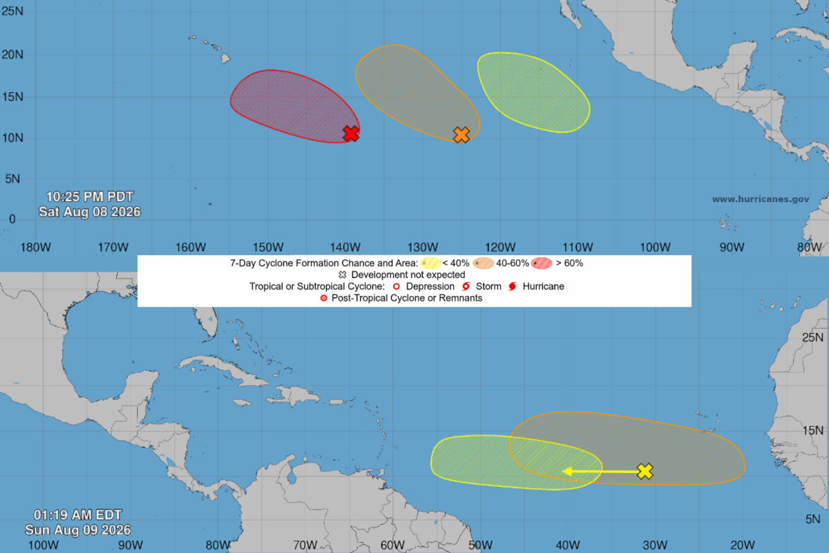
Stepping into the Atlantic theater, forecasters are closely watching two distinct tropical waves, the first of which is currently charting a course southwest of the Cape Verde Islands. This system, a broad and disorganized swirl of rain and wind, is marching steadily westward across the deep tropical Atlantic, drawing energy from the exceptionally warm ocean surface. However, the journey for this initial disturbance is fraught with atmospheric obstacles; meteorologists predict that as the week progresses and the system approaches the Lesser Antilles, it will run headfirst into hostile, high-altitude winds known as wind shear. These upper-level winds act as an invisible barrier, effectively tearing the tops off developing thunderstorms and preventing the system from organizing into a cohesive, rotating storm. Because of these unfavorable environmental conditions, the National Hurricane Center has assigned this first system a near-zero chance of development over the next forty-eight hours and a modest twenty percent chance over the next seven days. For residents of the Caribbean islands, this low probability offers a temporary sigh of relief, but it also serves as a gentle warning that the protective atmospheric shields of early summer are beginning to weaken.
Just behind this first wave lies a second, more formidable Atlantic threat that has captured the close attention of weather experts and emergency planners alike. Expected to push off the African continent early this week, this second tropical wave is entering an environment that appears far more hospitable to tropical genesis, with lower wind shear and abundant moisture fueling its potential growth. Forecasters believe that as this system journeys across the eastern and central Atlantic, it stands a much higher chance of organizing, with a forty percent probability of developing into a tropical depression by the latter half of the week. This region of the ocean is historically referred to by meteorologists as the “main development region,” a vast stretch of water where some of the world’s most infamous and destructive hurricanes have taken their first breaths as humble African easterly waves. The birth of these waves is a fascinating testament to global connectivity, where hot dry air from the Sahara Desert collides with the cooler, humid air of the African Sahel, creating ripples of energy that spill into the Atlantic; watching them develop is a masterclass in patience and scientific observation, as we wait to see if this particular ripple will find the perfect conditions to grow into something much larger.
Meanwhile, the Eastern and Central Pacific oceans are experiencing their own dramatic surge in tropical activity, dominated by a massive, highly organized system churning more than a thousand miles east-southeast of Hawaii. This particular disturbance is producing an expansive canopy of heavy showers and thunderstorms, and scientists are highly confident in its future, placing its chances of developing into a tropical depression at an astounding ninety percent over the coming week as it tracks west-northwestward. Behind this dominant Pacific system, two other disturbances are also being monitored: a mid-level system southwest of the Baja California Peninsula with a fifty percent chance of development, and a weak low-pressure area off Mexico’s southwestern coast holding a mere ten percent chance. The geographic isolation of places like the Hawaiian Islands means that any storm system in the Central Pacific is watched with intense scrutiny, as ocean swells, high surf, and heavy tropical rains can disrupt island life long before a storm’s center ever draws near. These multiple Pacific threats remind us that while the Atlantic often dominates the headlines, the Pacific is a massive, warm engine capable of producing incredibly rapid storm development that requires equal vigilance.
Naturally, the burning question on everyone’s mind when looking at these tracking maps is simple and urgent: Will any of these systems hit land? Currently, there is no cause for immediate alarm, as the Atlantic waves remain thousands of miles away over the open ocean, and the Pacific disturbances are projected to steer generally westward, away from major landmasses. However, meteorologists are quick to emphasize the inherent uncertainty of forecasting systems that have not yet established a well-defined, closed center of circulation. Without a stable “eye” or a clear low-pressure center, computer models struggle to project accurate paths, often spitting out widely divergent tracking lines—affectionately known as “spaghetti models”—that can change drastically from one afternoon to the next. This early stage of tracking is a delicate exercise in risk communication, where weather professionals must balance the need to inform and prepare the public with the responsibility of preventing unnecessary panic, reminding us all that meteorology is as much about managing human expectations and safety as it is about analyzing barometric pressure and wind speeds.
This sudden burst of tropical activity is a textbook reminder of the seasonal calendar, as August historically ushers in the climatological peak of the hurricane season, which culminates in a sharp spike of activity around early September. As the oceans reach their warmest temperatures of the year and the atmospheric winds become more cooperative, the transition from quiet seas to a crowded tracking map can happen with breathtaking speed. While none of the five systems currently being monitored pose an immediate threat to the United States or mainland North America, their simultaneous appearance serves as an invaluable, low-stakes wake-up call for coastal residents. It is the perfect moment to dust off emergency plans, replenish basic hurricane supplies like water and batteries, check insurance policies, and establish clear communication strategies with family members. Ultimately, understanding and tracking the weather is not about living in constant fear of the next big storm, but rather about empowering ourselves with knowledge, respecting the incredible cycles of our planet, and building resilient communities that are always prepared for whatever the oceans might send our way.