


As the calendar turns and June ushers in the official start of the annual Atlantic hurricane season, coastal communities along the sweeping Gulf of Mexico find themselves entering a deeply familiar, yearly rhythm of heightened awareness and quiet preparation. For the millions of residents who call the delicate, winding coastlines of Texas and Louisiana home, this transition into the hot summer months is never merely about beach trips, backyard barbecues, and sunny afternoons; it is also a period defined by clearing out drainage gutters, checking backup generators, restocking family emergency kits, and looking out toward the horizon with a seasoned, cautious eye. This year, that collective, apprehensive gaze has quickly focused on an emerging low-pressure system lingering along the warm waters of the Texas coastline—a thermodynamic disturbance that meteorologists warn has a very real opportunity of becoming the first named storm of the 2026 season. If this swirling mass of moisture, wind, and atmospheric pressure manages to organize itself over the coming hours, it will claim the coveted first spot on this year’s alphabetical roster, earning the name Tropical Storm Arthur. To the casual observer, a weather map filled with brightly colored, shifting radar sweeps might look like nothing more than an abstract scientific puzzle, but to the families living in low-lying bayous, bustling port cities, and quiet coastal towns, these graphics represent the tangible threat of disrupted lives, waterlogged streets, and sleepless nights. This early-season threat serves as a poignant reminder of how deeply human existence along the coast is bound to the unpredictable mood of the ocean, instantly transforming an ordinary weekday into a shared exercise in community resilience, wherein neighbors reach out to check on one another, emergency plans are quietly finalized, and everyone awaits the next professional update with a mixture of hope and practical action.
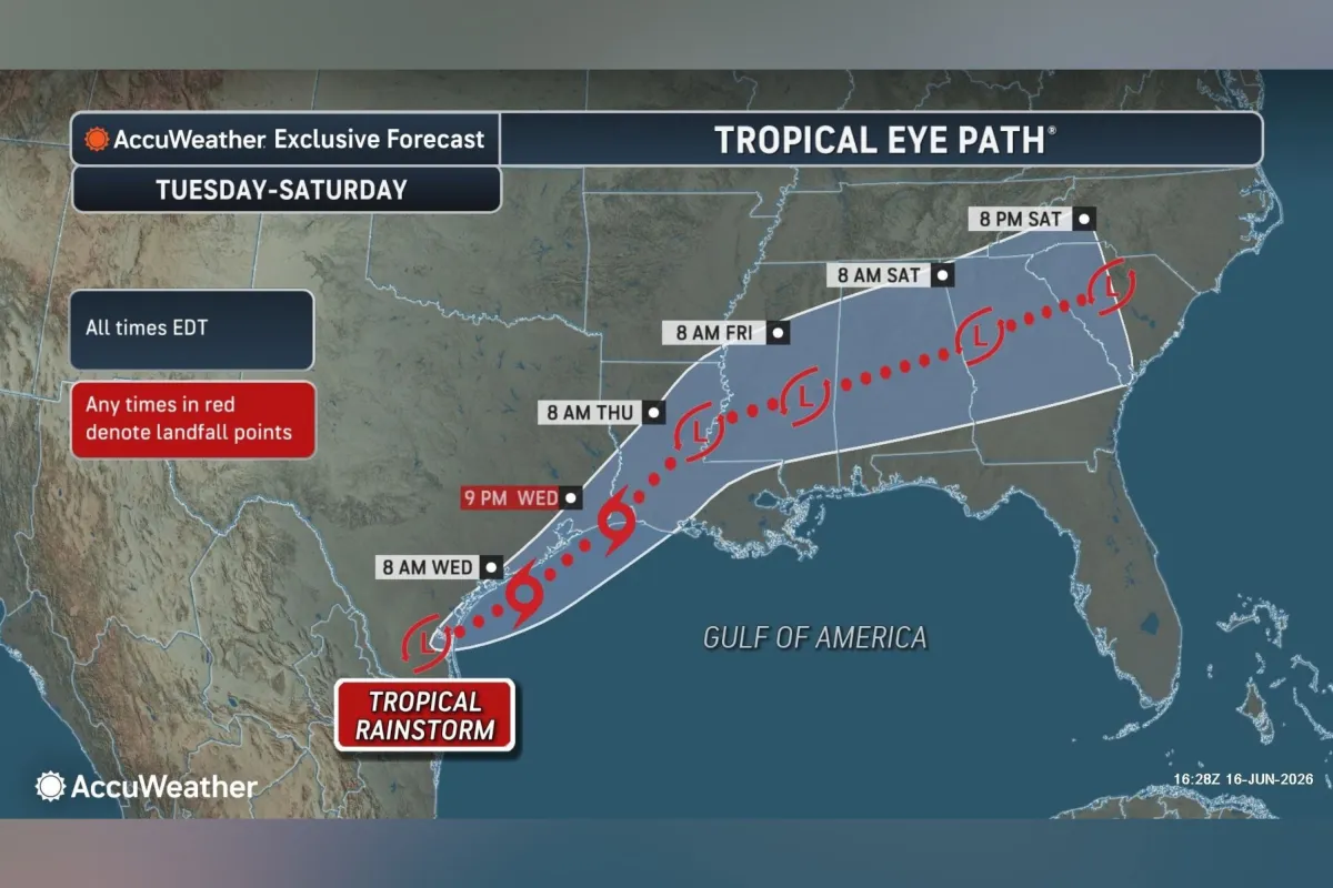
According to the dedicated meteorologists at the National Hurricane Center, this atmospheric disturbance is wasting absolutely no time, actively charting a slow but steady path northeastward along the middle Texas coast, with current models projecting it to move inland over southwestern Louisiana by Wednesday night. Although the agency has assigned the system a sixty percent chance of official tropical formation within a forty-eight-hour window, the primary hazard to human lives and local infrastructure is not merely the potential category of its sustained winds, but rather the sheer, staggering volume of water it is carrying across the sky. Forecasters are issuing urgent, clear warnings of dangerous rainfall totals, predicting a widespread five to ten inches of precipitation, with isolated, vulnerable areas potentially seeing up to an incredible twenty inches of rain by the time the system finally moves inland and begins to weaken or dissipate by tonight or early Thursday. Such an overwhelming volume of water falling in a concentrated period can fundamentally reshape local landscapes in a matter of hours, easily overwhelming drainage networks and turning quiet suburban streets, urban underpasses, and slow-moving bayous into fast-flowing, highly hazardous torrents. This massive water hazard is not confined to the immediate beachheads; it is forecast to stretch across a vast geographic corridor that reaches from the upper Texas coast deep into southern and central Louisiana, across the state of Mississippi, into Alabama, and over into parts of western Georgia and the Florida Panhandle. When weather authorities warn of “dangerous to life-threatening flash flooding,” they are speaking directly to everyday commuters, construction workers, and families whose homes lie in historically low-lying flood sectors, pleading with them to recognize that a system does not need to achieve hurricane status to inflict severe pain and damage on a community.
To protect the public from these rapidly evolving conditions, local offices of the National Weather Service have established a massive protective net of alerts, triggering extensive flood watches that stretch continuously from southeastern Texas, across the watery expanses of Louisiana, Mississippi, and Alabama, all the way into the western Florida Panhandle and portions of Georgia. Alongside these widespread flood alerts, the immediate threat of tropical-force winds has prompted targeted marine and coastal warnings, with a tropical storm warning officially in effect for the region spanning from Sabine Pass to Morgan City, while a tropical storm watch looms tensely from Sargent to Sabine Pass. Behind these sterile, technical designations and geographic coordinates lie thousands of very real, urgent decisions being made by ordinary citizens inside their homes. In kitchens and living rooms across the Gulf Coast, parents are sitting down to review evacuation routes, business owners are deciding whether to board up window fronts, and city crew workers are laboring in the oppressive heat to clear debris from drainage grates so that rainwater has a clear path to escape. Cultivating a deep understanding of these professional weather terms is a vital, life-saving skill in these moments: a “watch” signals that hazardous tropical conditions are possible within the specified area and serves as a call to finalize preparations, while a “warning” indicates that those dangerous conditions are actively occurring or highly imminent, demanding immediate, protective reactions. It is precisely in this high-pressure environment that the true strength of southern hospitality shines brightest, as people proactively check in on elderly neighbors, lend out equipment, and share resources, translating cold, digital warnings into acts of safety.
If the current low-pressure disturbance continues to consolidate and gain strength, the name Arthur will officially launch a new, highly anticipated cycle of nomenclature designed to help the public track, discuss, and prepare for dangerous tropical weather. The practice of systematically naming storms, carefully managed by the World Meteorological Organization, was originally conceived to simplify public communication and eliminate dangerous confusion when multiple weather systems are active simultaneously, replacing awkward latitude and longitude coordinates with easily remembered human names. Following Arthur, the roster of names for the 2026 Atlantic hurricane season will progress down an alphabetical list that includes Bertha, Cristobal, Dolly, Edouard, Fay, Gonzalo, Hanna, Isaias, Josephine, Kyle, Leah, Marco, Nana, Omar, Paulette, Rene, Sally, Teddy, Vicky, and finally, Wilfred. While these names are chosen years in advance by climatologists, they quickly take on immense, permanent historical weight for the survivors of the storms that eventually bear them; a single name can evoke vivid memories of shared hardship, dramatic rescues, and years of rebuilding for decades afterward. Although names further down the list like Josephine, Kyle, or Leah are currently just silent letters on a page, coastal populations view this list with a sober understanding that any one of these names could easily become a definitive, life-altering chapter in their own local history books. This naming system fundamentally humanizes the complex, abstract science of meteorology, translating sweeping thermodynamic atmospheric events into distinct, named challenges that communities can collectively track, talk about, prepare for, and ultimately, overcome together.
While the potential, imminent development of Arthur has put the entire Gulf Coast on immediate alert, the broader scientific outlook for the rest of the 2026 season offers a slight sense of relief, though experienced coastal residents know better than to ever let their guard down fully. The National Oceanic and Atmospheric Administration has forecasted a below-normal Atlantic hurricane season for this year, predicting a total of eight to fourteen named storms overall. This relatively mild prediction stands in stark, comforting contrast to the memories of the highly active 2025 hurricane season, which saw thirteen named storms develop, five of which grew into fully fledged hurricanes, with four of those explosive storms reaching catastrophic Category 4 or 5 status. For the families and local businesses that survived those powerful, destructive storms just one year ago, the emotional, physical, and financial scars of rebuilding are still incredibly fresh, making even a “below-normal” seasonal forecast a source of quiet anxiety and stress. It is an unwritten, universally acknowledged truth along the Gulf and Atlantic coasts that it only takes a single storm hitting a heavily populated area to turn a historically quiet, below-average season into an unforgettable, generation-defining disaster. Climatology can provide percentages, historical models, and regional averages, but it cannot predict the exact day or time that an individual family will have to pack their most cherished possessions into a car and flee inland; therefore, coastal communities approach these seasonal forecasts with a grain of salt, viewing them not as a guarantee of safety, but as an annual invitation to remain constantly vigilant, knowing nature obeys no forecasts.
As the experts at the National Hurricane Center continue to monitor this active coastal disturbance through advanced satellite imagery, radar networks, and hurricane hunter flights, the immediate regional priority remains centered squarely on safety, solidarity, and proactive preparation. In our modern digital age of instant internet notifications, it is incredibly easy for families to feel overwhelmed by the constant, relentless stream of weather data and frightening headlines, but we must remember that this unparalleled access to real-time information also serves as our absolute greatest shield against the unexpected forces of nature. Staying informed by regularly monitoring official local meteorologists and trusted public safety agencies enables individuals to make calm, highly rational decisions rather than reactive, panic-driven maneuvers as the winds begin to rise and the waters start to swell around them. Ultimately, true storm resilience along the coast does not come from steel storm shutters, concrete sandbags, or plywood boards alone; it is found deep within the social fabric of the communities that face these challenges side by side, checking on vulnerable neighbors, sharing extra clean drinking water, and refusing to face the elements in isolation. As Arthur threatens to introduce himself to the coast, the unified response of the region reflects a deep-seated endurance and neighborly grace that has defined these vulnerable coastlines for generations, proving that when science and human empathy go hand-in-hand, we can weather any storm.


