



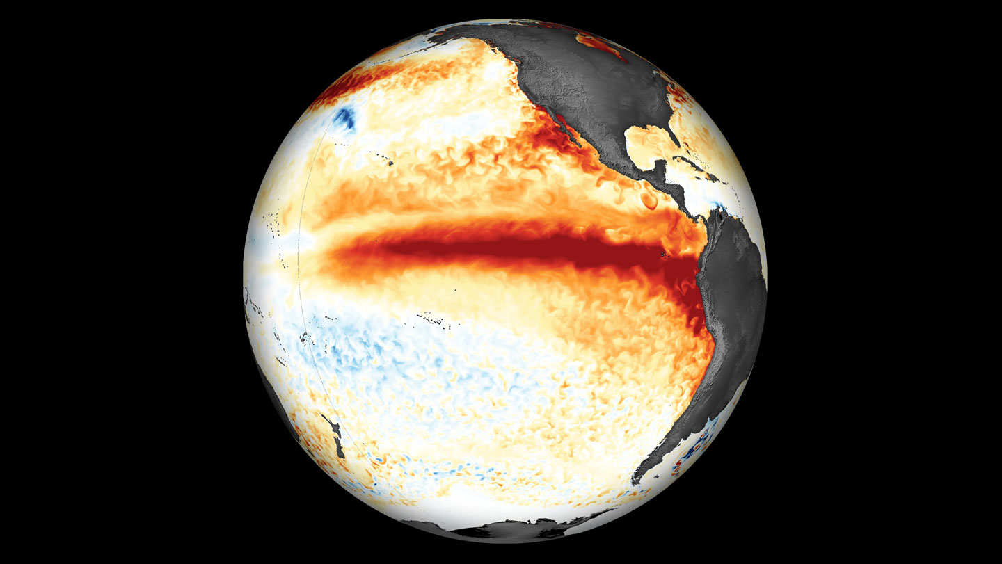
For months, scientists have been sounding alarms about an El Niño that could turn into something the modern world has never seen. Now those alarms are becoming reality. The Pacific Ocean is running a fever, and the numbers are staggering. In the central and eastern equatorial Pacific—the region where El Niño is born—daily sea surface temperatures hit 3.08 degrees Celsius above the 1991–2020 average on September 21. That single daily reading is more extreme than any other El Niño on record, surpassing the old mark of 3.02 degrees set in November 2015. To put it in human terms, imagine a bathtub filled with a thousand gallons of water, heated just a few degrees beyond its all-time high; the energy involved is almost unimaginable. That heat doesn’t just sit there. It rises into the atmosphere, and as it does, it remodels weather across the planet. Scientists have warned for months that this natural climate pattern—a cyclical warming of the tropical Pacific—could release extraordinary amounts of stored ocean heat, spawning droughts, floods, heat waves, and severe storms. The new measurements suggest those warnings weren’t hyperbole. A traditional yardstick for El Niño strength, the Oceanic Niño Index, is now showing an intensity that has no equal in recorded history. And the event may not be done yet. Since El Niño emerged in June, the daily average sea surface temperature in this key stretch of the Pacific has climbed with alarming speed. The anomaly is measured against a baseline from 1991 to 2020, and also compared to 1982 to 2010; either way, the departure from normal is jaw-dropping. It’s like watching a tropical storm grow into a Category 5 in a matter of weeks, except the storm is the size of the entire ocean and its effects will ripple for years. The challenge now is not just to marvel at the record, but to understand what it means for the people who will live through it.
Even with such a dramatic daily reading, scientists are being careful about declaring this the strongest El Niño ever. NOAA hasn’t made that call, because it measures El Niño strength using a rolling three-month average rather than a single day’s spike. And it has updated its methodology, using a new index called the Relative Oceanic Niño Index, which better captures how much El Niño can actually influence weather around the world. By that measure, the 1997–1998 El Niño still holds the crown. But the latest seasonal forecast from NOAA’s Climate Prediction Center suggests that record could fall soon. Climate scientist Nathaniel Johnson, who helps produce those forecasts, calls the event “remarkable” and says it will probably keep building. “We’re probably going to reach our peak within the next few months,” he says. That matters because the heat is not staying in the ocean. Researchers from the Climate Impact Lab at the University of Chicago estimate that the oceanic heat released by this El Niño could push global land temperatures up by about 1.2 degrees Celsius in the coming months. They project that could translate into more than 450,000 additional heat-related deaths by February 2027. That’s not just an abstract statistic; it’s a public health emergency unfolding in slow motion. It means vulnerable people—the elderly, outdoor workers, people without air conditioning—will be living through heat that their bodies aren’t prepared for. The ocean’s fever becomes our fever. For forecasters, the immediate job is to keep watching those daily numbers and to help communities get ready for what’s coming. There is a strange tension in the science right now: the event is already historic, yet its most dangerous consequences may still be ahead.
One of the most urgent questions is how much of this El Niño is our own doing. The answer, for now, is complicated. “It’s really an unanswered question,” Johnson says. The historical record shows more rapid swings between El Niño and La Niña in recent decades, and some climate models suggest that rising greenhouse gas emissions increase the likelihood of extreme swings. But there is no scientific consensus yet on exactly how climate change shapes El Niño—especially one as intense as this. Nathan Lenssen, a climate scientist at the National Center for Atmospheric Research, puts it this way: it’s a matter of debate how much we can directly attribute to climate change. But there’s a crucial underlying truth: because the planet has warmed, the oceans now hold more energy. El Niño is one of the main ways the ocean releases that pent-up heat into the atmosphere. Think of it like a pressure cooker. Climate change didn’t create the pot, but it turned up the heat underneath it, and when the valve opens, the release is wilder. Even if global warming doesn’t cause El Niños, it loads the dice. Every degree of additional ocean warmth means more energy available for storms, more moisture in the air, and more stress on ecosystems and communities. In that sense, this El Niño is not just a natural event; it’s a natural event happening in a fundamentally altered world. The same phenomenon that occurred long before humans were around is now playing out on a hotter stage, and that changes the risks, the impacts, and the record books. It also makes the science harder, because the old rules don’t always apply.
Given the heat now surging through the Pacific, what can we expect? Some impacts are well understood, especially in the tropics, where El Niño’s fingerprints are clearest. The Atlantic hurricane season has already been suppressed, while the Pacific hurricane season has been more active. Droughts have emerged in Central America, and more are likely over northern South America and the Amazon. The Indian monsoon tends to weaken, which can have enormous consequences for agriculture and water supplies across South Asia. As late fall arrives, the effects often reach farther from the equator. The southern United States tends to get rainier, the Pacific Northwest tends to dry out, and the northern United States and Canada often see warmer-than-average temperatures. But there’s an important twist, and it’s one that forecasters are still wrestling with. A more powerful El Niño doesn’t automatically mean more confident forecasts. Lenssen points out that global warming has changed some of the historical mid-latitude responses. For example, recent El Niño events haven’t delivered as much rain to California as older analogs would suggest, partly because other warming ocean patterns have altered the picture. That means forecasters can’t just pull up a map of past El Niños and assume this one will follow the same script. The climate system is full of crosscurrents, and the background warming is rerouting some of the classic signals. In practical terms, communities shouldn’t assume that because this El Niño is stronger, every predicted impact will be more severe. Some might be stronger, some might be different, and some might not show up at all. The responsible approach is to prepare for a wide range of possibilities, rather than a single forecast.
How long will this extraordinary event last? El Niños typically run their course in about a year. Johnson says this one will probably weaken after winter and fade by spring or early summer. But big El Niños often leave a lasting imprint. In the aftermath of a powerful El Niño, the climate system frequently swings to the opposite phase, La Niña, which tends to cool the tropical Pacific and shift weather patterns in its own way. Lenssen notes that a strong El Niño could be followed by a “double La Niña”—two back-to-back La Niña events separated by a brief spell of neutral conditions. That happened after the strong El Niño of 2014–2015, with La Niña conditions in 2016–2017. The prospect matters because La Niña brings its own set of risks, including dry conditions in some regions, heavier rains in others, and a more active Atlantic hurricane season. What sets this event apart, however, isn’t just its eventual strength. Johnson points to the astonishing speed of the transition. Last winter, the Pacific was in a La Niña. In less than a year, it flipped into what could be one of the strongest El Niños ever recorded. “That might be the fastest transition that we’ve seen,” he says. The Pacific has essentially performed a U-turn in a matter of months. That rapid shift leaves little time for ecosystems, water managers, farmers, and emergency planners to adapt. It also makes the current event a uniquely stressful test for forecasters, who are trying to track a system that seems to be moving faster than it ever has before. In a sense, this El Niño is not just breaking records; it’s breaking expectations.
Is there any good news in all of this? Lenssen offers a tentative silver lining. Although much more research is needed, some studies suggest that future El Niños may actually become more predictable as the world continues to warm. That sounds counterintuitive—usually global warming makes things harder to forecast—but in this case, a warmer climate may strengthen the atmosphere’s connection to the ocean, making El Niño’s development more consistent and giving forecasters a clearer early signal. If that turns out to be true, it could provide months of additional lead time to prepare. Instead of reacting to disasters as they unfold, communities could ready themselves in advance. Farmers could choose more resilient crops. Water managers could adjust reservoirs. Emergency agencies could position supplies and personnel before the worst arrives. That would be a genuine game-changer. It wouldn’t erase the dangers of an El Niño, but it could reduce the death toll, the economic damage, and the human suffering that accompany these events. For now, though, the focus is on the present. This El Niño is already rewriting records and reordering weather across the globe. It is a powerful reminder that the planet’s climate system is not a machine with steady settings, but a living, breathing, interconnected system—one that can hold vast amounts of heat for years and then, suddenly, let it loose. The best we can do is pay attention, help the people who are most vulnerable, and use every tool we have to see what’s coming next. In a warming world, that foresight is more valuable than ever.