


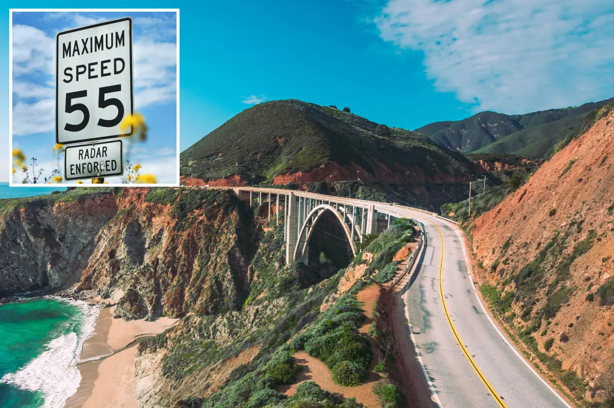
Imagine cruising along California’s legendary Pacific Coast Highway, or PCH as the locals call it, with the shimmering ocean crashing against rocky cliffs to your left and rolling hills dotted with wildflowers to your right. You’ve got the windows down, the salty breeze whipping through your hair, and that feeling of ultimate freedom as you wind through Big Sur’s breathtaking scenery. This stretch of Highway 1 isn’t just a road—it’s an experience, a pilgrimage for anyone who loves the open road, drawing in tourists from around the globe who come to soak in the rugged beauty of Monterey County. But lately, things have changed a bit. Drivers like you and me are being asked to pump the brakes and take it slow on a particularly twisty 5.1-mile segment, where the speed limit has been dropped from 55 miles per hour to just 45 in both directions. It’s a move by the California Department of Transportation, or CalTrans, announced in a straightforward press release that might make you wonder why such a popular spot—loved by families on vacation, cyclists pedaling their way to the next viewpoint, and sightseers snapping photos of seals lounging on the rocks—needs this adjustment. As someone who’s driven this route countless times, I can tell you it’s not about spoiling the fun; it’s about protecting it. Rushing through these curves at high speeds has led to some nail-biting moments, where one wrong turn could mean skidding toward a sheer drop or colliding with an unexpected cyclist emerging from a pullout. The highway is only two lanes wide, carved into the coastal mountains, and during peak season, it’s packed with vehicles pulling over to admire the Pacific’s endless blue expanse. I’ve seen tourists stepping out right onto the road to get that perfect selfie, or a group of cyclists huffing up the inclines, their bright jerseys a stark contrast against the earthy tones of the landscape. It’s exhilarating, but also hazardous. With the new limit in place, the goal is to foster a calmer, more manageable flow of traffic, allowing everyone—motorists, pedestrians, and cyclists alike—to coexist without the constant threat of chaos. Think about it: slower speeds give you that extra second to react to a deer darting across your path or a foggy patch rolling in from the sea. Enforcement starts right away, with new signs already posted along the route, reminding you to ease off the accelerator. It’s not just a bureaucratic decree; it’s a thoughtful nod to the human element on these roads—the folks who venture here to escape the hustle of city life, reconnect with nature, or simply enjoy a peaceful drive. I’ve chatted with fellow drivers who’ve shared stories of close calls, like swerving to avoid a cyclist or slamming on the brakes for a family crossing at an unguarded section. This change feels personal, like the highway is whispering, “Take your time and savor the view.” It builds on the highway’s reputation as a scenic wonder, but with an added layer of care that ensures future generations can keep coming back. Cruising Big Sur has always been about the journey, not the destination, and now it’s even safer, encouraging you to roll down the windows, crank up the tunes, and truly immerse yourself in the moment without fearing the unexpected. As the days stretch longer in the summer, imagine pulling over at one of those pullouts, feeling the sun warm your skin and listening to the rhythm of the waves below. Drivers from all walks of life—weekend adventurers, long-haul travelers, even celebrities who’ve filmed movies here—are all part of this shared experience. The reduced limit isn’t a hassle; it’s a gentle reminder to appreciate the fragility of this paradise. CalTrans didn’t make this decision lightly; it’s born from real-world insights gathered over years of observation. I’ve always appreciated the balance between adventure and safety here, and this tweak seems like a smart evolution. Whether you’re zipping south from Coast Road or heading north toward Garrapata Creek Bridge, the highway remains a tapestry of memories waiting to be made, just at a pace that’s kinder to everyone involved. It’s a small sacrifice for a big payoff: fewer accidents, happier travelers, and a corridor that feels alive with cautious joy. Personally, the next time I drive this stretch, I’ll embrace the slower tempo, using it as an excuse to stop more often, breathe in the ocean air, and maybe even strike up a conversation with a fellow explorer at a scenic overlook. Big Sur isn’t just a drive; it’s a state of mind, one that’s now a little more mindful and a lot more human.
The specific section impacted by this change stretches about 5.1 miles in what’s arguably the crown jewel of California’s coastal highways, nestled in the heart of Big Sur within Monterey County. Running southward from Coast Road all the way up to the northern side of the Garrapata Creek Bridge, this winding two-lane road hugs the coastline with an intimacy that’s both thrilling and intimidating. Imagine starting near the top, where the land opens up slightly, allowing a few scattered trees and wild grasses to frame your view before plunging into sharper bends that seem to mimic the ocean’s ebb and flow. If you’re traveling south, the highway dips and curves through valleys carved by ancient rivers, with intermittent pullouts where tourists pile out to gaze at the surging Pacific, its waters a breathtaking blue that shifts with the light. Heading north, the landscape tightens, the cliffs looming higher, and the road feels like it’s threading through a natural sculpture of rock and water. This segment is no ordinary commuter road; it’s a tourist magnet, drawing busloads of visitors from San Francisco, Los Angeles, and beyond, all eager to experience the raw majesty of Big Sur. Families cram into minivans to point out redwoods hugging the hillside, cyclists brave the gusts in packs, battling headwinds that make each pedal a victory, and sightseers—myself included—often stop abruptly to capture the drama of a whale breaching in the distance or a sunset painting the sky in hues of orange and gold. During peak times, like weekends in spring or fall, the road transforms into a ribbon of motion, with motorcycles revving around corners, RVs inching along the narrow lanes, and the occasional horse trailer adding a rustic touch. I’ve driven it on foggy mornings when visibility drops to mere feet, the world shrinking to just the yellow center line and the guardrails that hug the edge of eternity. Pedestrians add another layer of unpredictability, darting across unmarked crossings or wandering onto the pavement for a closer look at the tide pools. Cyclists, with their helmeted heads down against the wind, navigate the same pavement, relying on the goodwill of motorists to give them space. The road’s curves are notoriously tight, some measuring just a couple hundred feet in radius, forcing drivers to weave left then right as the coastline snakes outward and inward. Parked cars in roadside pullouts are a common sight—families unloading picnic baskets, photographers setting up tripods, or hikers gearing up for trails that lead to hidden beaches. This isn’t just traffic; it’s a melting pot of human activity, where the thrill of the unknown meets the realities of a confined space. Living in California, I’ve seen many highways evolve, but this one feels special, like a living testament to human curiosity and nature’s grandeur. The new 45 mph limit acknowledges the diversity of road users, creating room for patience and awareness. Tourists often say this stretch feels akin to a moving postcard, but without care, it could become a scene of regret. I’ve overheard stories from local businesses, like the quaint cafes in Carmel or Bixby Creek Bridge, where drivers recount the beauty and the close shaves. Cyclists I’ve met on the route talk passionately about the shared road dynamic, how pushing the pace too fast can turn camaraderie into conflict. Sightseers mention the magic of stopping for a quiet minute by the sea, feeling insignificant amid the waves. This change isn’t about restriction; it’s about enhancing the human connection to this place. As enforcement ramps up, drivers are encouraged to adapt, not resent, the slower pace, using it to observe details they might miss at 55 mph—like the intricate patterns of kelp floating on the surface or the distant silhouette of surfers riding the swells. In a state obsessed with speed and progress, Big Sur reminds us there’s wisdom in deceleration, allowing the soul to catch up with the body. Families driving here bond over the shared exclamations of awe, and solo travelers find solace in the solitude amplified by caution. The impacted area embodies the essence of California’s coastal spirit—vibrant, unpredictable, and profoundly human—urging us to travel not just with our eyes, but with our hearts.
At the heart of this speed limit adjustment is a deep commitment to safety, something that resonates personally for anyone who’s ever felt that jolt of adrenaline on these curves. CalTrans officials, drawing from a comprehensive engineering and traffic survey, crafted this change to promote a more orderly flow of traffic along the narrow, two-lane highway, where chaos could easily derail the serenity. They’ve pored over data on roadway conditions, crash histories, and how drivers actually behave in this picturesque yet perilous environment, identifying patterns that highlight the risks of high speeds. For instance, the highway’s rugged terrain means tight curves that demand precise navigation, and with the constant presence of parked vehicles in pullouts, emergency maneuvers become fraught with danger. I’ve experienced this firsthand—during a drive, a line of cars braking suddenly for a pulled-over RV turned a smooth glide into a heart-pounding gridlock, underscoring how one driver’s haste can ripple through the flow. Pedestrians venturing onto the road for photos or crossings add unpredictability, creating moments where reaction time is everything. Cyclists, sharing the same asphalt, face heightened vulnerability as they pedal against the elements, their movements a ballet of bravery that motorized traffic must respect. The survey highlighted these interactions, revealing that at higher speeds, collisions—whether head-on, sideswipes, or run-offs—were more frequent, especially in foggy patches or during tourist surges. CalTrans didn’t just analyze numbers; they brought in human stories, imagining the families who vacation here, the locals commuting to work, and the thrill-seekers who treat the highway like a rollercoaster. The goal is to minimize those serious incidents, turning potential tragedies into manageable flows. Imagine easing into a curve at 45 mph, giving yourself a buffer against the unexpected—a biker rounding a bend or a sudden peacock (yes, they’re real here) strutting into the road. This isn’t about disabling adventure; it’s about safeguarding it, ensuring that the highway remains a gateway to joy rather than a source of sorrow. As a driver, I’ve grumbled at speed limits before, but here it feels justified, like a collective agreement to prioritize lives over velocity. The slower pace allows for better sight lines, reducing blind spots where cyclists or walkers might appear without warning. It also addresses environmental factors, like the infamous Big Sur winds that can push vehicles sideways or the seasonal mists that obscure the path. Safety isn’t abstract; it’s tangible in the smiles of kids pointing at dolphins from pullouts or the gratitude of cyclists who feel seen and protected. This decision mirrors broader road safety efforts statewide, where departments like CalTrans use data-driven insights to protect human experiences. Drivers are urged to embrace it, perhaps by planning longer journeys to account for the reduced speed, turning potential annoyance into opportunity. In the end, this change humanizes the road, recognizing that behind every steering wheel is a story—one of connection, caution, and care.
The process behind rolling out this lower speed limit involved months of meticulous study and collaboration, ensuring the decision was grounded in real-world realities rather than arbitrary rules. CalTrans, working alongside the California Highway Patrol, conducted an engineering and traffic survey that dove deep into the specifics of this Big Sur stretch, evaluating everything from the road’s physical attributes to the behaviors of its diverse users. They analyzed crash data over multiple years, pinpointing hotspots where curves, cliffs, and congestion intersected to create dangers—such as the Garrapata Creek Bridge area, where the road narrows even further, or sections south of Coast Road prone to tourist bottlenecks. Factors like roadside pullouts crammed with parked vehicles were scrutinized; these spots, while essential for enjoying the views, become hazards when drivers whip past at high speeds, potentially causing sideswipes or run-offs. Pedestrians and cyclists were factored in as equal rights holders on the roadway, with surveys documenting how their presence demands extra vigilance from motorists. The tight curves, carved into the coastline like a serpent’s path, amplify risks on rainy days or when fog rolls in, reducing traction and visibility. I remember chatting with a survey team once during a visit—they were out there with clipboards, chatting with cyclists and locals, piecing together a holistic picture of road life. They considered driver psychology too, noting how the scenic distractions could lead to inattention at higher speeds, turning a dream drive into a nightmare. This wasn’t rushed; it stemmed from California’s Vehicle Code and federal roadway safety guidelines, which emphasize reducing serious crashes and fatalities through informed zoning. By integrating crash histories with traffic flow models, officials could predict how the change would alleviate bottlenecks, creating a smoother, more predictable experience. For me, as someone who’ve witnessed the transformation from chaos to order on similar roads, this methodical approach feels reassuring—it’s not about punishment, but prevention. The survey included input from CHP officers who’ve patrolled these lanes, sharing anecdotes of near-misses that informed the lower limit. Cyclists, interviewed for their expertise, advocated for consideration of their speeds and rights, highlighting how a 10 mph drop in the limit could mean the difference between safety and danger. Parked vehicles were another key element, as they force drivers to change lanes or slow abruptly, disrupting traffic harmony. All this culminated in a recommendation that balanced engineering precision with human empathy, ensuring the highway serves its purpose as both a practical route and a scenic escape. Now, with signs in place and enforcement kicking in immediately, it’s clear this isn’t lip service—actual lives are at stake. Broader efforts across California echo this, where similar tweaks on highways like Route 101 or I-5 have slashed accident rates, proving data doesn’t lie. Drivers are key players here, adapting to these changes to reap the benefits of a safer drive. Thinking back to my own experiences on this road, I see parallels to everyday life: sometimes, slowing down reveals more beauty than rushing can ever capture.
In the spirit of this speed limit overhaul, California Highway Patrol Captain Erica Elias offered words that cut through the technical jargon, reminding us all of the human stakes involved. “By implementing the recommended lower speed limits,” she stated, “we can effectively promote the orderly movement of traffic while creating a safer environment for all users of Highway 1.” It’s a powerful endorsement from someone on the front lines, whose job involves responding to the aftermath of highway incidents. Elias emphasized how slower speeds grant motorists greater reaction time, crucial for navigating the roadway’s surprises—be it a sudden curve, an obscured cyclist, or a family crossing unawares. “Reducing the likelihood of collision and enhancing overall road safety,” she added, painting a picture of prevention over cure. Her comments resonate deeply, especially when you consider the diverse people who travel here: vacationing families anxious about their kids’ safety, seasoned cyclists pushing physical limits, and solo drivers like myself seeking respite from urban stress. Enforcement is no longer a vague threat; updated speed limit signs dot the 5.1-mile stretch, popping up south of Coast Road and north of Garrapata Creek Bridge, signaling to everyone that this is serious business. CHP officers are already monitoring for compliance, using radar and patrols to ensure adherence, transforming intention into action. But it’s not punitive—drivers are encouraged to view it as a shared responsibility, one that fosters trust and cooperation among road users. I’ve spoken with locals who appreciate how this creates a more courteous atmosphere, where waving thanks to a yielding cyclist becomes the norm. For tourists, the slower pace invites deeper engagement with the environment, turning a quick pass through into a series of meaningful stops. Elias’s perspective underscores the highway’s role as a communal space, not a race track. Broader efforts by state transportation officials tie into this, drawing on engineering analysis, state laws, and federal guidelines to curb fatalities statewide. In California, where roads crisscross vast landscapes, initiatives like this are part of a larger push to make highways survivable for humans, not just traversable. Drivers adapting to 45 mph might grumble initially, but feedback from similar projects shows gratitude sets in, with users reporting fewer stressors and more enjoyment. For those cycling or walking, it’s a boon that aligns with their needs for visibility and space. This isn’t about stripping freedom; it’s about enhancing it, ensuring Big Sur remains a haven accessible to all. As someone who values these drives, I echo Elias’s sentiment—safety breeds better flows, turning potential turmoil into tranquility.
Looking at the bigger picture, this adjustment to Big Sur’s Highway 1 is just one thread in California’s ongoing tapestry of roadway reforms aimed at saving lives and enriching experiences. State transportation officials justify such zoning decisions using a layered approach that combines rigorous engineering analysis, provisions from the California Vehicle Code, and insights from federal roadway safety guidance—all part of concerted campaigns to slash serious crashes and fatalities throughout the Golden State. It’s not isolated; across the country, agencies are reevaluating speeds on scenic routes to mirror real-world dynamics, where aesthetics meet functionality. For example, similar limits have been applied on stretches of the Blue Ridge Parkway or Oregon’s Coast Highway, yielding impressive drops in incidents while preserving natural beauty. Here in California, the emphasis is on mindful design, recognizing that highways like Highway 1 aren’t mere conduits; they’re symbols of freedom and fragility. The 45 mph limit on this Monterey County segment builds on successes elsewhere, where lower speeds correlate with reduced severity of accidents, giving emergency responders fewer heart-wrenching calls. Drivers are pivotal in this evolution, their compliance turning policy into practice, fostering a culture where caution is cool rather than constraining. I’ve reflected on how this ties into personal stories—families planning trips now factor in extra time, turning potential delays into opportunities for connection, like roadside picnics or impromptu hikes. Cyclists report feeling more secure, integrating joys of motion with peace of mind. Sightseers, once rushing past views, now linger, discovering hidden details in the landscape. Enforcement isn’t draconian; it’s supportive, with educational campaigns reminding folks of the “why” behind the “what.” Statewide, CalTrans hosts workshops and apps tracking real-time hazards, empowering drivers to anticipate challenges. This mirrors federal mandates under programs like Safe Roads for the 21st Century, which prioritize vulnerable users—pedestrians, cyclists, and even wildlife. For a state plagued by traffic woes, from LA freeways to coastal cragways, initiatives like this signal progress. As motorists, we adapt, embracing slower speeds as an investment in collective well-being. Big Sur, with its timeless allure, becomes safer, more inclusive—a place where human stories unfold without interruption. Join the conscious drive, download apps for updates, follow safety tips, and subscribe to alerts. Your next journey could be the adventure that changes everything, one mindful mile at a time. Embrace the slow burn of California’s coast; it’s where progress and preservation intertwine.


