


The Night the Streetlights Danced: How Billions of Smartphones Created the World’s Most Powerful Collaborative Earthquake Alert System
A Sudden Alarm on the Road to the Cinema
On an otherwise ordinary Wednesday evening in Caracas, Venezuela, Jose Flores was navigating the bustling city streets with his family, their minds occupied with the simple anticipation of taking their children to see Toy Story 5. The mundane comfort of their drive was abruptly shattered when an unfamiliar, piercing alarm blared from his wife’s Android smartphone, flashing an urgent warning of an imminent earthquake. For six agonizing seconds, the cabin of their car remained still, suspended in a brief vacuum of confusion, before the first violent tremors of a historic tectonic event tore through the asphalt beneath them. Venezuela, like many developing nations situated along active fault lines, completely lacks a state-run, terrestrial seismic broadcast network to warn citizens of oncoming sub-surface disasters. Instead, the lifeline that reached the Flores family—and millions of others across the region—was powered entirely by a decentralized, cloud-based network of consumer mobile phones. On that fateful evening, the earth erupted with a staggering pair of consecutive earthquakes, registering magnitudes of 7.2 and 7.5, the latter marking the most intense seismic disturbance to strike Venezuela since 1900. Yet, moments before the ground began its destructive heave, millions of citizens were granted a precious, life-saving window of preparation, demonstrating how modern smartphone technology has quietly democratized disaster response in parts of the world previously left defenseless.
The Pocket-Sized Seismograph: How Global Smartphones Form a Modern Defense Network
   TYPICAL GOVERNMENT SYSTEM                  GOOGLE EARTHQUAKE ALERTS SYSTEM

 [ Underground Sensors ]                      [ Stationary Android Phones ]
            │                                              │
            ▼ (Seismic data)                               ▼ (P-wave detection)
 [ Centralized Gov Agency ]                   [ Google Cloud Servers ]
            │                                              │
            ▼ (Cell broadcast)                             ▼ (Algorithmic processing)
  [ ALL PHONES IN REGION ]                     [ TARGETED ANDROID USERS ]
The quiet driver of this modern disaster response is the Google Earthquake Alerts system, an innovative infrastructure built upon the massive footprint of the Android operating system, which runs approximately 70 percent of all smartphones globally. To understand how Google transformed millions of standard pocket devices into a deeply integrated, planetary seismograph station, one must look at the highly sensitive microtechnology nestled within these consumer electronics. Inside almost every modern smartphone lies a tiny component called an accelerometer—the very same sensor responsible for detecting when you rotate your phone to view a landscape photo or track your steps during a morning run. When an earthquake strikes, these miniature silicon sensors are capable of detecting the initial, subtle vibrations of seismic waves traveling through the earth’s crust. If a phone is stationary—lying flat on a dinner table, resting on a nightstand, or tucked away in a backpack on the floor—it acts as an individual node in a massive, crowd-sourced seismology experiment. By harvesting these microscopic movement signatures from more than two billion active Android devices worldwide, Google has successfully bypassed the need for millions of dollars of buried physical infrastructure, creating a dynamic, cloud-powered early warning shield that operates across borders.
The Physics of Tremors and the Race Against the Destroyers
 EARTHQUAKE EPICENTER
          │
          ├──► [ P-Wave (Primary) ] ──► 4 miles/sec ──► Light vibration (Triggers Phone Sensor)
          │
          └──► [ S-Wave (Secondary) ] ─► 2 miles/sec ──► Violent shaking (Causes Destruction)
To appreciate the sheer speed at which this software must operate, one must look at the fundamental physics of how earthquakes travel through the terrestrial crust. When a subterranean fault line slips, it immediately radiates two distinct varieties of energy waves that move outward at wildly different velocities: Primary waves (P-waves) and Secondary waves (S-waves). P-waves are fast-moving, relatively gentle compressional waves that zip through the bedrock at roughly four miles per second; while they rarely cause structural damage, they serve as the Earth’s natural acoustic precursor. Running at about half that speed are the highly destructive S-waves, shear waves that shake the ground sideways and up-and-down, tearing down brick walls, snapping power lines, and mimicking the motion of a turbulent ocean. The Android seismic detection system is engineered to catch these subtle, early-arriving P-waves, instantly converting the physical vibrations into digital packets of data that are shot straight to central processing servers. The primary engineering hurdle is filtering out normal human activity—such as a user dropping their keys or a heavy truck rumbling past—which is achieved by requiring hundreds of nearby phones to register identical, synchronized vibrations within milliseconds of one another. Once the cloud algorithms filter out this environmental noise, they instantly project the quake’s epicenter and magnitude, calculating exactly who lies in the path of the dangerous, slower-moving S-wave.
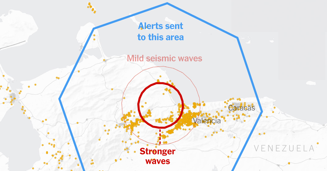
Anatomy of a 21-Second Crisis: Mapping the Venezuelan Alerts
| Time Elapsed | Event Milestones & System Activity |
|---|---|
| 0 Seconds | An underground fault slips, initiating the first earthquake. |
| 3 Seconds | Fast P-waves hit the surface; nearby stationary phones immediately transmit data to Google servers. |
| 9 Seconds | Google’s cloud engines process the incoming data and dispatch the very first alerts to local residents. |
| 15 Seconds | The system broadens the alert radius, pushing warnings to the vulnerable, high-density capital of Caracas. |
| 21 Seconds | Over 11 million people receive customized emergency alerts across the country before major shaking hits. |
The terrifying efficiency of this algorithmic relay race was put to the ultimate test during Wednesday’s double-shaking event in Venezuela, where milliseconds meant the difference between safety and catastrophic injury. Marc Stogaitis, a principal software engineer at Google who spearheads the development of the early warning system, revealed that the epicenters of both quakes were located directly beneath heavily populated urban centers, making rapid detection exceptionally difficult. Within just three seconds of the initial fault slip underground, local stationary smartphones picked up the faint, incoming P-waves and fed the digital telemetry to Google’s cloud engines, which verified the event and pushed out the initial round of alerts a mere six seconds later. As the ground continued to tear, the system continuously analyzed the real-time feedback loops, mathematically reassessing the scaling magnitude and expanding the alert radius dynamically outward toward remote suburbs and the capital city of Caracas. When the second, even more violent 7.5-magnitude earthquake struck shortly after the first, the overlapping waves began to cascade; the system adapted instantly, treating the dual quakes as a singular, prolonged disaster to keep warnings flowing to those most at risk. In total, the system generated over 11.4 million alerts across the country, distributing customized warnings ranging from gentle advisories to thunderous “Take Action” alerts that urged nearly 1.4 million citizens in the danger zone to immediately seek shelter.
Bridging the Global Security Divide Through Innovative Software
The outstanding performance of this consumer-led technology highlights a stark division in global disaster mitigation: the immense financial gap between wealthy, industrial nations and developing societies. Advanced, government-operated early warning systems—such as Japan’s revered J-Alert network or the United States Geological Survey’s ShakeAlert system along the West Coast—rely on extensive subterranean networks of scientific-grade seismometers that are permanently wired to state communication grids. These physical networks are remarkably precise and can push emergency warnings directly to any device via broadcast systems, but they cost tens of millions of dollars to install and require perpetual funding to maintain, a luxury beyond the reach of many high-risk nations. Since Google introduced its software-driven detection approach in 2021—piloting the project in seismically active regions like Greece, Turkey, New Zealand, Central Asia, and the Philippines—it has expanded to nearly 100 countries as of late 2023. By leveraging existing civilian hardware, this system bypasses expensive barriers to entry, giving citizens in vulnerable volcanic and tectonic zones immediate access to the same grade of early warnings enjoyed by the world’s wealthiest metropolitan hubs.
The Human Element: Bridging the Gap Between Digital Alerts and Safe Action
While the engineering behind this planetary-scale alert system is undeniably impressive, the true gauge of its success lies in human behavioral psychology: a few seconds of warning is only useful if citizens understand how to act upon it. Although it remains too early to precisely quantify how many lives were saved or injuries prevented during Wednesday’s historic crisis, emergency experts emphasize that even a brief five-second window is more than enough time for people to “drop, cover, and hold on,” or evacuate unstable, low-rise masonry structures. Back on the roads of Caracas, the Flores family had to learn this lesson in real-time, struggling to understand the sudden scream from their phone before the physical realities of the earthquake took hold around them. They initially mistook the heavy vibrations for the deep-set potholes that routinely plague Venezuelan roadways, but they realized the danger when they watched the massive steel streetlights begin to wildly “dance” in the evening air. Reflecting on the terrifying event, Jose Flores spoke of the profound paradigm shift his family experienced, expressing a newfound trust in the modern technology that successfully anticipated a major natural disaster before it could be felt by human senses. As climate change and seismic instability continue to present threats to global communities, the success of the Venezuelan response suggests a promising future where our shared digital footprints can be transformed into a shield for humanity.


