



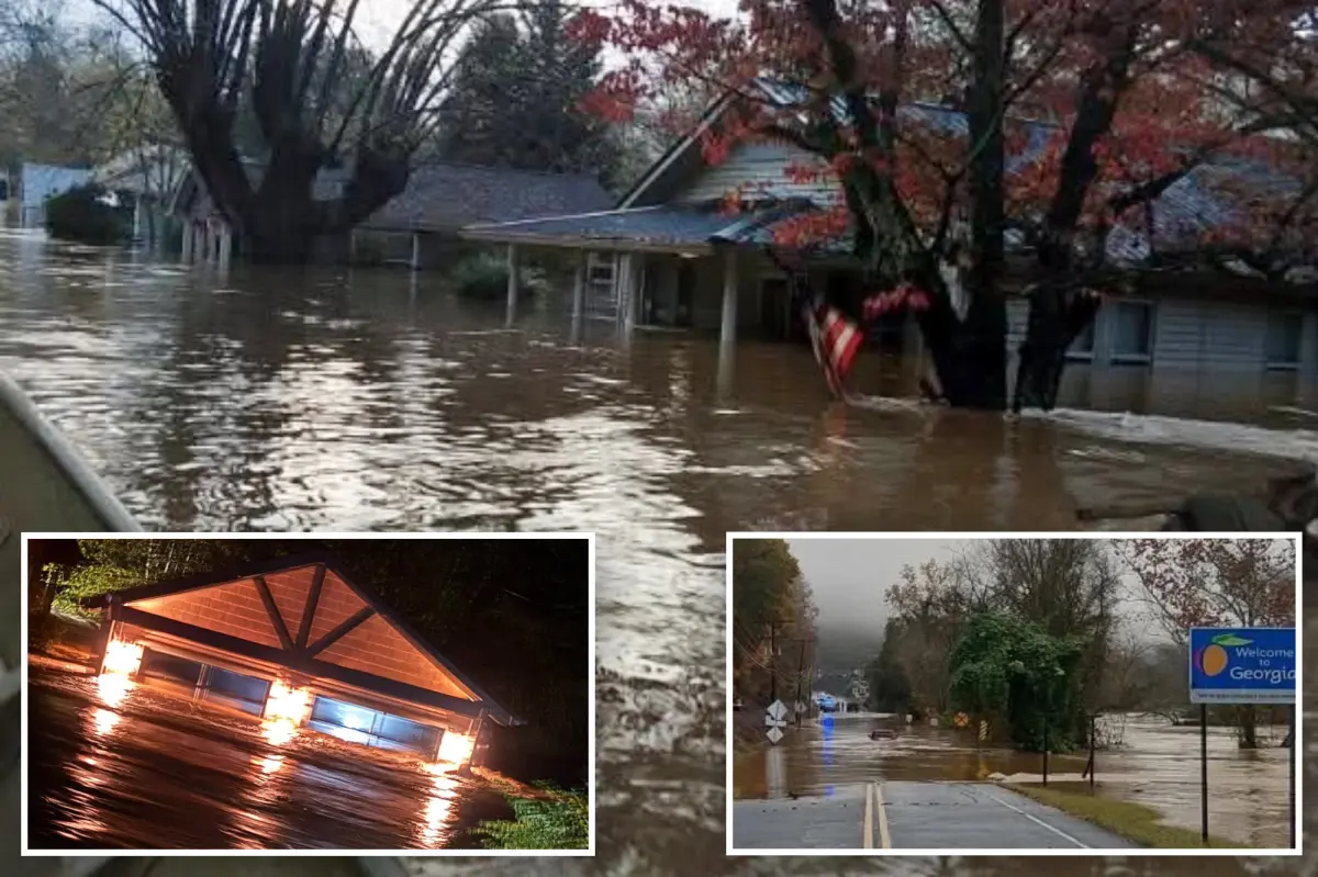
Before dawn on Thursday, the border region between Tennessee and Georgia became the center of a fast-moving, life-threatening weather emergency. Torrential rain fell for hours across Polk County, Tennessee, and Fannin County, Georgia, triggering Flash Flood Emergencies along a state line already familiar with mountain flash flooding. What began as a line of severe storms along the southern end of a massive cross-country system turned into a nightmare for small towns tucked into river valleys. In McCaysville, Georgia, police were not politely suggesting caution — they were urging people in some neighborhoods to evacuate immediately, just before 3 a.m. local time. As the night wore on, county officials confirmed that swiftwater rescues were underway, with water rising into multiple homes and families needing help escaping the floodwaters. The City of McCaysville declared a state of emergency shortly after 5 a.m., a formal declaration that underscored how dangerous the situation had become. The flooding even caused a propane tank to catch fire at a local business, a surreal and unsettling image for residents who were already dealing with water rising through their streets. The Ocoee River, usually a scenic and popular river for rafting and recreation, surged into major flood stage after somewhere between 5 and 8 inches of rain fell across much of the region in only 12 hours. Georgia State Patrol helicopters were placed on standby to help with evacuations, and the neighboring city of Copperhill, Tennessee, took the extraordinary step of announcing that the entire city was closed. Officials in Copperhill warned people to stay away from downtown and any areas along the river. The threat was so serious that Polk County, Tennessee, closed all schools for the day, understanding that sending buses out onto flooded roads would be reckless and dangerous.
For people in those small Appalachian communities, the night unfolded not as a normal storm but as a series of tense decisions and desperate moments. Imagine waking up to the sound of rain so heavy that it drowns out every other noise, only to check your phone and see an emergency alert telling you to leave your home. That was the reality for residents in McCaysville, where police went neighborhood by neighborhood, urging people to evacuate before rising water cut off escape routes. First responders worked through the darkness, moving from house to house as the Ocoee River climbed higher and higher. Each rescue carried its own kind of fear, not just for the people being pulled from their homes but for the rescuers themselves, who could not always see what was waiting beneath the murky, rushing water. The propane tank fire added another layer of danger, forcing crews to juggle flooding and firefighting at the same time. In a disaster like this, the mundane suddenly turns menacing. A place where people went to work the day before, a downtown street lined with small shops, an elementary school where children would normally be learning — all of it became hazardous. The adrenaline of the early morning gave way to exhaustion as daylight revealed the true scale of the damage. For those who evacuated, there was no quick return home, only the uncertain waiting game that follows every flood. The declarations from local leaders were blunt, and they were necessary. They wanted residents to understand that this was not simply a rainstorm. Rivers were rising, roads were disappearing beneath the water, and in some places, the safest thing a person could do was stay away.
As the sun came up on the Southeast, the same enormous storm system that had caused so much chaos was already beginning to push toward the East Coast. The storm had a long history behind it, stretching across the country, and now it was set to bring rain to a region that had not seen a meaningful drop in weeks. For much of the Northeast, this was not just another wet forecast; it was the end of a notable dry streak. New York City, Philadelphia, and Boston had all gone more than two weeks without measurable rain, and drought conditions had quietly worsened across New England, particularly in Maine. Lawns had turned brown. Reservoirs had lowered. Fire risk had increased in some areas. The rain approaching along the Interstate 95 corridor was therefore a welcome sight to many, a chance to wash away the dust and restore a little green to the landscape. But after watching what had just happened in Tennessee and Georgia, forecasters and residents alike knew that rain could be a double-edged sword. What sounds like relief on paper can become a problem when too much of it falls in too little time. The storm system was expected to bring showers and thunderstorms along the East Coast through Thursday, with more than an inch of rain possible across much of the I-95 corridor. Some coastal areas, from Virginia up through southeast New England, could see localized amounts of 2 to 3 inches. That is not necessarily a catastrophic amount, but on dry, hard ground, even a few inches of rain can pool in low-lying streets and overwhelm drainage systems.
Forecasters were not predicting another flash flood emergency for the Northeast, but they were keeping a close watch on the timing and intensity of the rainfall. Friday was expected to bring a Level 1 out of 4 flash flood risk for parts of Suffolk County on New York’s Long Island, as well as portions of eastern Connecticut and southeastern Massachusetts. A slightly higher Level 2 threat was forecast for Newport and Providence in Rhode Island, along with parts of southeastern Massachusetts. The rain, forecasters said, would continue through Friday and then taper off from south to north, but it would not disappear quickly. Lingering rain could continue across southern New England into Saturday morning. For a region that had enjoyed an unusually long stretch of dry, sunny weather, this sudden shift to cloudy skies and steady rain was a major change. For some, it was a reason to smile. The rain would help ease drought conditions, reduce the risk of wildfires, and give plants and trees a much needed drink. For others, especially those with basements prone to flooding or commuters navigating crowded highways, the rain was more of a headache. Minor flooding was possible, and urban areas with poor drainage could see water pooling under overpasses and along curbs. Still, compared to the life-threatening flash floods in the Appalachian foothills, the Northeast’s outlook seemed manageable. It was a reminder that the same weather system can mean one thing for one region and something entirely different for another.
Meanwhile, the rest of the country was dealing with its own share of extreme weather. Just days before the flooding in Tennessee and Georgia, severe storms had raced across the South, spawning Tornado Warnings in northern Louisiana. A tornado touched down in Bossier Parish, Louisiana, late Tuesday morning, and FOX Weather Storm Tracker Brandon Copic captured footage of it, giving viewers a firsthand look at the danger as it unfolded. That storm was part of the same volatile weather pattern that eventually led to the torrential rain along the Tennessee-Georgia border, a reminder that severe weather often comes in many forms. But while the South was dealing with tornadoes and the Southeast was dealing with flash flooding, parts of the Southwest were still reeling from a completely separate flooding disaster that had unfolded over the weekend. The damage there was described as historic. Roads remained closed because of residual flooding and damage left behind by the floodwaters, and communities were only beginning to assess what had been lost. In Flagstaff, Arizona, police said they were investigating a second death as potentially weather-related after a body was found in a stormwater drainage area on Monday. The news added a somber note to an already difficult recovery. For families who had survived the flood, the ordeal was far from over. The water may have receded in some places, but the destruction it left behind — ruined homes, washed-out roads, debris scattered across yards — would take weeks or months to clean up. And in the mountains of the Southwest, the danger had not passed completely. Evacuations remained in effect near the San Juan River in New Mexico and Colorado, where communities were waiting to see whether the water would rise again or finally begin to fall.
These overlapping weather emergencies tell a broader story about how fragile everyday life can be in the face of nature’s power. In the span of a single week, Americans in different parts of the country faced tornadoes, dangerous heat, historic flooding, and the rising threat of flash floods. The systems were all different, but the human response was the same: families evacuating, first responders pushing into danger, neighbors checking on one another, and local officials making difficult decisions with incomplete information. The word “historic” gets used a lot during extreme weather events, but behind that word are real people. They are parents carrying children through floodwater, elderly residents being helped into rescue boats, business owners watching a lifetime of work disappear beneath the current. Yet these moments also bring out resilience and community spirit. In the aftermath of disaster, people do not wait for the government to tell them how to help. They offer shelter to strangers, bring food to rescue workers, and share information about which roads are impassable. The storms move on, but the recovery takes time. The rain will eventually stop, the rivers will eventually fall, and the skies will eventually clear. The memory of the water, however, will linger. For communities along the Tennessee-Georgia border, the San Juan River, and the many other places touched by severe weather, the road ahead involves cleaning up, rebuilding, and preparing for whatever the next storm may bring. All any of us can do is pay attention to the warnings, take them seriously, and remember that behind every weather forecast is the safety of people who call those places home.