







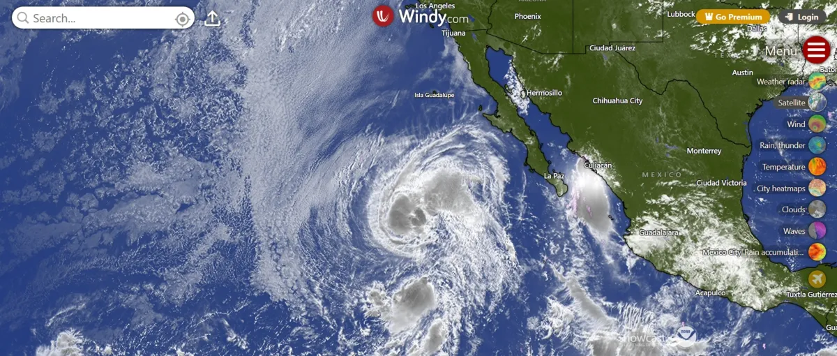
Out in the vast, lonely expanse of the eastern Pacific Ocean, a dramatic meteorological spectacle is unfolding—a phenomenon that looks less like a routine weather forecast and more like a scene from a nature documentary about chaotic survival. Two tropical storms, Iselle and Julio, are caught in a deadly spiral, doomed to an inevitable encounter that will end with one of them utterly consuming the other. Late Tuesday morning, forecasters at the National Hurricane Center confirmed that this merger is imminent. Tropical Storm Julio, the smaller and weaker of the pair, is caught in a high-speed chase, racing north-northeast at a blistering 22 miles per hour, directly into the waiting maw of its larger, bulkier sibling. Tropical Storm Iselle, boasting winds of 70 miles per hour and a much more substantial footprint, is ambling along at a leisurely pace of just 10 miles per hour, acting as a stationary giant waiting for its smaller challenger to arrive. It’s a David-and-Goliath story, except David doesn’t have a slingshot; Goliath simply has a much bigger chest to absorb the blow. The imminent absorption is creating a strikingly beautiful, if slightly ominous, visual on satellite imagery, showing the two swirling masses locked in a gravitational waltz over the open water, far from any human landfall, but close enough to the Baja California peninsula to generate eerie, dangerous swells. For those watching the animated loops and forecast maps, the sight of two distinct spirals preparing to intertwine is a rare treat, a reminder that nature often operates in ways that defy our simple categories of “storm one” and “storm two.”
Let’s take a closer look at the combatants’ statistics, because numbers tell a story of inevitable dominance. As of Tuesday morning’s advisory, little Julio was situated roughly 675 miles west-southwest of the southern tip of Baja California. Despite carrying winds of 50 miles per hour, it is a compact, newly formed whirlwind—a flash in the pan of the tropical cyclone universe, full of energy but lacking the mass to hold its own. In stark contrast, Iselle is a seasoned veteran, holding court at approximately 730 miles west of the peninsula. With sustained winds near 70 miles per hour, Iselle flirts with hurricane status, though it has yet to cross that critical threshold. The disparity in their forward speed is the clearest indicator of their impending fate. Julio is moving nearly twice as fast as Iselle, making the merger a foregone conclusion. In this case, speed does not equate to power; it simply means the smaller storm will arrive at the party faster, only to be handed a bill it cannot pay. The NHC stated that little to no strengthening is expected for Julio before it is absorbed later in the day. The two systems are already swirling close enough together that their outer rain bands are likely beginning to brush against one another, a prelude to the chaos about to ensue. For the residents of the Mexican coast, there is a collective sigh of relief, as both storms remain entirely over open ocean. Their massive cloud shields are spinning harmlessly over the deep blue waters, though their shadow will cast prolonged rougher conditions along the shoreline for the next few days.
To truly understand what is about to happen, we have to clear up a common misconception: this will not be a dramatic, cinematic head-on collision of two billowing clouds, with sparks flying and weather gods battling. Instead, it’s a quiet, almost surgical process of atmospheric cannibalism. Tropical cyclones are not solid objects; they are rotating areas of low pressure, vast spinning engines of wind and rain. When two of them stray too close together, their circulations begin to interact, twisting around a shared central point like two figure skaters holding hands. Meteorologists know this as the Fujiwhara effect, named for the Japanese meteorologist Sakuhei Fujiwhara, who first described the phenomenon a century ago. As the two systems orbit each other, the stronger one exerts a dominant gravitational pull, stretching the weaker one, stripping away its thunderstorms, and essentially breaking its connective tissue. The weaker storm’s distinct center—its “eye” or core—loses all cohesion. It becomes a stringy blob of moisture that is ultimately sucked into the dominant vortex, losing its identity entirely. In this case, Iselle is the dominant one. It has a broader circulation and higher wind speeds, which means it possesses a larger spin radius capable of capturing the swiftly approaching Julio. Think of it like a larger bathtub drain absorbing a smaller, separate whirlpool that gets dumped into the same tub. There is no explosion, no spectacular fight; just a gradual, inexorable absorption. Julio will cease to exist as a named storm, with its energy simply redistributed as a minor strengthening impulse within Iselle’s expansive spiral.
While this atmospheric drama plays out hundreds of miles from shore, the consequences are being felt quite literally along the rugged, picturesque coastline of Baja California. The NHC has put out specific warnings about hazardous surf conditions, as the swells generated by the larger storm are propagating outward in all directions. “Swells generated by Iselle are affecting the west coast of the Baja California Peninsula, and will continue for a couple more days,” read the official advisory, cautioning that these swells are likely to cause life-threatening surf and rip current conditions. For beachgoers, surfers, and even professional fishermen navigating the coastal waters, this is a serious warning to heed. Although no watches or warnings are in effect for a direct landfall, the ocean’s mood will be wild, with large, powerful waves crashing ashore that can easily pull a person out to sea. The storm’s immense size means that even at a distance of 700 miles, its influence reaches land, bending the usual rules of distance. It’s a strange duality: two massive storms are about to obliterate each other in the open water, and the only visible effect on civilization is a choppy, dangerous coastline for a few days. This awkward, distant relationship between the ocean’s dramatic temper and our daily lives highlights how connected our planet’s systems truly are, even when the crisis happens far from the nearest human dwelling.
This event isn’t happening in a vacuum; it’s part of a broader, vibrant burst of activity in the Pacific hurricane season, which suggests the ocean is particularly energetic right now. The NHC is currently monitoring Tropical Storm Lala, as well as several other areas of disturbed weather that could develop into cyclones in the coming days. The coexistence of multiple named storms isn’t necessarily rare, but the merger of two distinct tropical cyclones is distinctly uncommon, making it a thrilling case study for meteorologists and weather enthusiasts alike. It provides a live, real-world experiment on how atmospheric low-pressure systems interact, offering critical data on storm intensity and lifecycle that computer models struggle to predict with certainty. Ocean waters in the eastern Pacific are currently running warm, providing ample fuel for these powerful swirling systems to form and thrive. The fact that a weaker, faster-moving storm like Julio would be so readily absorbed by a stronger, slower-moving one like Iselle is a testament to the strict hierarchy of the tropics—the bigger the footprint, the bigger the gravitational pull, regardless of how fast one is moving. For weather watchers refreshing their screens, it’s a front-row seat to a natural phenomenon that does not happen very often. The eerie spiral, charted on forecast maps, will be a highlight of meteorological history for this season, a stark reminder that nature doesn’t always follow the neat script of landfall predictions and wind categories, but instead operates on its own chaotic, yet finely balanced, set of rules.
So what comes next in this stormy epilogue? Once Julio is fully absorbed—expected by the end of the day—the newly beefed-up Iselle will have its moment to shine as the sole survivor of the encounter. However, forecasters project that the environmental conditions ahead of Iselle are becoming less favorable for a cyclone to thrive. Cooler ocean waters and increased wind shear are expected to sap its strength, gradually diminishing it as it drifts further west-northwestward across the open Pacific. The larger storm will likely remain a powerful tropical system for a few days, but it will not escalate into a formidable hurricane. By the end of this week, all that will be left of this dramatic dance is a subtle disturbance in the atmosphere, a dissipating swirl of clouds fading into the eastern horizon. It is a poignant metaphor for the transient yet magnificent nature of our planet’s weather systems. Two distinct, powerful entities converge, one sacrifices its identity for the larger whole, and then, eventually, the victor also fades away, leaving behind only memory and data points. For now, though, forecasters watch the animated maps, surfers along Baja heed the warnings, and the broader public gets a fascinating glimpse into the raw, poetic, and utterly unscripted mechanics of Earth’s most violent atmospheric phenomena. The lesson is simple: in the vast Pacific, only the strongest survives, and even then, only until the next calm settles over the watery expanse.