




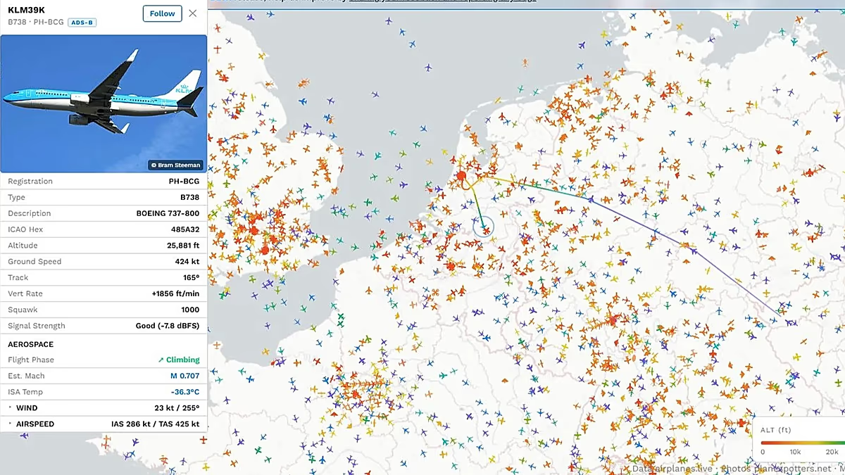
Human curiosity has always been drawn skyward, but in our digital age, this timeless fascination has manifested in a remarkably modern and highly addictive global hobby: watching the world’s airspace in real-time. Whether it was tens of millions of people collectively holding their breath as they followed the final, somber journey of Queen Elizabeth II from Edinburgh to London, or anxious families tracking the very first commercial flights rising safely out of the United Arab Emirates against the tense, unfolding backdrop of historical geopolitical conflicts, flight tracking has transitioned from a niche interest into a powerful, mainstream cultural phenomenon. There is something deeply human and comforting about watching a tiny, digital airplane icon traverse a glowing screen; it represents hundreds of living souls, each with their own unique lives, destinations, and families, navigating the vast and challenging atmosphere. Whenever global events shift, our collective protective instinct is to look upward, seeking clarity amidst international chaos, which is why so many of us find solace in “monitoring the situation” from the comfort of our homes. Recognizing this profound human drive and the rapidly growing community of internet sleuths and aviation lovers, the prominent news website Simple Flying has officially launched a highly advanced and beautifully designed flight tracking platform. This newly unveiled tool is engineered not simply to coexist with established industry giants like Flightradar24, but to fundamentally enrich and customize how we interact with the skies above us. By blending sophisticated, real-time data tracking with a highly accessible, clean website interface, this platform serves as a virtual window into the world’s busiest aerial highways. It invites casual vacation planners, anxious family members, and hard-core investigators alike to participate in a shared, daily journey of geographic exploration, reminding us of how profoundly connected our globalized society truly has become. Ultimately, it turns raw skywatching into a shared human experience.
What truly sets this newly launched tracker apart from long-standing competitors is its brilliant focus on proactive observation, particularly through a state-of-the-art emergency alert system designed to instantly highlight unusual or anomalous activity in the skies. In the past, identifying a mid-air emergency required a mix of rare luck, constant manual scanning, and monitoring third-party aviation forums, but this new platform dynamically changes the game by automatically flagging flights that exhibit erratic behaviors. It monitors complex, fine-tuned metrics such as sudden altitude oscillations—where a plane rapidly climbs or drops outside of its standard flight plan due to severe turbulence, sudden weather patterns, or rapid cabin depressurization—as well as highly erratic flight paths that suggest a pilot is navigating around severe storms or managing a sudden technical difficulty. It also closely analyzes unusual aircraft turn rates, which can indicate an immediate holding pattern, a swift tactical maneuver, or an urgent diversion to the nearest available emergency runway. Most excitingly for those who closely follow aviation developments, the tracker features instant system alerts for specific aviation squawk codes. These special transponder codes are universal, four-digit numbers used by pilots to communicate critical security or medical emergencies directly to air traffic control without needing to speak. A prime example is “Squawk 7700,” the international distress signal indicating a general in-flight emergency, which instantly alerts users that an airplane’s crew is actively managing a serious situation onboard. By automating the detection of these high-stakes events, Simple Flying’s tool empowers everyday internet users with the exact same real-time operational awareness that was once reserved solely for professional air traffic controllers, dispatchers, and airline operations centers, elevating public safety monitoring to an art form. It bridges the gap between fear and understanding, helping us comprehend the immense bravery and technical skill pilots demonstrate daily.
Beyond the high-adrenaline thrill of emergency monitoring, this newly designed platform offers an incredibly rich, interactive playground of technical features that allow users to dive deep into the specific details of any active flight around the globe. Users can seamlessly track airplanes in real-time, watching their virtual markers glide across high-definition maps with fluid animations, or utilize an advanced playback feature to reconstruct a flight’s entire path from takeoff to landing long after the journey has safely concluded. Every single click on an active aircraft reveals a veritable goldmine of fascinating, highly specific data, including the precise make and model of the aircraft, the airline operator, the current groundspeed, geographical coordinates, actual altitude, and the exact rate of vertical climb or descent. Recognizing that aviation enthusiasts crave complete situational context, the development team has also integrated official Notices to Airmen (NOTAMs) directly into the interface, allowing users to read the same critical safety announcements, runway closures, and temporary airspace restrictions that actual commercial pilots must master before taking off. Furthermore, the tracker contains highly versatile filtering options, giving users the power to fully customize their viewing experience by isolating commercial airliners, heavy military transports, luxury private jets, and even ground-based airport surface vehicles moving along airport runways. For individuals who have a favorite aircraft type, such as the legendary Boeing 747, or wish to monitor a specific tail number, the platform features a customizable watchlist that triggers notifications whenever a selected callsign takes to the air. This masterful blend of deep technical data and highly user-friendly customization ensures that the tool is just as useful for serious investigative researchers as it is for casual vacationers waiting for their loved ones to touch down. It elevates tracking from a passive utility to an active journey of constant discovery.
Another deeply engaging and highly unique element of this newly launched tracker is its comprehensive, real-time statistics panel, which acts as a live, virtual scoreboard for global aviation movement. Rather than archiving data in sterile, hard-to-read spreadsheet databases, this panel actively processes and visualizes massive sets of telemetry to reveal fascinating key trends that would otherwise remain hidden to most casual observers. With a simple click, users can explore interactive graphs of altitude distribution, illustrating exactly how many commercial aircraft are cruising in different atmospheric layers at any given second, or immediately identify which global airline operators are dominating the skies at that exact moment. The dashboard also continuously updates a list of the most active civilian aircraft models currently in flight, allowing users to watch the ongoing operational balance between ubiquitous, short-haul single-aisle aircraft like the Airbus A320 and massive widebody aircraft that carry passengers across oceans. You can even observe how global aviation patterns dynamically shift between daytime and nighttime flight corridors, transforming standard airline routes into a pulsating geographic rhythm that mimics human behavior. For anyone who has ever looked up at a fading vapor trail in the bright blue sky and wondered about the vast, invisible networks connecting our distant cities, this statistics panel turns complex global logistics into an illustrative story of human movement and cooperation. It is, in every sense of the term, an aviation enthusiast’s absolute dream, converting raw geometric data into a gorgeous, easily digestible canvas of modern transport. By transforming cold, mathematical telemetry into an emotionally resonant visual narrative, the developers have succeeded in creating an educational tool that nurtures our shared, childhood wonder of flight, proving that statistical graphs can hold a sense of poetry. It captures the sheer scale of our global mobility, offering an awe-inspiring perspective of our collective carbon footprint and continuous connectivity.
While the front-end user experience of Simple Flying’s new tracker is incredibly polished, the real magic lies behind the digital curtain in how this immense quantity of global flight data is actually harvested, synthesized, and displayed in real-time. The platform pulls its geographical and positional intelligence from several highly respected, collaborative open-source databases, including the community-run platforms Airplanes.Live and OurAirports.com, showcasing the immense power of shared data networks over proprietary setups. The technology that makes this tracking miracle possible relies on two primary systems: Automatic Dependent Surveillance-Broadcast, commonly known as ADS-B, and Multilateration, which is abbreviated as MLAT. Most modern aircraft operating globally are equipped with specialized transponders that continuously broadcast their precise GPS coordinates, air speed, pressure altitude, and heading into the sky surrounding them at a frequency of 1090 MHz. These high-frequency radio waves are then intercepted by a vast, decentralized army of small, low-cost antenna receivers—often built using simple Raspberry Pi microcomputers—set up by passionate, independent aviation hobbyists located in backyards, balconies, and rooftops around the world. In areas where older aircraft do not broadcast GPS-based data, MLAT calculations take over, pinpointing the aircraft’s position by analyzing the microscopic, millisecond differences in the signal’s arrival times at multiple independent ground stations. What makes this technological infrastructure so inspiring is that it is entirely democratized and crowdsourced; anyone can purchase a small receiver kit, connect it to the internet, and contribute valuable tracking telemetry to the wider aviation ecosystem. This volunteer-fueled framework represents a stunning example of global digital community, where individual citizens across all continents voluntarily pool their resources to build a transparent, free map of our skies that keeps the public informed and connected. It proves that technology, when put in the hands of the community, can break down barriers and foster incredible cooperation.
Ultimately, platforms like this newly launched flight tracker represent far more than a passing digital novelty for aviation hobbyists; they are highly vital, transformative components of our modern, hyper-connected information age and the growing Open Source Intelligence (OSINT) movement. In a complex world where global news travels at lightning speed and misinformation can easily cloud our understanding of critical geopolitical events, having direct, unfettered access to transparent, real-time telemetry empowers ordinary citizens, investigative journalists, and environmental researchers to verify facts for themselves. Whether it is monitoring the environmental footprint of luxury private travel, following the heroic pathways of humanitarian air bridges delivering life-saving aid to disaster-stricken regions, or tracing sensitive diplomatic flights during historic peace negotiations, public flight trackers have become structural pillars of global truth and accountability. They effectively level the information playing field, ensuring that the activities happening throughout our collective atmosphere remain open to public inspection rather than locked away behind corporate or government firewalls. By combining beautiful design with high-end analytical functions, Simple Flying has created an educational bridge that invites all of us to step beyond our personal, local environments and engage with the global family in a deeply visual and interactive way. Even on a quiet night, staring at the screen and watching the sweeping lines of transatlantic flights reminds us that we are all interconnected travelers on this fragile blue marble. So, the next time you hear the distant, low rattle of a jet engine echoing from high above, you no longer have to wonder about its mysterious destination; with a simple click, you can join a global community of observers, connect with amateur radio hosts across the planet, and follow that flight safely to its final home. It is a striking testament to how we can navigate the future together, unified by shared data, visual stories, and boundless human curiosity.