

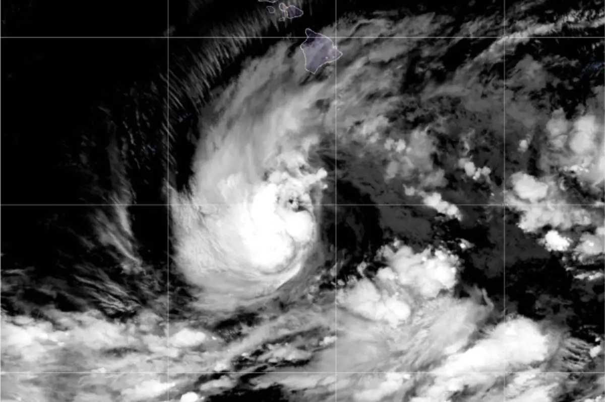
The weather maps this week look like something out of a disaster movie, especially if you live in the middle of the Pacific. Across a vast stretch of ocean that most people only see from an airplane, several tropical systems are churning at the same time. Tropical Storm Nolo, one of the most closely watched, is now moving toward the Hawaiian Islands with the potential to become a major hurricane. It is not alone. Hurricane Polo and Tropical Storm Odalys are also spinning in the Pacific, both on paths that could bring them close to Mexico. For people in Hawaii, however, Nolo is the storm that matters most. It sits southeast of the Big Island, in a part of the ocean where warm water and lighter winds are expected to help it intensify quickly. Forecasters at the National Hurricane Center are tracking it closely. The storm is currently about 300 miles from South Point, Hawaii. It has sustained winds of 40 miles per hour, which is not especially powerful, and it is moving slowly at just 6 mph. But that slow movement is part of the danger. A slow storm can sit over an island for a long time, dropping enormous amounts of rain. And conditions are expected to become much more favorable for development in the next couple of days. Residents in Hilo, Kona, and other communities know that hurricane season in the Pacific can be unpredictable. They have seen storms turn at the last minute, and they have seen storms arrive with little warning. This time, the entire state is paying attention because the forecast models have been unusually consistent. The FOX Forecast Center expects Tropical Storm Nolo to strengthen into a major hurricane by Saturday morning, just as it makes its closest approach to the islands. A major hurricane is a Category 3 or stronger, with winds of at least 111 mph. That is a very different beast from the 40 mph tropical storm that is currently out there. The National Hurricane Center has already issued a Hurricane Watch for Hawaii’s Big Island, which means hurricane conditions are possible. This is not a normal Tuesday. For many meteorologists, this is one of the most significant storm threats Hawaii has seen in years.
One of the most striking things about Nolo is how rare it is for a major hurricane to come this close to Hawaii. The islands sit in a part of the Pacific where the water is often a little too cool for very strong storms, and the prevailing winds usually push hurricanes away from land. That is why a direct hurricane landfall in Hawaii is so unusual. In fact, only a handful of hurricanes have ever made landfall in the state, and major hurricanes have mostly stayed far out to sea. The FOX Forecast Center has been careful to say that it remains uncertain whether Nolo will actually make direct landfall. There is still a chance the storm could wobble, weaken, or take a more southerly track. But the fact that forecasters are even talking about a direct hit by a major hurricane is alarming enough. The storm is currently about 300 miles from South Point, Hawaii. While that may sound far, it is not far at all in hurricane terms. A large storm can affect weather hundreds of miles from its center, and the outer bands of rain and wind can arrive long before the eye does. Hurricane force winds extend outward from the center, and tropical storm force winds can cover an even larger area. So even if the exact center of Nolo stays offshore, the Big Island will feel the effects. The Hurricane Watch issued by the National Hurricane Center covers the Big Island, and more watches or warnings could be issued as the storm gets closer. The next 24 to 48 hours will be critical. Hurricane hunters are scheduled to fly into the storm Thursday afternoon to gather more data, and their findings will help forecasters refine the track and intensity forecasts. Until then, residents are being told to prepare for the possibility of a powerful and destructive storm. The uncertainty is the hardest part for ordinary people. It is easier to prepare for a storm that is coming straight at you than for one that might veer away at the last second, and that uncertainty weighs heavily on everyone involved.
For all the concern about wind speeds, the most dangerous and life-threatening part of this storm is likely to be the rain. The forecast calls for heavy rainfall to begin Thursday and continue through the weekend. On the Big Island, total rainfall amounts are expected to be around 8 to 12 inches, with 19 to 24 inches possible on the eastern side of the island. Some localized areas could see more than 30 inches by the time the storm finally moves away. To put that in perspective, many places in the continental United States receive less than 30 inches of rain in an entire year. Hawaii’s mountains and windward slopes are especially vulnerable to extreme rainfall, because the terrain forces the moist air upward, creating persistent bands of rain that can linger for hours or even days. This is exactly the kind of setup that produces catastrophic flash flooding and debris flows. Flood Watches are already in effect for more than half of the main Hawaiian Islands, including the Big Island, Maui, Molokai, Lanai and Kahoolawe. That means conditions are favorable for flooding, and flooding could become life-threatening. NOAA has been unusually blunt about the danger, warning that life-threatening, catastrophic flooding and mudslides are possible. For residents, that means more than just a few closed roads. It means fast-moving water, landslides, and the risk of being stranded. The time to prepare is now, before the rain starts. People are being urged to clear drainage ditches, secure loose items, stock up on food and water, and make plans for evacuation if necessary. Emergency managers on the Big Island have been using every channel they can to spread the message: do not wait until the water is rising to act.
Forecasters are also comparing this storm to Hurricane Lala, which made a close approach to Hawaii earlier in the season. The predicted rainfall for Nolo is very similar to what Lala was expected to bring, and that comparison is not comforting. Lala reminded everyone that even a storm that does not make landfall can cause serious destruction through rain and flooding. But Nolo could bring another layer of danger: powerful wind gusts. The FOX Forecast Center expects the storm to produce winds over 70 mph, which is enough to down trees, knock out power, and damage roofs. On an island that relies heavily on tourism and has limited infrastructure, power outages can have cascading effects. Water pumps stop working, gas stations cannot pump fuel, cell towers may go dark, and medical facilities could lose critical equipment. Wind of that strength also turns everyday objects into flying projectiles. Grills, patio furniture, potted plants, and roof tiles can become dangerous debris. That is why officials are asking residents to secure anything that could be blown around. In the middle of all this uncertainty, hurricane hunters are doing their best to understand the storm. These specialized aircraft fly directly into the storm, releasing instruments that measure pressure, wind, and moisture. Their data is critical for improving forecasts. Thursday afternoon’s flight into Nolo will give forecasters a much better idea of how strong the storm has become and how quickly it is intensifying. It will not tell them exactly where the storm will go, but it will help reduce some of the uncertainty, giving residents and emergency managers more confidence about their decisions. Every flight into a storm is also a reminder that there are real people behind the forecast numbers, risking turbulence and discomfort to protect communities they may never meet.
Tropical Storm Nolo is not the only storm worth watching. Across the Pacific, Hurricane Polo and Tropical Storm Odalys are barreling toward Mexico, and they are a reminder that this is an exceptionally active stretch of weather. The ocean is full of heat and moisture this year, and the atmosphere is responding with one storm after another. For people in Hawaii, it can feel unfair to have to deal with Nolo while watching other storms churn elsewhere. But the conditions in the Pacific are not easing up. The same warm waters that are fueling Polo and Odalys are also helping Nolo. Forecasters have noted that Nolo is entering a much more favorable environment for development, with lower wind shear and warmer sea surface temperatures. That is the meteorological equivalent of pouring gasoline on a fire. A storm that might have stayed weak can quickly become a monster when conditions are right. The broader picture is one of a planet in motion: ocean currents, trade winds, and weather systems all interacting in ways that can be hard to predict. For the people who live in these regions, the experience is deeply personal. Families in Mexico are preparing for Polo and Odalys just as families in Hawaii are preparing for Nolo. In an age of global communication, the images of storm prep in Hilo and Acapulco can feel connected. It is also a good reminder that hurricanes do not respect political borders. They are natural events that affect everyone in their path, and they can be especially dangerous for communities that are not used to direct hits. Hawaii has a strong emergency management system, but it remains vulnerable because of its isolation. Help cannot arrive quickly; supplies take time to transport; and the entire state is essentially one island chain in the middle of the ocean. That is why preparedness matters so much, and why people are taking this storm seriously even before the first raindrops fall.
As the storm approaches, the mood in Hawaii is a mix of anxiety and resolve. There is a certain rhythm to preparing for a hurricane: checking the weather app, filling the bathtub with water, buying canned goods, moving the car to higher ground. It is not glamorous, but it is necessary. NOAA has said it clearly: the time to prepare for significant heavy rain and flooding impacts on the Big Island is now. When the rain begins Thursday and Friday, there will be little time to make up for lost preparation. Life-threatening, catastrophic flooding and mudslides are possible. Those are strong words, and people are taking them seriously. Neighborhoods on the east side of the island are especially concerned because they are expected to see the worst of the rainfall. Community centers and schools are being used as shelters. Sandbag distribution points have been set up. People are checking on their elderly neighbors, securing boats, and making sure they have enough medication for several days. It is a stressful time, but it is also a time when the best of humanity shows up. Hurricanes have a way of forcing people to come together. In the end, no one can control the weather. We can only control how we respond to it. The hope is that Nolo weakens, turns away, or passes without catastrophic damage. But hope is not a plan. Preparation, community, and vigilance are the real tools. The hurricane hunters will fly, the forecasters will update their models, and the residents of Hawaii will keep watching the sky. Whatever happens, they will face it together, as island communities have always done.