



Echoes Across the Pacific: Powerful 7.3-Magnitude Earthquake Strikes Off the Coast of Mexico
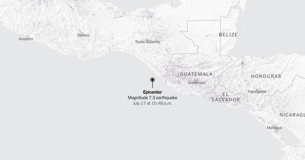
The volatile tectonic boundaries of the Pacific Rim made their presence felt once again on Friday morning when a powerful 7.3-magnitude earthquake ruptured beneath the North Pacific Ocean, sending shockwaves toward the western coast of Mexico. According to real-time seismic monitoring data released by the United States Geological Survey (USGS), the massive undersea temblor struck at exactly 10:48 a.m. Eastern Time. The epicenter of the marine disturbance was pinpointed approximately 30 miles southwest of Aquiles Serdán, a coastal community situated in a region historically accustomed to the violent shifts of the Earth’s crust. While early automated readings briefly classified the event as a magnitude 7.4 earthquake, subsequent analysis by government seismologists refined the measurement to a still-formidable 7.3 magnitude. Despite the offshore origin of the seismic rupture, the sheer energy released by the event sparked immediate concern among emergency management agencies, seismologists, and coastal residents, drawing global attention to the geological vulnerability of Central America’s Pacific coastline.
   PACIFIC OCEAN

             ▲ Epicenter (7.3 Magnitude)
           * [30 Miles SW of Aquiles Serdán]
            __________________________
                        |
                        |   MEXICO
                        |  [Aquiles Serdán]
In the frantic minutes following the initial rupture, scientific agencies scrambled to assess the potential for widespread destruction and the threat of localized tsunamis. Undersea earthquakes of this magnitude possess the displacement capacity to move massive columns of seawater, often triggering ocean-wide alerts. Initial maps generated by the USGS highlighted a broad perimeter of intensity, focusing primarily on zones experiencing a Modified Mercalli Intensity level of 3 or higher. Though the federal agency standardizes a level 3 vibration as “weak” shaking—reminiscent of the passing of a light truck—the geographic reach of such a substantial event means its vibrations can easily register in tall buildings and quiet rooms hundred of miles away, bypassing immediate structural damage but serving as a stark reminder of the subterranean forces at play. Because seismic waves dissipate over distance and depth, the oceanic buffer between the epicenter and the Mexican mainland thankfully absorbed the brunt of the kinetic discharge, limiting the immediate devastation that a comparable terrestrial event would have guaranteed.
As is customary with significant offshore earthquakes, the scientific community emphasizes that early reports remain subject to ongoing revision as more comprehensive telemetry arrives from global monitoring stations. Seismologists tasked with reviewing the event’s raw data continuously recalibrate their models, incorporating deep-sea sensor logs and coastal tide gauge readings to construct a definitive picture of the fault slip. This analytical refinement often leads to minor adjustments in both the recorded magnitude and the calculated depth of the focus, which in turn influences the official shake-severity maps utilized by humanitarian aid organizations and engineering researchers worldwide. The dynamic nature of earthquake source parameters means that the public warning systems and impact assessments updated by the USGS in the hours following the event represent a living scientific ledger, evolving as the earth gradually settles back into equilibrium.
====================================================================
SEISMIC PROFILE & KEY DATA
- Date of Event: Friday, July 17
- Origin Time: 10:48 a.m. Eastern Time (EST)
- Preliminary Magnitude: 7.4 (Downgraded to 7.3 upon review)
- Epicenter Location: 30 Miles Southwest of Aquiles Serdán, Mexico
- Primary Source: United States Geological Survey (USGS)
-
Population Data: Provided via Oak Ridge National Laboratory (LandScan)
To understand the broader implications of this North Pacific tremor, researchers rely on a combination of historical tectonic data and advanced geospatial modeling tools. Population density metrics gathered by LandScan, a global database managed by the Oak Ridge National Laboratory, were quickly cross-referenced with the earthquake’s propagation path to evaluate the human vulnerability index of nearby coastal settlements. By overlaying the Modified Mercalli Intensity scale onto these population heat maps, disaster response coordinators can quickly identify populated zones most vulnerable to slope failures, mudslides, or structural compromises. Fortunately, the remote coordinate of this oceanic epicenter, coupled with its placement off the rugged shoreline of western Mexico, suggests a low probability of high-density human exposure to destructive ground acceleration, though aftershocks remain an active concern for nearby maritime operations and coastal infrastructures.
The immediate aftermath of a magnitude 7.3 earthquake is rarely a singular event; rather, it marks the beginning of a prolonged period of crustal readjustment characterized by a cascade of secondary tremors. Geodesists monitoring the region noted that aftershocks began propagating along the fault plane almost immediately, prompting continuous updates to tracking charts representing seismic activity within a 100-mile radius of the primary rupture. Over the seven days following such a massive release of energy, smaller earthquakes—some reaching magnitudes capable of being felt on land—are expected to continue shaking the seabed. These secondary events are monitored meticulously, as they provide critical data regarding the stress redistribution along the North American and Cocos tectonic plates, a high-stakes geological boundary responsible for some of the most historic earthquakes in Latin American history.
As coastal communities resume normal activity and maritime vessels navigate the waters near Aquiles Serdán, the Friday morning earthquake stands as a powerful testament to the value of rapid, open-access science. The collaboration between the USGS, international oceanographic institutions, and advanced geospatial databases ensures that critical safety information is disseminated to the public within minutes of a deep-sea emergency. While this particular North Pacific event appears to have spared Mexico from a catastrophic disaster, the high-density monitoring systems and public awareness campaigns established along these fault lines remain our most reliable shield against the unpredictable, violent whims of a living planet.