




A Sudden Tremor in the Pacific: Mid-Day Earthquake Rattles the Coast of Central Chile
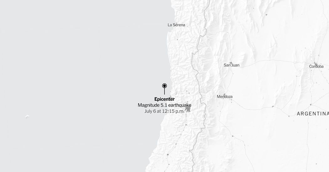
SANTIAGO, Chile — A sharp, moderately strong earthquake jolted the coastal shelf of central Chile on Monday afternoon, sending brief tremors through coastal towns and signaling yet another reminder of the region’s intense seismic volatility. According to official data released by the United States Geological Survey (USGS), the magnitude 5.1 temblor struck beneath the cold waters of the South Pacific Ocean, registering at exactly 12:15 p.m. Chile Standard Time. The epicenter was located approximately 35 miles west of La Ligua, a historic provincial city in the Valparaíso region renowned for its vibrant textile tradition and agricultural valleys. Though situated deep beneath the ocean floor, the event was felt by localized coastal populations, highlighting the delicate relationship between Chile’s bustling shoreline communities and the active tectonic margins that lie just miles off its picturesque coast.
While the initial shock waves caused unexpected moments of anxiety for local residents during their lunch hour, early telemetry indicates the direct impact remained largely manageable. The USGS shake-severity mapping models categorized the coastal vibrations as “weak to light” on the Modified Mercalli Intensity Scale, specifically indicating a shake intensity rating of 3 or greater for the immediate areas closest to the offshore epicenter. Under this standardized system, a level 3 intensity is characterized by vibrations akin to the passing of a light truck, often unnoticed by people in motion but distinctly felt by those sitting quietly indoors. Although the map defines this zone of influence conservatively, seismological history shows that maritime events in this corridor frequently ripple outward, occasionally making their presence felt in high-rise apartments as far away as the capital city of Santiago, situated some 100 miles to the southeast.
+—————————————————————–+
| SEISMIC EVENT SUMMARY |
+—————————————————————–+
| Date / Time | Monday, July 6 at 12:15 PM (Chile Time) |
| Magnitude (Mw) | 5.1 (Moderately Strong) |
| Epicenter Location | 35 miles West of La Ligua, Chile |
| Coordinate Region | South Pacific Ocean (Valparaíso Shelf) |
| Primary Intensity | III (Weak) on Modified Mercalli Scale |
| Data Sources | USGS, LandScan (Oak Ridge National Lab) |
+—————————————————————–+
Geological agencies emphasize that the rapid parameters released in the immediate aftermath of such events are subject to ongoing refinement. As seismologists pull comprehensive telemetry from regional broadband stations and analyze secondary wave arrivals, they routinely review and revise the magnitude and depth estimates of offshore earthquakes. Consequently, the initial 5.1 calculation may undergo slight adjustments as more sophisticated calculations emerge. Furthermore, detailed data collected by regional instruments regarding localized peak ground acceleration will allow USGS scientists to dynamically update their shake-severity assessments, providing emergency response planners and municipal engineers with a highly accurate picture of how soil density and topography may have amplified or dampened the seismic energy along the Valparaíso coastline.
To understand why this specific stretch of the South Pacific is continuously subject to sudden ruptures, one must look at the grand tectonic architecture of the South American continent. The Chilean coast sits directly atop the boundary of one of the planet’s most aggressive subduction zones, where the dense oceanic Nazca Plate slides beneath the lighter continental South American Plate at an average rate of about several centimeters per year. This persistent collision bends and deforms the Earth’s crust, locking immense slabs of rock together until they suddenly snap to release accumulated stress. This geodynamic engine, part of the notorious circum-Pacific “Ring of Fire,” has generated some of the most catastrophic earthquakes in recorded human history, including the legendary 1960 Valdivia earthquake, making continuous seismic monitoring an absolute necessity for Chilean society.
To construct a highly detailed assessment of how these events interact with local human geography, researchers pair live seismic readouts with global population databases, such as the LandScan dataset developed by the Oak Ridge National Laboratory. By overlaying real-time shake maps onto precise population density grids, disaster management groups can instantly identify which communities are most vulnerable to earth movements. In the case of Monday’s earthquake off La Ligua, the rural-urban balance of the Valparaíso region—characterized by concentrated coastal tourist strips, fishing villages, and interior agricultural communities—means that even minor shifts in an earthquake’s epicenter can significantly alter the number of citizens exposed to high-velocity ground motion.
Ultimately, this localized mid-day disturbance serves as a quiet but potent reminder of the resilience required of those who live along the Chilean margin. It highlights the critical, silent work performed by global monitoring bodies and local emergency services who track, map, and translate complex geological telemetry in real time. Thanks to decades of strict building codes, comprehensive public drills, and advanced early-warning infrastructure, Chileans have cultivated a unique culture of preparedness, allowing communities like La Ligua to absorb these moderate tectonic jolts with calm and structured composure. As the seabed settles and the scientific community continues to analyze the aftershock sequences within a 100-mile radius of the primary rupture, life along the South Pacific coast moves forward, balanced gracefully atop the restless forces of the Earth.