Atlantic Disturbance Chances Downgraded as Hurricane Season Continues
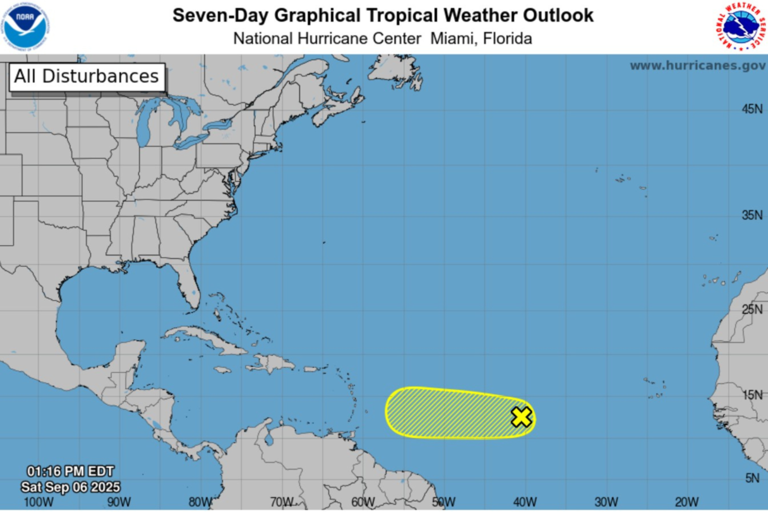
The National Hurricane Center (NHC) significantly reduced the development chances for a tropical wave in the central Atlantic on Saturday afternoon, marking a notable shift in forecasters’ expectations. The system, designated as Invest 91L, had been previously anticipated to develop into Tropical Storm Gabrielle, but its formation probability dropped to just 20 percent. This reduction represents a dramatic change from earlier in the week when models showed much higher odds of development. The downgrade came as forecasters observed a limited area of thunderstorm activity within the wave and noted intrusions of dry air hampering the system’s organization. Despite the lower chances, the tropical wave continues moving westward at 10 to 15 mph and is expected to approach the Lesser Antilles by the middle of next week, prompting officials to advise residents in the region to monitor its progress.
The diminishing prospects for Invest 91L come during what was predicted to be an active Atlantic hurricane season. Last month, the National Oceanic and Atmospheric Administration (NOAA) forecasted 13 to 18 named storms and several hurricanes during the peak season from August through October. So far this year, the Atlantic has been relatively quiet, with only one storm—Hurricane Erin—reaching hurricane strength, though it never made landfall. If Invest 91L were to develop against the odds, it would become the season’s seventh tropical cyclone and receive the name Gabrielle. However, even if development occurs, forecasters describe the environmental conditions in its path as “only marginally conducive,” with inconsistent model predictions regarding its potential track and intensity, creating uncertainty about its future.
The changing forecast highlights the challenges of tropical weather prediction, particularly during peak hurricane season. Earlier outlooks had generated concern for both the northeastern Caribbean islands and potentially the United States, as some models had shown formation chances as high as 90 percent. This dramatic shift underscores how quickly tropical forecasts can change as new data becomes available and environmental conditions evolve. In the updated outlook, the NHC cited specific factors reducing development potential, including dry air intrusions and limited thunderstorm activity—essential components for tropical cyclone formation. “Environmental conditions are only marginally conducive for development, and the chances of this system becoming a tropical depression continue to diminish,” stated Forecaster Roberts in Saturday’s tropical outlook from the NHC.
For residents of the Lesser Antilles, including the Leeward Islands, Virgin Islands, and Puerto Rico, the system still bears watching despite its reduced chances of strengthening. Local officials continue to encourage residents to stay informed through official channels as the wave approaches their region by midweek. Andrew Hazelton, associate scientist at the University of Miami’s Cooperative Institute for Marine and Atmospheric Studies, noted to USA TODAY that “For a while, it appeared an atmospheric pattern farther north in the Atlantic might pick up the system and take it out to sea,” highlighting how global atmospheric patterns influence these systems. The uncertainty surrounding Invest 91L serves as a reminder that hurricane preparedness remains essential even when development chances appear low, as conditions can change rapidly in the tropical Atlantic.
While the immediate threat from this particular system has diminished, the 2023 Atlantic hurricane season remains in its most active period, with several months to go before the official end on November 30th. Historically, September has produced some of the most powerful Atlantic hurricanes, and forecasters maintain that overall seasonal conditions favor above-average activity. Despite the quieter-than-expected season thus far, meteorologists continue to emphasize that it only takes one significant storm making landfall to create devastating impacts. The reduced probability for Invest 91L provides temporary relief for communities potentially in its path but doesn’t change the overall seasonal outlook or the need for continued vigilance.
For meteorologists and emergency management officials, systems like Invest 91L represent the challenging nature of tropical forecasting, where environmental factors can rapidly enhance or suppress development. The current forecast illustrates how dry air—often originating from the Saharan Desert—can inhibit tropical development by disrupting the thunderstorm activity necessary for cyclone formation. As forecasters continue monitoring the central Atlantic, they’re also watching for other potential development areas typical during September, including the western Caribbean and Gulf of Mexico, where warm waters could support rapid intensification if a system were to organize. While Invest 91L may not develop as initially anticipated, the ongoing hurricane season demands continued attention from coastal residents and emergency planners alike, with each tropical wave offering valuable data to improve future forecasts and preparation strategies.


