Hurricane Katrina: 20 Years Later – Lessons Learned and Challenges Ahead
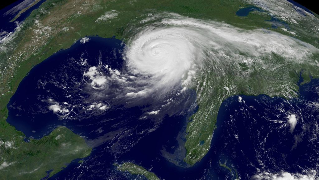
In late August 2005, Hurricane Katrina unleashed its fury on the U.S. Gulf Coast, carving a path of unprecedented destruction through Louisiana, Mississippi, and Alabama. What began as a tropical storm rapidly transformed into one of America’s deadliest and costliest natural disasters. Powerful storm surges overwhelmed the levee system meant to protect New Orleans, submerging approximately 80 percent of the city under floodwaters. The human toll was devastating—more than 1,800 lives lost, hundreds of thousands displaced from their homes, and property damage estimated at $125 billion. Two decades later, Katrina remains tied with 2017’s Hurricane Harvey as one of the two most expensive Atlantic hurricanes in recorded history. The catastrophe exposed critical vulnerabilities in America’s disaster preparedness systems and prompted a national reckoning about how we forecast, prepare for, and respond to major hurricanes.
Katrina’s development into a catastrophic hurricane followed a rapid and unexpected trajectory. On August 25, 2005, it was merely a Category 1 hurricane crossing Florida, but everything changed when it entered the Gulf of Mexico. There, Katrina encountered extraordinarily favorable conditions—a 100-meter-thick layer of warm water averaging 26 degrees Celsius—providing perfect fuel for intensification. Initially forecast to curve back toward the Florida panhandle, the storm instead continued westward, rapidly strengthening from a Category 3 hurricane to a terrifying Category 5 monster within just 12 hours. Wind speeds surged from 185 to 265 kilometers per hour, catching forecasters and emergency planners by surprise. This dramatic intensification exemplifies one of the greatest challenges in hurricane forecasting: predicting not just a storm’s path, but also how quickly it might transform into a major hurricane. The disaster that followed revealed glaring gaps in America’s emergency response capabilities. Federal aid arrived too slowly and in insufficient quantities. Evacuation orders came less than 24 hours before landfall—too late for many residents—and there simply wasn’t enough shelter, food, or water for those left stranded. The Federal Emergency Management Agency (FEMA), later admitted being “woefully inadequate” in its logistics capabilities to handle a disaster of Katrina’s magnitude.
Significant progress has been made in hurricane forecasting since Katrina, driven by technological advances and dedicated research programs. Better and more frequent observations, particularly from satellite remote sensing, provide crucial data multiple times daily on atmospheric conditions. More powerful computers and improved understanding of atmospheric physics enable meteorologists to transform these observations into increasingly accurate predictions. Hurricane Hunter aircraft flights into storms have significantly reduced forecast track errors—by up to 24 percent according to recent studies. High-resolution satellite imagery from NOAA’s GOES-16 satellite (launched in 2017) and the Department of Defense’s weather satellites allow scientists to penetrate cloud layers, revealing a storm’s internal structure and potential for strengthening. Following the devastating 2004-2005 hurricane seasons, the National Hurricane Center launched the Hurricane Forecast Improvement Project (HFIP) in 2007, an ambitious collaborative effort to enhance hurricane track and intensity forecasts. The results have been remarkable: track forecast errors have improved by over 50 percent, meaning a four-day hurricane path prediction that might have been off by 300 kilometers in the early 2000s now has an error margin of only about 200 kilometers—the difference between accurately warning a city or missing it entirely.
These improvements in forecasting technology translate directly into saved lives and reduced economic damage. An analysis of over 30 hurricanes that made landfall in the U.S. between 2005 and 2022 shows that improved forecasts beginning around 2007 reduced hurricane costs by approximately 19 percent—saving about $2 billion per storm. This represents an extraordinary return on investment, considering the Hurricane Forecast Improvement Program cost only about $300 million over a decade. In 2022, NOAA unveiled its next-generation hurricane model, the Hurricane Analysis and Forecast System, capable of tracking multiple tropical storms simultaneously. This innovation allows researchers to observe how storms influence each other, improving intensity predictions by up to 30 percent. Better forecasts give communities precious additional days to prepare—time that can be used for evacuations, installing temporary flood protection, deploying emergency generators to hospitals, and securing vulnerable infrastructure. While four days isn’t enough time for major infrastructure projects like rebuilding protective wetlands or raising seawalls, it does provide a critical window for short-term protective measures that significantly reduce both casualties and economic losses.
Despite these advances, climate change threatens to erase many of these gains by making hurricanes less predictable and more dangerous. As Earth’s climate warms, hurricanes are becoming larger, rainier, penetrating farther inland, and—most alarmingly—more likely to undergo explosive intensification. Analysis of tropical cyclone data from 1971 to 2020 reveals that the number of Atlantic storms rapidly intensifying from Category 1 to Category 3 or higher within 24 hours has more than doubled. This rapid strengthening gives communities less time to prepare, potentially negating the benefits of improved forecasting. Rising ocean temperatures fuel this concerning trend: Gulf of Mexico sea surface temperatures have increased by about 1 degree Celsius since the 1950s, providing more energy for hurricane development. The Atlantic’s unusually warm waters intensified devastating hurricanes like Harvey and Maria in 2017, offering a preview of what may become increasingly common. Climate models project annual disaster losses to double in many Gulf Coast states by 2050, with projected yearly losses of $32 billion under a “middle-of-the-road” warming scenario compared to $15 billion if global warming weren’t factored in. The challenge is compounded by the frequency of storms hitting the same regions: “A large part of the Gulf has gotten hit again and again,” notes researcher Andrew Rumbach. “It’s really difficult to recover once. It’s more difficult to recover multiple times.”
As we mark the 20th anniversary of Hurricane Katrina, the United States stands at a crossroads in hurricane preparedness. While forecasting technology has made remarkable strides, proposed budget cuts threaten to undermine this progress. Looming reductions to NOAA’s budget could eliminate funding for crucial satellites, storm observations, and staff. The Hurricane Hunter program faces an uncertain future, with many positions potentially eliminated in early 2025. The Department of Defense initially announced it would stop providing weather satellite data to NOAA after June 2024—a decision later postponed to September 2026, but still creating uncertainty about long-term data availability. Additionally, the administration has proposed dramatic cuts to FEMA, including the possibility of eliminating the agency entirely. In August 2024, 191 current and former FEMA employees signed the “Katrina Declaration,” warning Congress that the agency’s “current trajectory reflects a clear departure” from post-Katrina reforms. Environmental economist Renato Molina argues that what would truly reduce future hurricane costs would be long-term adaptations like seawalls and wetland restoration—investments that could double the savings per hurricane. Hurricane scientist Jeff Masters emphasizes the importance of continued investment in hurricane research: “The data clearly show that it makes sense to continue our investments in hurricane research, which have brought about these huge advancements in forecast accuracy. But given the multiple losses in forecasting capability that have occurred this year, this progress may halt or even reverse beginning in 2025.” This timing is particularly concerning as climate change increases the likelihood of rapidly intensifying hurricanes—”the most dangerous types of hurricanes” that give coastal communities little time to prepare or evacuate.


