



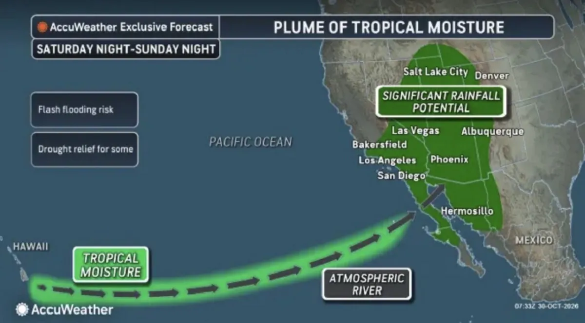
Imagine this: Halloween weekend is almost here, pumpkins are glowing on porches, kids are planning costumes, and the weather map is starting to look like something out of a storm-chasing documentary. Across the southwestern United States, forecasters are tracking a developing weather system that could bring heavy rain, flash flooding, and mountain snow right in the middle of all the holiday excitement. AccuWeather meteorologists have released a map showing a plume of tropical moisture being pulled toward the West Coast, and it has the potential to deliver a significant soaking to several states. Arizona, Utah, New Mexico, and Colorado are already bracing for renewed flooding, which is especially concerning because some of those areas have been hit hard by rain in recent days. The ground is saturated, rivers are running high, and more precipitation could push things over the edge. Southern California is also in the picture, though forecasters are quick to point out that the outcome there is far from certain. The amount of rain that falls in Los Angeles, San Diego, or Palm Springs will depend on how two separate storm systems interact with a stream of tropical moisture moving across the Pacific. If they stay apart, the region might see only light rain. If they merge, things could get much wetter. This is a classic late-October weather puzzle, and the pieces are still moving. The map itself is striking: a long plume of moisture stretching from the tropics toward the West Coast, with colors indicating where the heaviest rain could fall. It’s the kind of image that makes you appreciate how connected our weather is to the wider world. It’s also a reminder that the West is no stranger to dramatic weather swings, especially when an atmospheric river—a long, narrow corridor of concentrated water vapor—sets its sights on the coast. The next few days will tell the story, but for now, the forecast is one that deserves attention.
To understand what’s driving all this, it helps to know a little about atmospheric rivers. These are long, narrow corridors of concentrated water vapor that move through the sky like invisible rivers, carrying enormous amounts of moisture from tropical regions toward cooler land. The National Oceanic and Atmospheric Administration, or NOAA, sometimes calls them “rivers in the sky,” and the name fits: a single strong atmospheric river can transport more water than the flow at the mouth of the Mississippi River, though in vapor form rather than liquid. When one of these plumes originates near Hawaii, it’s known as a Pineapple Express—a term that sounds almost cheerful, like a tropical drink or a beach vacation. But the weather it brings can be anything but gentle. As the moisture-laden air reaches the West Coast, it encounters mountains and existing weather systems. The air is forced upward, cools, and condenses into clouds, releasing its moisture as rain and snow. That can produce prolonged periods of heavy precipitation, with rain falling for hours or even days. In the mountains, the same system can dump several feet of snow at higher elevations, which is great for ski resorts and water supplies but dangerous for travelers. The hazards don’t stop there. Heavy rain can overwhelm urban drainage systems, turn dry washes into raging rivers, and cause flash flooding in places that don’t usually see much water. Steep slopes, especially those scarred by recent wildfires, are vulnerable to mudslides and debris flows because fire-damaged soil doesn’t absorb water well. At the same time, these systems are not all bad. The western United States has been dealing with drought for years, and atmospheric rivers are one of the main ways the region gets its big annual water supply. They replenish reservoirs, build snowpack, and green up landscapes that would otherwise be dry. The challenge is that they often deliver too much water too quickly, and the ground can only absorb so much. That’s why forecasters pay such close attention to the intensity and duration of the rain, not just the total amount. In fact, forecasters often talk about atmospheric rivers in terms of their “integrated water vapor transport”—a fancy way of saying how much water is moving through the sky at any given time. When that number is high, the potential for heavy rain and flooding rises accordingly.
The map from AccuWeather shows the potential development and movement of the system, and it reads like a weather lover’s dream—or a party planner’s nightmare, depending on your perspective. Two storm systems are expected to play a role in pulling tropical moisture toward the western United States. One is dropping down from Alaska, bringing cooler air and energy. Another is developing off the coast of Washington state, adding its own spin to the atmospheric circulation. Meanwhile, Tropical Rainstorm Olana, located near Hawaii, could feed extra moisture into the plume, turning an already complex setup into a true multi-part weather event. AccuWeather meteorologists say the more likely scenario is that the storms and their associated moisture remain somewhat separated as they move along the Pacific coast. Under that outcome, rainfall across major Southern California metropolitan areas—including Los Angeles, San Diego, and Palm Springs—would be limited, with most places receiving less than an inch. Some south- and west-facing mountain slopes, however, could receive up to 3 inches, which could cause localized problems in canyons and burn scars. But there’s another scenario, and it’s the one that keeps forecasters up at night. If the storms and tropical moisture combine earlier, they could form a larger, slower-moving system near the coast. That would bring heavier and more persistent rainfall to Southern California, increasing the possibility of widespread flash flooding. The difference between these two outcomes is not huge in terms of storm track, but it makes all the difference for residents. A shift of just a hundred miles could mean the difference between a damp weekend and a dangerous one. Forecasters are using computer models, satellite imagery, and weather balloons to track the moisture plume in real time, but there’s still uncertainty. They’re especially interested in how much energy the system picks up from the warm ocean waters and whether the jet stream will steer it inland or keep it offshore. The bottom line for Southern California is that everyone should stay tuned to updated forecasts, because the situation could change quickly. For Halloween parties, outdoor events, and trick-or-treating, that uncertainty is a challenge. But it’s also an opportunity to be flexible and have backup plans.
While Southern California’s fate is still uncertain, the Southwest is facing a more straightforward threat. From late this weekend into early next week, Arizona, Utah, New Mexico, and Colorado could see renewed flash flooding, debris flows, and substantial rises in rivers and streams. The AccuWeather forecast calls for rainfall totals of 1 to 2 inches across much of the region, but some upslope areas—particularly in central Arizona, southwestern Colorado, and Utah—could receive between 2 and 4 inches. The Local StormMax forecast, which represents the most extreme possible amount in isolated spots, is 7 inches. That would be a lot of rain under any circumstances, but it’s especially concerning because the ground is already saturated in many places. Parts of the San Juan Mountains in northern New Mexico and southern Colorado received 5 to 10 inches of rain over the previous week, leading to flooding and record streamflows at monitoring stations. The soil can’t hold much more water, so additional rainfall will likely run off quickly, filling creeks and rivers and potentially overwhelming low-water crossings. Cities like Phoenix and Flagstaff in Arizona, Durango in Colorado, and Farmington in New Mexico could all experience flooding downpours. For residents, this means taking precautions: clearing storm drains, moving valuables to higher ground, and avoiding driving through flooded roads. It’s easy to underestimate how quickly water can rise in the desert, especially after a long dry spell, but recent storms have already shown how vulnerable the region can be. Even areas that don’t get the heaviest rain could see impacts if the rain comes down in short, intense bursts, which is common in this type of setup. Wildfire burn scars are another concern. When rain falls on a burn scar, the lack of vegetation and the water-repellent soil can cause rapid runoff, turning small streams into debris flows that carry mud, rocks, and trees. Several recent wildfires in the Southwest have left such scars, and forecasters are watching those areas closely. The combination of steep terrain, loose soil, and heavy rain is a recipe for dangerous conditions. The National Weather Service will likely issue flash flood watches and warnings as the system approaches, and residents should pay close attention to those alerts. A watch means conditions are possible; a warning means flooding is happening or imminent. Knowing the difference can save lives.
The system’s reach extends far beyond the immediate flood zones. The Pacific Northwest is likely to see widespread showers as the storm systems move through, and higher elevations of the Rocky Mountains—including parts of Montana, Idaho, Wyoming, Colorado, and Utah—could receive significant snow. This is actually welcome news in many ways. Early-season snow helps build the mountain snowpack that acts as a natural reservoir for the West, supplying water to rivers and reservoirs well into the summer. Ski resorts are eager for a fresh base, and winter recreation enthusiasts are already dreaming of powder days. But the snow also brings hazards, especially for travelers. Mountain passes could become slick and dangerous, and road closures are possible over Halloween weekend. The combination of rain, snow, and saturated ground creates a layered set of risks that forecasters are trying to communicate clearly. Steep mountain slopes are more prone to mudslides, especially where wildfires have stripped away vegetation and left soil loose. Burn scars from recent fires are particularly vulnerable, and even modest rainfall can trigger debris flows in those areas. At the same time, the rain is not all bad. Many parts of the West are dealing with long-term drought, and every drop helps fill reservoirs and replenish groundwater. The challenge is that nature often delivers water all at once, and the landscape isn’t always able to absorb it quickly. That’s why forecasters keep emphasizing the difference between a beneficial rain and a destructive one: it’s all about intensity and duration. A slow, steady rain can be a gift; a sudden downpour on already wet ground can be a hazard. For those living in mountain communities, it’s a good idea to have chains or winter tires ready, keep an emergency kit in the car, and check road conditions before heading out. For anyone in flood-prone areas, the advice is similar: stay informed, have a plan, and don’t take unnecessary risks. The weather may be beautiful one moment and dangerous the next. It’s also worth noting that mountain snow can be a blessing for the water supply, but it can also make travel dangerous. If you’re planning to drive over mountain passes, check the forecast and carry extra supplies.
Forecasters are continuing to monitor the developing weather pattern, and they’ll have a much clearer picture as the weekend approaches. Weather forecasting is never a perfect science, and this particular setup has enough moving parts that even small changes in the atmosphere could alter the outcome. The timing and track of the storms, the exact position of the moisture plume, and how much energy the system gains from the ocean all play a role. For now, the message from meteorologists is simple: be aware, be prepared, and don’t let the holiday festivities distract you from the possibility of severe weather. If you live in the Southwest, check your flood risk, secure anything that could be washed away, and have a plan for getting to higher ground if needed. If you’re traveling through mountain areas, be ready for winter driving conditions and possible road closures. And if you’re in Southern California, keep an eye on updated forecasts—the difference between a dry Halloween and a wet one may come down to a few hundred miles of shifting storm tracks. It’s also worth remembering that weather is a community experience. When a storm like this threatens, neighbors help neighbors, and being prepared is one of the best ways to take care of each other. Check on elderly relatives, make sure friends know about the forecast, and don’t drive through flooded streets, no matter how shallow the water looks. AccuWeather and NOAA will continue to issue updates, and local National Weather Service offices will have the latest warnings and watches. The key is to stay flexible and not assume the forecast won’t change. Halloween weekend is supposed to be fun, but it’s also a time when weather can sneak up on you. A little preparation can go a long way. Ultimately, this is a story of weather’s power and unpredictability. It’s also a reminder that even in an age of advanced forecasting, nature still calls the shots. So enjoy the season, but stay weather-aware. The sky might have more in store than just ghosts and goblins this Halloween. In the end, the best response to a forecast like this is a mix of respect and readiness. The weather will do what it wants, but we can control how we prepare. So as you hang that skeleton on the porch or carve that pumpkin, take a moment to check the sky and the forecast. It might be the most important part of your Halloween weekend.