



Midday Tremor: 5.3-Magnitude Earthquake Strikes Near Costa Rica’s Pacific Coast
A Sudden Shake on the Pacific Coast
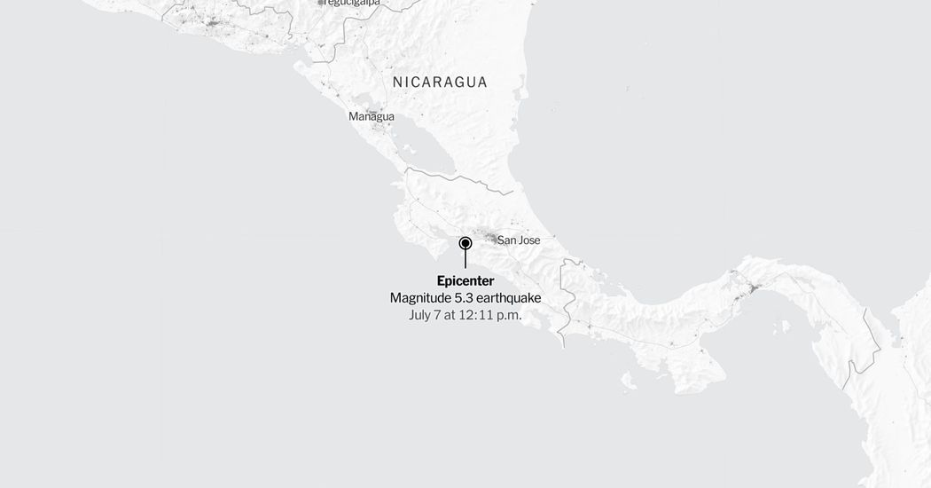
At exactly 12:11 p.m. Central time on a quiet Tuesday, a moderately strong 5.3-magnitude earthquake abruptly disrupted the midday routine across parts of Costa Rica, sending a physical reminder of the region’s intense geological activity through the ground. According to early data compiled and released by the United States Geological Survey (USGS), the seismic event was centered approximately six miles southwest of Orotina, a bustling transit hub nestled in the Alajuela province. This strategic location sits just inland from the Gulf of Nicoya and serves as a vital gateway between the capital city of San José and the popular tourist destinations along the Central Pacific coast. The midday timing meant that businesses were open, schools were in session, and streets were active when the distinct, rumbling vibration began, drawing immediate attention from local residents, businesses, and emergency services as windows rattled and structures swayed.
   COSTA RICA SEISMIC EVENT MAP (USGS)

          [ Alajuela Province ]
                   |
                   v
   [Orotina] <--- 6 Miles ---> (EPICENTER)
     /
[San José] [Pacific Ocean]
(Slight Shaking) (Gulf of Nicoya)
Understanding the Seismic Footprint
In the immediate aftermath of the event, scientific agencies hurried to map the boundaries of the tremor’s reach. The USGS developed a preliminary shake-severity map indicating that a significant geographic area experienced a shake intensity of 3 or greater on the Modified Mercalli Intensity scale. While seismologists categorize a level 3 intensity as “weak” shaking—typically felt noticeably by people indoors, especially on upper floors of buildings, but rarely causing structural damage—the physical sensation can still be deeply unsettling for those in the immediate vicinity. Because seismic waves travel differently depending on local soil conditions, topography, and building designs, reports of the tremor quickly radiated outward from the epicenter near Orotina. While the official zone of perceptible shaking was concentrated around the central and western regions of the country, anecdotal reports on social media suggested that the vibration was felt quietly in high-rise buildings as far away as the sprawling San José metropolitan area.
| Detail | Earthquake Information |
|---|---|
| Magnitude | 5.3 |
| Date / Time | Tuesday at 12:11 p.m. Central Time |
| Epicenter Location | 6 miles southwest of Orotina, Costa Rica |
| Primary Agency | United States Geological Survey (USGS) |
| Shake Category | Modified Mercalli Intensity Scale 3+ (“Weak” to moderate) |
The Dynamic Nature of Earthquake Science
As is standard with all major lithospheric movements, the initial data released by monitoring agencies remains subject to ongoing refinement. Seismologists at both the USGS and local Latin American observatories continually review incoming telemetry from regional sensor networks, meaning that the earthquake’s reported magnitude of 5.3 could be adjusted slightly upward or downward in subsequent assessments. This continuous flow of real-time data also allows scientists to update their shake-severity models, providing local emergency management teams with a highly accurate picture of where the stress of the strike-slip or subduction movement was most heavily concentrated. To ensure complete clarity across borders, scientific bodies noted that while the local time of the event was shortly after noon in Central America, international databases registered the shake data as of Tuesday, July 7 at 2:26 p.m. Eastern time, with subsequent monitoring of potential aftershocks extending well into the evening.
Incoming Telemetry —> Data Review (USGS) —> Magnitude Refined
—> Shake Map Updated
—> Emergency Reports Filed
Living in the Ring of Fire
The occurrence of a moderate earthquake in this part of Central America is a vivid reminder of Costa Rica’s unique geography, situated directly atop the highly active boundary where the Cocos tectonic plate subducts beneath the Caribbean plate. This constant tectonic collision is the primary engine behind both the country’s breathtaking mountainous landscapes and its frequent seismological activity. For the residents of Alajuela and the surrounding coastal provinces, earthquakes are an accepted element of daily life, prompting the government to enforce some of the most stringent and successful seismic building codes in Latin America. Because of these robust structural standards, moderately strong tremors like this 5.3-magnitude event rarely result in the widespread devastation seen in less prepared regions, though they serve as critical real-world tests for local disaster response frameworks.
COCOS TECTONIC PLATE CARIBBEAN TECTONIC PLATE
(Subducting) (Overriding Plate)
======================== /========================
/
v v
[ SEISMIC ZONE ]
(Site of 5.3-Magnitude Quake)
Monitoring the Aftershock Window
As the dust settled on the initial afternoon scare, the focus of geophysical agencies shifted toward tracing and documenting the inevitable sequence of aftershocks. Using advanced population density data, such as the LandScan model developed by the Oak Ridge National Laboratory, researchers are able to overlay the physical footprint of the seismic waves onto local communities to estimate potential impacts and direct aid if necessary. Historical data shows that when aftershock tracking is initiated, mapping systems automatically capture all subsequent seismic events occurring within a 100-mile radius and a seven-day window of the main shock. By 4:05 p.m. Eastern time on Tuesday, monitoring stations were actively tracking the surrounding crustal adjustments, helping to reassure the public by distinguishing between the natural settling of the fault line and any potential new threats.
   AFTERSHOCK MONITORING PROTOCOL

   [ Main Shock: 5.3 Magnitude ]
                 |
                 v
   [ 100-Mile Radius Activity ] <--- 7-Day ObservationWindow
                 |
                 v
   [ Real-time Public Updates ]
A Community Resilient and Alert
Ultimately, this latest geological event highlights the quiet resilience of the Costa Rican population and the efficiency of its modern infrastructure. Even as the earth trembled beneath Orotina, the country’s daily operations continued with minimal disruption, proving the value of long-term investments in earthquake education, public warning systems, and engineering resilience. Local authorities have advised citizens to remain vigilant but calm, reviewing their family emergency plans and securing heavy household items that could shift during minor aftershocks. As life quickly returned to normal along the sun-drenched Pacific slopes, the occurrence serves as a powerful testament to a nation that has successfully learned to thrive directly alongside the powerful, unpredictable forces of the natural world.