


Flash Flood Emergency in Menard, Texas: A Community on Alert
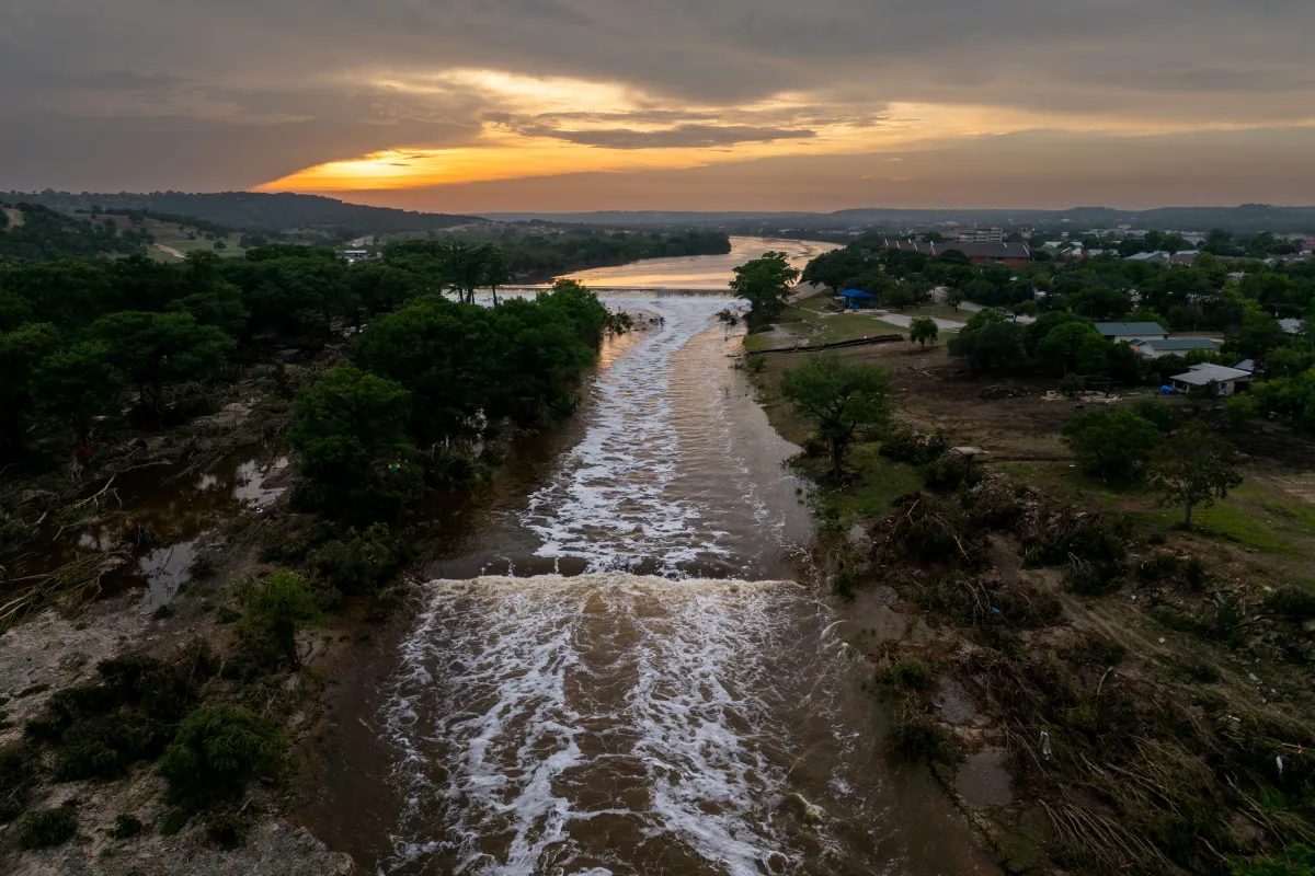
In a dramatic turn of events on Thursday, the small town of Menard, Texas found itself in the grips of a life-threatening flash flood emergency. The National Weather Service (NWS) issued their most severe flooding alert as rainfall totals reached an astonishing 9.2 inches in a single day – more than four times the typical rainfall for the entire month of November. The sudden deluge forced the evacuation of an RV park and prompted urgent warnings for all 1,300 residents to seek higher ground immediately. This rare emergency declaration reflects the serious nature of this weather event, which meteorologists had been monitoring with increasing concern throughout the week. The situation became particularly dire around 1:30 p.m. local time when heavier-than-anticipated rainfall began overwhelming the area, transforming typically tranquil streams and low-water crossings into dangerous torrents within minutes.
What makes this flooding event particularly concerning is its unusual timing and intensity for the region. November in this part of Texas typically sees modest rainfall, with most areas expecting only about an inch of precipitation throughout the month. The NWS had originally forecast up to 6 inches of rain in some locations, which was already considered alarming – but the actual downpour in Menard significantly exceeded even those upper-end predictions. This extraordinary volume of water falling in such a short timeframe overwhelmed natural drainage systems and infrastructure designed for more typical weather patterns. Roads quickly became impassable, including the critical intersection of U.S. 83 and Highway 29, cutting off potential evacuation routes and hampering emergency response efforts. The urgency in the official warnings reflected meteorologists’ understanding that conditions were deteriorating rapidly into a life-threatening situation.
The language used by the National Weather Service underscored the severity of the emergency: “This is a FLASH FLOOD EMERGENCY for Menard. This is a PARTICULARLY DANGEROUS SITUATION. SEEK HIGHER GROUND NOW!” Such flash flood emergencies are reserved for only the most catastrophic flooding events where imminent danger to human life exists. The NWS emphasized that residents should not attempt to travel unless absolutely necessary to escape flooding areas, recognizing that the landscape around Menard – with its numerous low water crossings and arroyos – becomes especially hazardous during heavy rain events. Emergency services mobilized quickly, prioritizing the most vulnerable areas including the evacuated RV park, where visitors might have been less familiar with local flood patterns and escape routes. For many residents, the warnings triggered memories of devastating floods that struck the Texas Hill Country just months earlier in July, when more than 130 lives were lost.
This severe weather system extended far beyond Menard, affecting millions of Texans across a substantial portion of the state. Flash flood warnings and watches blanketed regions including major population centers like Austin and Waco, as well as smaller communities like Del Rio. Meteorologists at various NWS offices across Texas worked continuously to monitor rainfall totals, stream gauges, and radar data, updating their forecasts and issuing increasingly urgent alerts as conditions deteriorated. The San Angelo office, responsible for the Menard area, repeatedly emphasized the deadly nature of flood waters, particularly for those in vehicles. Their warning – “Turn around, don’t drown when encountering flooded roads” – highlights a critical safety message, as most flood-related deaths occur when people attempt to drive through water-covered roadways, often underestimating both the depth of the water and its powerful current.
The geography of the Texas Hill Country exacerbates flooding dangers, with its varied terrain creating natural funnels that can rapidly concentrate rainfall into devastating flash floods. The region’s typically arid climate means the ground often cannot efficiently absorb sudden heavy rainfall, leading to rapid runoff into creeks and rivers that can rise feet within minutes. In Menard, where the San Saba River runs through the heart of town, residents are generally familiar with flood risks, but the sheer volume and speed of Thursday’s rainfall caught many by surprise. Local emergency management officials faced complex challenges – evacuating vulnerable areas while simultaneously ensuring that evacuation routes remained passable, managing communication systems that might be compromised by the weather, and preparing for potential rescue operations in extremely hazardous conditions. For many families, difficult decisions had to be made quickly about whether to shelter in place on higher floors or risk traveling through flooded areas to reach designated safe zones.
As Thursday evening approached, meteorologists predicted that the worst of the rainfall would taper off overnight, with most flood watches set to expire. However, the danger would not immediately disappear with the rain. Runoff continues to flow downstream for hours or even days after precipitation ends, and saturated ground can collapse, causing additional hazards. Emergency services prepared to transition from immediate life-saving responses to damage assessment and recovery operations once conditions allowed. For Menard and surrounding communities, the road to recovery would depend largely on the extent of infrastructure damage, particularly to roads, bridges, water systems, and electrical networks. While the immediate emergency may be short-lived, the impacts of such severe flooding often linger for weeks or months, especially for those without flood insurance or the resources to quickly rebuild. This event serves as a powerful reminder of nature’s force and the critical importance of heeding emergency warnings, maintaining awareness during severe weather, and understanding local flood risks – lessons that resonate far beyond the boundaries of this small Texas town.


