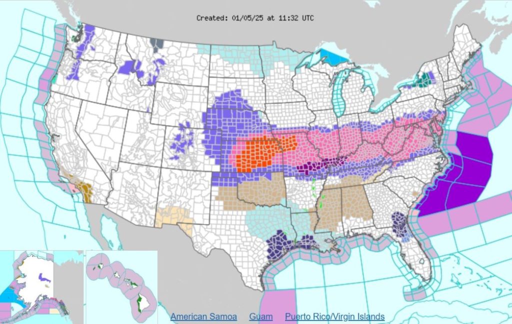
A powerful polar vortex is descending upon the United States, bringing with it a swathe of winter storm warnings and weather advisories across 15 states. The National Weather Service (NWS) has issued alerts for heavy snowfall, freezing rain, and hazardous travel conditions, impacting millions from the Midwest to the Mid-Atlantic and even reaching into Alaska. The warnings highlight the potential for significant disruptions to daily life, urging residents to prepare for challenging commutes, potential power outages, and the need to limit non-essential travel.
The NWS has deployed a color-coded map to visually represent the severity of the impending storm. Pink designates areas under a winter storm warning, indicating expectations of heavy snow accumulation – at least 6 inches within 12 hours or 8 inches within 24 hours – or significant sleet accumulation of at least half an inch. Orange signifies a blizzard warning, where conditions are expected to deteriorate further with high winds and reduced visibility creating life-threatening travel conditions. The widespread nature of the pink and orange zones on the map underscores the breadth and intensity of this winter weather event.
Across the affected states, specific forecasts vary in terms of precipitation type and accumulation. Kansas faces a multi-faceted threat, with some areas bracing for near-blizzard conditions due to heavy snow and gusty winds, while others anticipate a mix of snow, sleet, and ice. Missouri, Illinois, and Iowa anticipate heavy snow, sleet, and freezing rain, with the potential for significant ice accumulation leading to power outages and treacherous road conditions. Indiana, Nebraska, Kentucky, and Ohio are also expecting a mix of wintry precipitation, with varying snowfall totals and the possibility of ice accumulation.
The storm’s reach extends further east, impacting Pennsylvania, Virginia, West Virginia, Maryland, Washington D.C., Delaware, and New Jersey. These states are primarily facing heavy snowfall, with accumulations ranging from several inches to over a foot in higher elevations. The combination of heavy snow and potential ice accumulation creates a significant risk for hazardous travel and power outages, particularly during the Monday morning and evening commutes. Even the nation’s capital is preparing for significant snowfall, urging residents to take precautions and limit travel.
The northern Panhandle of Alaska is also experiencing the brunt of this winter storm, with Skagway and Haines anticipating heavy snowfall and strong winds. Yakutat, after a brief respite, is expected to see further snowfall potentially transitioning to rain at lower elevations as a warm front moves through. This complex interplay of precipitation types highlights the dynamic nature of this widespread weather system.
The NWS emphasizes the importance of safety and preparedness in the face of this significant winter storm. Residents in affected areas are urged to stay informed about weather updates, limit travel, and prepare for potential power outages. Essential emergency supplies, including flashlights, food, and water, should be readily available. Motorists are advised to exercise extreme caution due to the potential for rapidly changing visibility, blizzard-like conditions, and icy roads. Staying off the roads entirely is the safest option whenever possible. This widespread winter storm underscores the importance of heeding weather warnings and taking appropriate precautions to ensure personal safety.


