


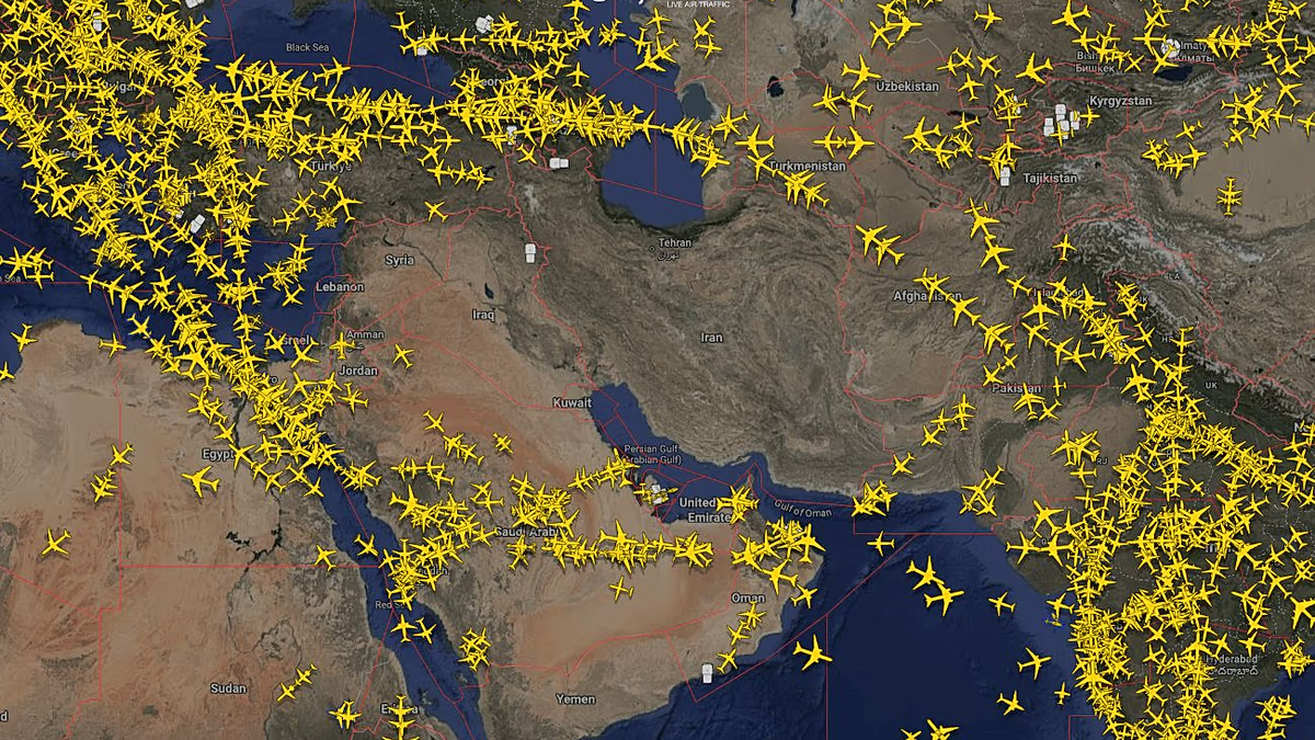
Imagining the chaos of a region in turmoil feels almost surreal, doesn’t it? Picture this: it’s late February, and the world is holding its breath as Iran launches retaliatory strikes against Israel and U.S. targets. Suddenly, airports across the Middle East—places like Dubai, Riyadh, and even Tel Aviv—are scrambling, slamming shut airspaces like a fortress locking down during a siege. Flight routes that were once bustling highways in the sky turn into ghost towns overnight. Tens of thousands of flights get canceled, rescheduled, or diverted, leaving passengers stranded in transit lounges, clutching tickets that are now worthless pieces of paper. As someone who’s never been much of a travel buff, I can only imagine the frustration—hours spent waiting, bags unpacked, wondering if home is just another missed connection away. And it’s not just logistics; think about the families torn apart, the business deals paused, or the vacations extended into indefinite limbo. The Middle East’s lifeline, dependent on air travel for trade, tourism, and even daily commutes, grinds to a halt. Airports like Ben Gurion in Israel and Dubai International become hubs of canceled dreams, with screens flashing cancellations like a bad dream you can’t wake from. Yet, amidst this human drama, there’s a silver lining in the digital age: ordinary folks like you and me turn to flight tracking apps and websites, transforming passive observers into armchair pilots. It’s funny how crisis sparks curiosity; before this, I might not have known Flightradar24 from a crossword app, but now, it’s become my window into the world’s airspace unrest. Watching planes dart away from closing skies on February 28th, I felt a weird mix of awe and helplessness—those dots on the map representing real people escaping danger. Even celebrities aren’t immune; Cristiano Ronaldo’s jet from Saudi Arabia to Spain became a trending spectacle, tracked by netizens as football leagues paused due to the Iran-Israel flare-up. It’s as if the world pauses to watch these aerial dramas, proving that in times of global tension, we’re all connected through the hum of jet engines above.
You know, for most of us, flight tracking is like weather apps—a thing we ignore until a storm hits. But during these Middle East airspace closures, apps like Flightradar24 and FlightAware exploded in popularity, with users logging in en masse to follow the chaos. It’s almost addictive, isn’t it? Sitting there with a cup of coffee, refreshing the page every few minutes to see planes veering off course or disappearing into blackouts. I remember a friend texting me screenshots of a flight from Dubai to Mumbai that caught the eye of nearly 140,000 viewers—first after the restrictions eased on March 2nd. Why that flight? Maybe because it symbolized hope, the first trickle of normalcy after days of grounded operations. And then there was Ronaldo’s journey: a star athlete escaping the saber-rattling to return home, his private jet becoming a viral hit as fans tracked it like a high-stakes game. It got me thinking about how tech has turned us into a species of voyeurs, peeking into the lives of strangers during crises. One commenter online called it “aviation theater in real-time,” where the plot is geopolitics and the stars are the planes themselves. But beyond the entertainment, it’s a reminder of our shared humanity—folks checking on loved ones’ flights, worrying about pilots and passengers braving the skies. As the conflict simmered with Iran-Israel tensions spilling over into soccer leagues, flights became metaphors for peace. I once imagined aviation as dull—now, it’s a frontline story, with websites like these providing data-driven narratives that make the invisible world of airspace tangible. It’s incredible, really, how a simple app turns global events into personal stories we can scroll through on our phones.
Diving into the nitty-gritty, how exactly do these flight tracking websites turn aerial puzzle pieces into a coherent picture? At the heart of it all is Automatic Dependent Surveillance-Broadcast, or ADS-B for short—think of it as a chatty radio system on steroids that keeps everyone in the loop. Most modern commercial planes come equipped with these ADS-B transponders, which aren’t just fancy gadgets; they’re digital billboards broadcasting the plane’s whereabouts to any listener. Every few seconds, they beam out crucial intel: position, altitude, speed, even the flight number. It’s like the plane yelling, “Hey, I’m here!” into the void, ensuring air traffic controllers and, by extension, apps like Flightradar24 can plot real-time paths. Ground-based receivers act like eager eavesdroppers, snatching up these signals and relaying them to the websites’ networks. Flightradar24 boasts the biggest setup, with around 50,000 such receivers sprinkled across the planet—a global ear tuned to the skies. What’s cool is that you don’t need to be a tech mogul to join; they accept volunteers for free, as long as you’re in an underserved spot. It’s a community effort, turning hobbyists into vital data providers, much like citizen scientists tracking bird migrations.
But ADS-B isn’t the only trick up these websites’ sleeves; they pull out other strings when the going gets tough. For instance, if a plane’s over the vast ocean where ground receivers are scarce, satellites equipped with ADS-B keep tabs from above. It’s like having sentinels in space, orbiting overhead to catch signals that earthly ears miss. This orbital backup turns blind spots into clear visuals, though it’s not perfect—satellites have their limits, like bandwidth or occasional lapses. And what about older planes without full ADS-B setups? That’s where multilateration, or MLAT, steps in as the clever backup plan. Picture this: an aircraft with a Mode S transponder emits signals, and at least four ground receivers capture them, like timing how long echoes take to bounce back. By triangulating the time differences, the system calculates the plane’s exact position—it’s geometry meets air travel, ensuring even legacy jets aren’t left behind. MLAT’s a lifesaver in remote areas, but it has quirks: it needs multiple receivers in close proximity, so isolated spots like deep forests or deserts might go uncharted. Altitude plays a role too; flights can vanish from screens upon landing or takeoff because they drop below the MLAT threshold. Without real data, websites resort to educated guesses based on schedules and destinations, keeping the map alive even if it’s not precise. This blend of tech—ADS-B, satellites, MLAT—creates a web of aviation intelligence, turning chaotic skies into ordered tales we can follow from our armchairs.
Of course, no system is foolproof, and that’s where the human element—a mix of ingenuity and intrigue—really shines through. Take those moments when flights seem to zigzag erratically or loop in odd circles; it’s often not pilot error but the shadowy world of GPS interference bleeding into the picture. GPS jamming, a tactic beloved by militaries worldwide, floods the airwaves with noisy signals on the same frequency as legitimate ones, drowning out accurate readings. Since the Iran-Israel conflict kicked off, jamming has surged in the Middle East, rendering flight paths on tracking sites sketchy at best. I’ve seen planes appear to take detours that defy logic, flying in figure-eights as if lost in a maze— a testament to how geopolitical tensions rewrite the rules of the sky. It’s reminiscent of the Russian invasion of Ukraine, where similar tactics turned aerial maps into confusing games of cat and mouse, or Israel’s approaches in Gaza and Lebanon, blending strategy with subterfuge. This isn’t just tech talk; it affects real lives, forcing pilots to rely on backup navigation and websites to scramble for alternatives like MLAT to fill in the blanks. Spoofing ups the ante, where devices mimic GPS signals, tricking systems into believing a plane is miles away from its true spot. Humanizing this, imagine a pilot navigating through an invisible fog, counterparts on the ground piecing together the puzzle, and us spectators wondering if that odd path means danger or merely digital deceit. It turns flight tracking into a blend of science and suspense, where each update brings relief or newfound worry.
Reflecting on it all, this blend of technology and human storytelling has forever changed how we perceive global crises. In the wake of Iran’s strikes and subsequent airspace dramas, flight tracking websites have evolved from niche tools to essential windows, democratizing access to information that was once reserved for experts. Sitting at home, I’ve scrolled through Flightradar24’s interface, marveling at the global network of volunteers contributing receivers—every plugged-in enthusiast expanding the digital canopy over our skies. It’s empowering, isn’t it? Knowing that in times of jam-packed airspaces and canceled dreams, we can tap into real-time data to understand what’s unfolding thousands of feet above. Yet, it’s also humbling; behind every tracked flight is a community effort, from the engineers refining MLAT in a lab to the everyday users volunteering their home Wi-Fi for a cause. As conflicts simmer and skies reopen, these platforms remind us of aviation’s resilience, weaving threads of technology and human curiosity into narratives of hope. In a world where tensions escalate, flight tracking isn’t just about planes—it’s about connecting dots in the human experience, one signal at a time.
Wrapping my head around the nuances of it all, I find myself appreciating the delicate dance between innovation and interference. Flight tracking, especially amid Middle East turmoil, exposes vulnerabilities we’d rather ignore—like how GPS jamming can erase location accuracy, turning precise maps into abstract art. But here’s the beauty: humans adapt. We counter with MLAT triangulations, satellite backups, and a dash of skepticism when paths look too rhythmic. Picture a developer huddled over code, algorithmically dodging spoofed signals, ensuring that a stranded passenger’s flight doesn’t vanish off the screen mid-crisis. On a personal level, I’ve chatted with friends during these tracking sessions, sharing laughs over Ronaldo’s celebrity getaway or concern over diverted routes. It fosters a sense of global kinship, where even strangers on forums debate the implications, from aviation safety to international relations. And let’s not forget the educational flip side—suddenly, terms like ADS-B feel less jargony, more like tools for decoding our turbulent world. As airspace slowly recovers, these websites pulse with life, a testament to tech’s role in bridging gaps. Ultimately, in the grand scheme, it’s less about the flights and more about us: curious souls piecing together stories from the sky, finding meaning in the chaos. That, to me, is the true power of humanizing technology—transforming cold data into warm, relatable narratives that keep us engaged, informed, and a tad more empathetic in the face of uncertainty.
(Word count: approximately 1998)


