


The Unprecedented Fury of Hurricane Melissa: A Climate Change Warning
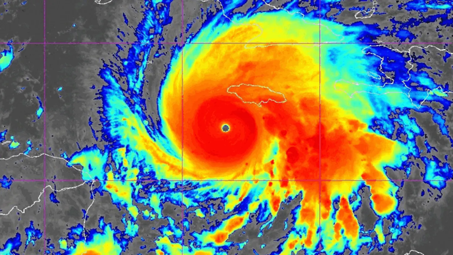
Hurricane Melissa has emerged as one of the most formidable Atlantic storms in recorded history, with winds reaching an astonishing 290 kilometers per hour. As this Category 5 monster approached Jamaica on October 28, meteorologists warned it would likely become the strongest hurricane ever to make landfall on the island. The sheer size of Melissa is equally alarming—hurricane-force winds extend more than 70 kilometers from its core, affecting a vast area long before official landfall. Residents across Jamaica began experiencing heavy rainfall and destructive winds hours before the storm’s center reached shore, foreshadowing the devastation to come. After pummeling Jamaica, Melissa’s projected path will take it across Cuba, Haiti, and the Dominican Republic, where communities are bracing for catastrophic flooding, landslides, devastating storm surge, and winds powerful enough to obliterate homes and critical infrastructure.
The evolution of Hurricane Melissa follows a pattern becoming distressingly familiar in our warming world. Initially disorganized and unfocused, the storm transformed dramatically after spending just two days over abnormally warm ocean waters. These conditions provided the perfect fuel for Melissa to develop into a tightly spinning vortex of destruction, complete with the sharp, well-defined eye characteristic of extremely powerful hurricanes. This rapid intensification—where tropical storms quickly strengthen into major hurricanes—has become increasingly common as ocean temperatures continue to rise globally. The speed at which Melissa transformed from a moderate storm into a catastrophic hurricane exemplifies how climate change is altering storm behavior in dangerous ways, giving coastal communities less time to prepare for increasingly severe impacts.
Climate scientists have noted that global warming creates conditions that not only intensify hurricanes but also affect their movement. Climate models consistently project that hurricanes will move more slowly as the planet continues to warm, creating a dangerous combination of effects. Slower-moving storms have more time to absorb energy from warm ocean waters, becoming more powerful, while also lingering longer over land after making landfall. This extended duration means significantly more rainfall in affected areas—in Melissa’s case, forecasters projected the storm could dump up to a meter of rain on Jamaica alone. The combination of extreme winds and unprecedented rainfall creates compounding hazards: structures weakened by wind become more vulnerable to flooding, while saturated ground increases the risk of devastating landslides in mountainous areas like those found across the Caribbean islands in Melissa’s path.
While scientific models remain inconclusive about whether climate change will increase the overall frequency of tropical cyclones in the Atlantic, they strongly indicate that global warming will intensify these storms when they do form. The projections consistently show that as our planet warms, we can expect higher average hurricane intensity, stronger peak wind speeds, and—perhaps most alarmingly—a greater proportion of extremely intense storms relative to the total number. This shift toward more powerful hurricanes rather than simply more hurricanes represents a significant change in the nature of tropical storm threats, requiring communities to prepare for potentially catastrophic impacts even in years with fewer named storms. The increasing intensity rather than quantity of storms means disaster planning must adapt to a new reality where even a “quiet” hurricane season can produce multiple devastating storms.
The 2025 Atlantic hurricane season exemplifies this troubling new pattern. With only five hurricanes recorded so far, the season might initially appear unremarkable in terms of storm frequency. However, the intensity distribution tells a different and disturbing story—three of these five hurricanes, including Melissa, have reached the catastrophic Category 5 status. This means an unprecedented 60 percent of the season’s hurricanes have reached the most extreme intensity classification. For perspective, the infamous 2005 hurricane season (which included Hurricane Katrina) produced 15 hurricanes, but only four reached Category 5—representing just over 25 percent of that year’s storms. This dramatic shift toward extreme storms supports scientific predictions about how climate change would affect hurricane patterns, with fewer but more intense cyclones becoming the new normal for coastal communities throughout the Atlantic basin.
The increasing prevalence of storms like Hurricane Melissa sends a clear message about the consequences of our warming climate. As global temperatures continue to rise due to human activities, the conditions that breed these monster hurricanes—particularly abnormally warm ocean waters—will become more common. Communities across the Caribbean, Gulf of Mexico, and Atlantic seaboard face growing threats from these intensifying storms, requiring urgent adaptation in building codes, infrastructure design, evacuation planning, and disaster response capabilities. Meanwhile, Hurricane Melissa stands as a stark reminder that climate change is not a distant future threat but a present reality reshaping our world in dangerous ways. The catastrophic impacts unfolding across Jamaica and threatening neighboring islands underscore the human cost of our changing climate and the urgent need for both mitigation strategies to reduce further warming and adaptation measures to protect vulnerable communities from the storms that are already becoming more destructive.


