


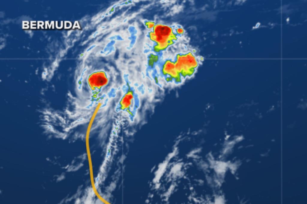
Tropical Storm Fernand Forms Near Bermuda as Atlantic Hurricane Season Continues
Amidst the peak of the Atlantic hurricane season, a new tropical system has emerged in the waters southeast of Bermuda. Designated as Tropical Storm Fernand on Saturday, this weather system is currently positioned approximately 400 miles south-southeast of the island territory. According to data gathered by an Air Force Reserve reconnaissance mission and satellite imagery, Fernand has developed sustained winds around 40 mph with occasional higher gusts. Meteorologists at the National Hurricane Center (NHC) are closely tracking its northward trajectory and anticipate steady strengthening over the coming days. While Fernand is expected to pass east of Bermuda rather than making a direct hit, the island will not escape its influence entirely. Residents and visitors should prepare for dangerous surf conditions and potential gale-force winds as the storm makes its closest approach during the early part of the workweek. Though current projections indicate the system will remain well away from the United States mainland, authorities are cautioning Bermudians that even a slight westward shift in Fernand’s path could significantly increase local impacts.
The life cycle of Tropical Storm Fernand appears to be following a typical pattern for late-season Atlantic systems. The NHC predicts that after potentially reaching hurricane strength in the warm waters near Bermuda, Fernand will begin to weaken by Monday as it encounters less favorable environmental conditions. “After Monday, Fernand should weaken due to the influences of cooler waters and increasing shear, and the storm will likely become post-tropical in 3-4 days,” explained forecasters from the NHC. Despite this eventual weakening, the storm’s effects will continue to be felt along coastlines far from its center. The combination of large ocean swells generated by both Fernand and the remnants of Hurricane Erin is expected to create dangerous rip current conditions along the U.S. East Coast that may persist well into the coming week. This extended threat highlights how tropical systems can impact coastal areas even without making landfall, creating hazards for swimmers and boaters hundreds of miles from the actual storm.
For mainland Americans, particularly those in the eastern half of the country, there is good news regarding tropical threats. An extensive weather trough spanning the eastern United States is currently acting as a natural barrier against approaching hurricanes, likely protecting the country from direct tropical impacts through the remainder of September. This atmospheric configuration not only helps deflect storms but has also delivered an early taste of autumn to more than 100 million people living east of the Rocky Mountains. Many regions are experiencing remarkably cool conditions, with temperatures ranging from 10 to 30 degrees below seasonal averages. This refreshing break from summer heat comes as a welcome side effect of the same weather pattern providing protection from tropical systems, offering a silver lining to what has been an active hurricane season thus far.
While Fernand commands immediate attention, meteorologists are already monitoring another potential system in the Atlantic basin. Designated as Invest 99L, this tropical disturbance is currently positioned less than 1,000 miles east of the Caribbean islands. However, development appears less certain with this system than with Fernand. Forecasters note that any strengthening would likely occur slowly, if at all, due to challenging environmental conditions including unfavorable upper-level winds and dry air intrusions. These factors typically inhibit tropical cyclone formation by disrupting the organization of thunderstorm activity and preventing the establishment of a well-defined circulation center. Nevertheless, some computer forecast models suggest 99L could potentially develop later in the western Caribbean or southern Gulf of Mexico, though this possibility lies beyond the current seven-day forecast window, making it a situation worth monitoring but not an immediate concern.
The emergence of Tropical Storm Fernand marks the sixth named system of the 2023 Atlantic hurricane season, with the next storm to be designated as Gabrielle. This pace of storm development aligns with predictions for an above-average hurricane season, which typically reaches its most active phase during September. The combination of warm ocean temperatures, favorable atmospheric conditions, and seasonal patterns all contribute to this annual peak in tropical cyclone formation. Historical data shows that mid-September typically represents the absolute peak of hurricane season activity, with the greatest number of concurrent systems often observed during this period. The Atlantic hurricane season officially continues through November 30, though storm formation becomes increasingly less likely as ocean temperatures cool and wind patterns become less conducive to tropical development during the latter part of autumn.
For coastal residents from the Caribbean to the Eastern Seaboard, the development of Tropical Storm Fernand serves as a timely reminder of the importance of hurricane preparedness. While current forecasts suggest minimal direct impacts to populated areas from this particular system, the unpredictable nature of tropical weather necessitates ongoing vigilance. Emergency management officials consistently emphasize that preparation should occur well before a storm threatens, including having evacuation plans in place, maintaining emergency supply kits, and staying informed through reliable weather information sources. Even storms that remain offshore, like Fernand is predicted to do, can create dangerous conditions for mariners and coastal communities through high surf, rip currents, beach erosion, and occasional outer rain bands. As the Atlantic hurricane season continues through its most active phase, both meteorologists and emergency managers will maintain close observation of evolving systems, working to provide the public with accurate information and sufficient warning time to implement safety measures when necessary.


