


")


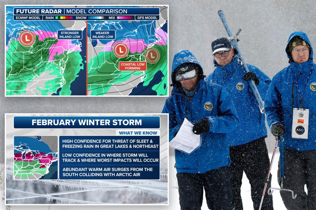
A significant winter storm is poised to impact portions of the Midwest and Northeast on Wednesday and Thursday, bringing with it the threat of sleet and freezing rain. While the precise locations that will bear the brunt of the storm’s icy onslaught remain uncertain, meteorologists are closely monitoring two potential scenarios, each with distinct implications for the affected regions. The primary concern revolves around the formation and trajectory of a low-pressure system over the Plains and its interaction with a potent jet stream carrying warm, moist air.
The first scenario envisions a strong low-pressure system developing over the Plains and subsequently moving eastward, colliding with a robust jet stream. This interaction would likely result in a significant swathe of freezing rain across the Midwest and Northeast, particularly along the Interstate 90 corridor. The influx of warm, moist air aloft, combined with subfreezing temperatures at the surface, creates the ideal conditions for freezing rain. This type of precipitation falls as rain but freezes upon contact with surfaces that are below freezing, leading to a treacherous buildup of ice.
Alternatively, the second scenario posits a weaker low-pressure system forming over the Plains, while a stronger coastal storm develops along the East Coast, eventually dominating the weather pattern. This scenario would shift the focus of the ice threat eastward, concentrating it over New England, while the Midwest would experience less freezing rain. The development of a strong coastal storm would draw the warm, moist air towards the Northeast, enhancing the potential for freezing rain in that region.
Regardless of which scenario unfolds, cities spanning a wide swathe of the country, from Des Moines, Iowa, to Syracuse, New York, are advised to prepare for the potential of significant ice accumulation. The primary concern revolves around travel conditions, as even a thin layer of ice can make roads, bridges, and overpasses extremely hazardous. Drivers should exercise extreme caution or avoid travel altogether if possible. Pedestrians should also be wary of slippery sidewalks and other surfaces.
The insidious nature of freezing rain lies in its gradual accumulation. Unlike snow, which is readily visible, ice can build up almost imperceptibly, coating surfaces with a thin, transparent layer that poses a serious threat to both motorists and pedestrians. Bridges and overpasses are particularly vulnerable to icing due to their exposure to colder air from above and below. Even when road surfaces appear clear, these elevated structures can quickly become treacherous ice traps.
The timing of the freezing rain is also a critical factor. The current forecast suggests that the most significant icing event is likely to occur during the early to mid-day hours of Thursday. This timeframe coincides with the morning and afternoon commutes, further exacerbating the potential for travel disruptions and accidents. Authorities may be forced to close roads and bridges, and significant delays are anticipated.
The impending winter storm is not solely characterized by the threat of freezing rain. Subfreezing temperatures are also expected to grip the northern half of the United States in the wake of the storm. This cold air intrusion will further complicate the situation by prolonging the duration of icy conditions and hindering efforts to clear roads and restore normalcy. The combination of freezing rain and subfreezing temperatures creates a particularly challenging scenario for emergency responders and utility crews.
As the storm approaches, meteorologists are diligently analyzing forecast models to refine their predictions and provide more precise information regarding the areas most likely to experience the worst conditions and the anticipated ice accumulation. These models incorporate a vast amount of data, including atmospheric conditions, temperature profiles, and precipitation patterns, to generate detailed simulations of the storm’s evolution. The accuracy of these forecasts improves as the storm draws closer and more real-time data becomes available.
The public is strongly urged to stay informed and monitor weather reports closely for updates and potential warnings. Preparedness is key to mitigating the impact of winter storms. Ensure that you have a well-stocked emergency kit, including food, water, blankets, and flashlights, in case of power outages. If travel is unavoidable, inform someone of your route and expected arrival time. Stay tuned to local news and weather broadcasts for the latest information on road conditions and closures.


