


A significant winter storm is brewing, poised to unleash a potentially dangerous ice threat across a vast swathe of the United States, spanning from the Midwest to the Northeast. While the precise trajectory of the storm remains uncertain, meteorologists warn that sleet and freezing rain could severely disrupt travel and daily life for millions. This impending storm is connected to the recent atmospheric river events that have relentlessly pummeled the West Coast with copious rain and heavy mountain snow. One of these systems will transition eastward and contribute to the development of this hazardous winter weather event.
The storm’s genesis involves a low-pressure system forming over the Plains by Tuesday. Initially, this system will lack the necessary moisture to intensify significantly. However, as it progresses eastward, a powerful southerly jet stream will engage, drawing warm, moisture-laden air across the eastern half of the U.S. This dynamic will establish a distinct warm front, separating the frigid air to the north from the record-breaking warmth engulfing the South. The crux of the problem lies in the interaction of this warm, moist air with a shallow layer of subfreezing air near the ground. This specific atmospheric setup is highly conducive to the formation of freezing rain, creating treacherous conditions on roads and potentially causing power outages due to ice accumulation on power lines and trees.
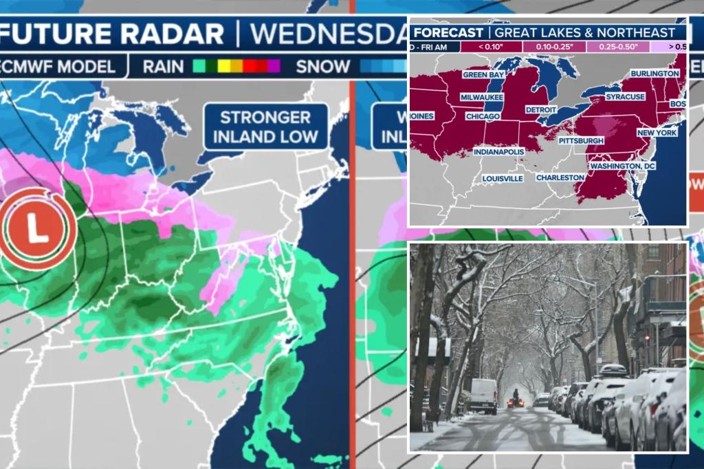
Two primary scenarios are currently being considered by forecasters. The first involves the strengthening of the low-pressure system over the Plains, allowing it to remain the dominant weather feature. This scenario would see a stronger jet stream pulling in abundant warm, moist air, resulting in more extensive freezing rain along the Interstate 90 corridor, stretching from the Midwest to the Northeast. Cities like Des Moines, Iowa; Chicago, Illinois; Syracuse, New York; and Burlington, Vermont could experience significant ice accretion, leading to hazardous travel and potential power outages. The widespread nature of the potential icing zone is particularly concerning, as it poses a greater risk to a larger population compared to a narrow band of freezing rain.
The second scenario involves a weaker low-pressure system developing over the Plains, with a new coastal low forming along the East Coast and eventually becoming the dominant system. This scenario would result in a weaker low-level jet stream, leading to less widespread freezing rain. However, certain areas, such as the Ohio Valley and Pennsylvania, could still face a substantial ice threat. In this scenario, Des Moines and Chicago might be spared the worst of the icing, while Syracuse and Burlington could transition to an all-snow event. While less geographically extensive, the icing could still pose significant challenges in the affected regions.
The impact on Interstate 90, a major transportation artery, is a significant concern. In the first scenario, a substantial stretch of I-90 could experience significant ice accumulation, severely impacting travel and commerce across the region. The stronger jet stream would also push the freezing rain further into New England. However, heavy rain in some areas could mitigate the ice buildup by washing it away before it has a chance to freeze. If the second scenario unfolds, the worst of the icing might be avoided in the Midwest, with a shift towards a snowier outcome for New England. However, icing along I-90 would still remain a likely possibility.
Beyond the immediate travel disruptions, the potential for power outages is a serious concern. Ice accumulation on power lines and trees can cause them to snap, leading to widespread power outages, especially if the first scenario unfolds with its potential for heavier ice accretion. Residents in the potentially affected areas are advised to prepare for power outages by gathering essential supplies like flashlights, batteries, and non-perishable food. Staying informed about the evolving forecast is crucial.
The evolving nature of this weather system underscores the importance of staying updated on the latest forecasts. The projected path and intensity of the storm could change in the coming days, making it crucial to monitor weather reports and heed any advisories issued by local authorities. Downloading a reliable weather app and enabling notifications can provide timely updates and help individuals prepare for potential impacts. Staying informed and taking appropriate precautions will be essential for mitigating the risks associated with this potentially hazardous winter storm. As the storm develops, forecasters will continue to refine their predictions, providing a clearer picture of the expected impacts.


