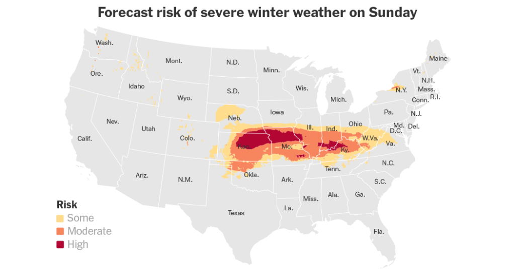
A powerful winter storm swept across the United States, impacting a vast swathe of land stretching over 1,500 miles from eastern Colorado to the Mid-Atlantic states. The storm brought a treacherous mix of sleet, snow, and freezing rain, leading to widespread disruptions and hazardous travel conditions. Millions were placed under winter weather advisories, watches, and warnings, bracing for the storm’s impact. The storm’s effects were felt early on, with power outages reported in several states, including Kansas, where thousands were left without electricity. The combination of heavy snow, freezing rain, and strong winds created perilous conditions on roads and highways, leading to numerous accidents and closures. Several states, anticipating the severity of the storm, declared states of emergency or preparedness to mobilize resources and facilitate effective response efforts.
The storm’s trajectory carried it across the central Plains and the mid-Mississippi Valley, bringing heavy snowfall to areas from northeast Missouri to the central Appalachian Mountains. Some regions were predicted to receive their heaviest snowfall in a decade, with accumulations exceeding 15 inches in certain areas. Blizzard warnings were issued, cautioning residents of strong winds and severely reduced visibility. The combination of heavy snow and high winds created blizzard or near-blizzard conditions, making travel extremely dangerous and potentially stranding drivers. State highway patrols and transportation departments worked tirelessly to clear roads and respond to accidents, but even their efforts were hampered by the treacherous conditions.
The storm’s icy grip extended beyond snowfall. A significant swathe of the affected area, from central Kansas to the central Appalachians, experienced freezing rain, coating surfaces with a layer of ice. This posed a significant threat to power lines, trees, and transportation infrastructure. The accumulated ice added to the dangers on roadways, increasing the risk of accidents and making travel nearly impossible in some areas. Residents were urged to stay home and avoid unnecessary travel to minimize the risk of accidents and allow emergency services to operate effectively.
As the storm moved eastward, it transitioned from snow to a mix of rain and thunderstorms in parts of the lower Mississippi Valley. This posed a different set of threats, including damaging wind gusts, hail, and the possibility of tornadoes. The Storm Prediction Center issued severe thunderstorm warnings for parts of Arkansas, Louisiana, and Mississippi, highlighting the potential for significant weather-related impacts. The storm’s complex nature underscored the wide range of hazards it presented across the affected regions.
The Mid-Atlantic region, including major cities like Baltimore and Washington D.C., braced for significant snowfall as the storm continued its eastward march. Forecasters predicted several inches of snow, with the potential for higher accumulations depending on the storm’s precise track. The heavy snow threatened to disrupt travel and daily life in the region, prompting preparations for snow removal and emergency response. The timing of the storm coincided with the funeral procession for former President Jimmy Carter, adding another layer of complexity to the situation.
In the aftermath of the storm, the affected areas faced the challenge of cleanup and recovery. The combination of heavy snow, ice, and strong winds left behind a trail of downed trees, power outages, and impassable roads. The frigid temperatures that followed the storm further complicated recovery efforts. Temperatures plummeted well below seasonal averages, making it difficult to clear roads and restore power. The widespread impact of the storm highlighted the importance of preparedness and the challenges of dealing with severe winter weather events.


