


New Winter Storm Bringing Arctic Blast to Usher in the New Year
In the wake of a powerful winter storm that recently hit the Northeast with snow and travel disruptions during one of the year’s busiest travel periods, residents along the East Coast now face another weather system threatening to bring 2024 in with a frigid welcome. This new fast-moving system is set to deliver a mix of precipitation coupled with an Arctic air mass that will significantly drop temperatures below seasonal averages. The situation has already proven serious enough that both New York and New Jersey declared States of Emergency as thousands of flights faced delays and cancellations on Friday, leaving holiday travelers stranded and frustrated during what should have been joyful post-Christmas journeys home.
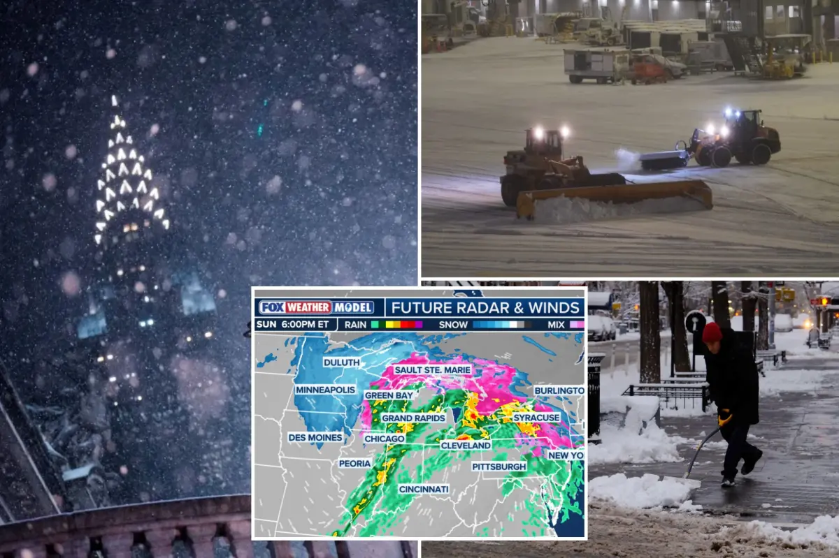
The approaching weather pattern features a lengthy trailing cold front that meteorologists are monitoring closely, as it presents multiple hazards across different regions. Beginning Sunday, a low-pressure system will move through the Upper Midwest, bringing a dangerous combination of rain, snow, and strong winds. As this system pushes eastward, it will draw colder air into the region, transforming rain into snow across areas from Minneapolis into Michigan. While most locations can expect moderate snowfall between 5 to 8 inches, the real concern lies around the northern Great Lakes, where shifting winds and colder air are expected to trigger lake-effect snow. These bands of intense precipitation could dump as much as 18 inches in localized areas, creating hazardous travel conditions and potentially isolating some communities as the calendar turns to January.
The threat doesn’t end with snow, however. The southern portions of the Great Lakes region face a different but equally concerning risk: flash flooding. With rainfall totals expected to reach 1 to 2 inches across a broad area, normally this wouldn’t cause significant issues. However, the combination of existing snowpack and unseasonably warm temperatures ahead of the front creates perfect conditions for rapid snowmelt. Cities stretching from Chicago to Cleveland and Buffalo may experience flooding as water has nowhere to go when rain falls on frozen or saturated ground. Meanwhile, as the front pushes into the Tennessee Valley, it brings yet another threat in the form of potentially severe thunderstorms. Areas from northern Indiana south into Missouri, including major population centers like Indianapolis, St. Louis, Louisville, and Nashville, are under a Level 1 of 5 severe storm threat, with damaging winds being the primary concern, though isolated tornadoes cannot be ruled out due to the wind shear present.
By Sunday evening, the storm system will reach the Northeast, where rain will become the predominant precipitation type, washing away much of the snow that fell during the previous storm. However, the transition won’t be smooth for everyone. In New England, especially in higher elevations, cold air trapped near the surface will create dangerous icing conditions as rain falls onto subfreezing surfaces. Winter Weather Alerts have been issued across most of New England, warning of ice accumulations up to 0.10 inches – enough to create treacherous driving and walking conditions and potentially bring down tree limbs and power lines. The major population centers along the I-95 corridor will likely escape the worst of these icy conditions, as temperatures are expected to remain warm enough for precipitation to fall entirely as rain, giving residents in Boston, New York, Philadelphia, and Washington D.C. a temporary reprieve from winter’s full force.
The storm’s impact won’t end with its passage, however. A quick burst of high, gusty winds will sweep from the Midwest to the Northeast in its wake, potentially causing power outages just as temperatures begin to plummet. The dramatic shift will occur as winds pivot from the south to the northwest, drawing in significantly colder air behind the front. This cold air rushing across the relatively warm waters of Lakes Erie and Ontario will trigger intense lake-effect snow bands that could persist through Tuesday. Portions of Western and Upstate New York, areas already familiar with lake-effect snow phenomena, are bracing for substantial accumulations that could exceed one foot in some locations. These snow bands, often narrow but intense, can create vastly different conditions from one neighborhood to the next, further complicating travel and recovery efforts.
As we bid farewell to 2023 and welcome 2024, this winter storm serves as a reminder of nature’s complexity and power. From snow to ice to rain to wind, this single weather system encompasses nearly all of winter’s challenges in one sweeping front. For millions of Americans, New Year’s celebrations may need to be adapted to account for these conditions, whether that means staying closer to home, preparing for potential power outages, or simply bundling up against the coming Arctic blast. As communities across the eastern half of the country face these varied threats, emergency services are preparing for increased calls and potential rescue operations. Weather forecasters continue to monitor the system closely, emphasizing that even small shifts in the storm’s track or temperature profiles could significantly alter local impacts, making it essential for residents to stay informed about rapidly changing conditions in their specific areas as we transition into the New Year.


