Severe Storm System Sweeps Through America’s Heartland
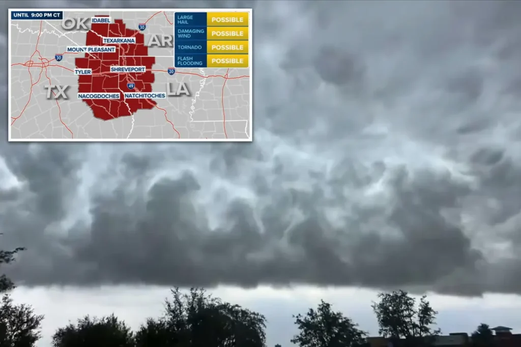
A massive storm system that originated in Texas is currently making its way through the Mississippi Valley, bringing with it a host of dangerous weather conditions that threaten over 50 million Americans. The collision of warm, humid Gulf air with a powerful cold front has created explosive weather patterns across multiple states, setting the stage for what meteorologists are calling a significant severe weather event. National Weather Service officials have issued tornado watches for parts of Oklahoma, Texas, Louisiana, and Arkansas, with severe thunderstorm watches extending eastward across the lower Mississippi Valley. This weather phenomenon represents a classic autumn pattern where temperature contrasts create ideal conditions for severe storms—a reminder that tornado season isn’t limited to spring months.
The driving force behind this meteorological drama is what Fox Weather meteorologist Nick Kosir described as a “big cold front” moving through the nation’s midsection. As the day progresses, conditions are becoming increasingly unstable, putting several regions at heightened risk. Areas in and around Little Rock and Fort Smith, Arkansas, along with communities to their south, appear to be in what Kosir called “the bullseye” for potential severe weather impacts. The system’s reach extends to major population centers including Memphis, Tennessee; Jackson, Mississippi; Shreveport, Louisiana; and Springfield, Illinois. Residents in these areas are being warned to prepare for powerful wind gusts that could reach 75 mph—strong enough to bring down trees and power lines—along with torrential rainfall and hailstones potentially measuring up to an inch and a half in diameter.
Perhaps most concerning to weather experts is the tornado threat embedded within this system. Forecasters have warned that isolated tornadoes could develop rapidly within these storm cells with little advance warning. Meteorologist Bayne Froney noted that while October tornadoes aren’t unheard of, they’re less common than during the traditional spring tornado season, making it “a good reminder to always be aware and keep your wits about you, even as we move into those cooler weather days.” This autumn severe weather pattern represents what Froney described as “our second severe season” that emerges as temperature disparities increase during the transitional fall period. The meteorologist also emphasized that flash flooding poses a significant concurrent threat, as the storms are expected to deliver intense rainfall amounts in short periods.
The scope of this weather event is reflected in the Storm Prediction Center’s risk assessments, which placed more than 13 million people under a level 2 (out of 5) risk for severe weather. This heightened alert area encompasses Arkansas, Mississippi, Louisiana, Tennessee, Missouri, and portions of Oklahoma and Texas. An additional 40 million people across the Gulf Coast, southern Plains, and Ohio Valley regions were placed under a level 1 threat designation. These tiered risk classifications help emergency management officials and residents understand the relative severity of anticipated conditions, though meteorologists stress that dangerous weather can occur even in lower-risk zones. The combination of widespread heavy rainfall and strong winds means that impacts could be felt well beyond the immediate tornado risk areas.
Weather experts tracking the storm system anticipate that isolated supercell thunderstorms—the most intense type of thunderstorm and most likely to produce tornadoes—could eventually merge into a larger, more organized line of storms as Saturday progresses. This evolution would likely shift the primary threat from isolated tornadoes toward widespread damaging winds, though brief tornado spinups would remain possible, especially as the system moves overnight toward the Gulf Coast. The timing of these storms adds an additional layer of danger, as nighttime tornadoes are particularly hazardous since they’re difficult to spot and can strike when many people are sleeping. Emergency management officials recommend that residents in the affected areas ensure they have multiple ways to receive weather warnings, particularly methods that can wake them if alerts are issued overnight.
The volatile weather system isn’t expected to dissipate quickly. Meteorologists project that the front will continue its eastward march through Sunday and into Monday, spreading thunderstorm activity across the Southeast and into the Appalachian region. This extended timeline means that millions of Americans will need to remain weather-aware throughout the weekend as the threat shifts geographically. The progression of severe weather from the Mississippi Valley into more eastern states follows a typical pattern for large-scale autumn storm systems. While the specific threats may evolve as the system moves, the potential for impactful weather continues as the cold front interacts with the warm, moist air mass ahead of it. Residents across the eastern third of the country are being advised to stay informed about changing weather conditions and heed any warnings or advisories issued by local weather offices in the coming days.


