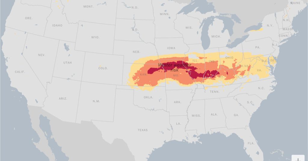
A powerful winter storm, fueled by Arctic air, is set to unleash a barrage of snow, sleet, and freezing rain across a vast swathe of the United States this weekend. The storm’s trajectory spans from the Central Plains to the Mid-Atlantic, impacting approximately a dozen states. Forecasters are warning of potentially historic snowfall totals in some areas, exceeding accumulations seen in a decade or more. The disruptive weather system is expected to cause widespread travel chaos, with road closures, flight delays, and power outages anticipated from Saturday through Monday. The storm’s aftermath will usher in a period of intensely frigid temperatures, marking some of the coldest conditions of the season, with the Arctic air lingering for several days.
Preparations for the impending storm are already underway. Missouri’s governor has placed the National Guard on standby, while Virginia’s Governor Glenn Youngkin has declared a state of emergency, urging residents to avoid travel on Sunday. Cities across the affected region, including Cincinnati, Chicago, and St. Louis, have initiated pre-treatment of roads and are preparing warming centers for those in need. The storm’s initial impact will be felt in Denver on Saturday evening, with modest snowfall expected. However, the system is predicted to rapidly intensify as it moves eastward into the Central Plains by late Saturday, transforming into a significantly more potent weather event.
The Central Plains will bear the brunt of the storm’s fury on Sunday morning, with heavy snowfall and wind gusts exceeding 35 miles per hour creating blizzard conditions. Visibility will be severely reduced, making driving extremely hazardous and potentially impossible in certain areas. The storm’s relentless eastward march will bring it to the Ohio and Tennessee Valleys on Sunday, before reaching the Mid-Atlantic region Sunday night into Monday. Snowfall accumulations of at least eight inches are anticipated in a band stretching from central Kansas to Indiana, with potential for additional snow showers lingering into Monday.
The area along and north of Interstate 70, including St. Louis and Indianapolis, is expected to experience the most extreme conditions. While the precise geographic reach of the storm remains somewhat uncertain, forecasters acknowledge the possibility of heavier-than-predicted snowfall in Chicago should the storm track shift slightly northward. Beyond the heavy snow, a significant icing threat looms over the mid-South, with sleet and freezing rain expected from eastern Kansas and the Ozarks eastward to the Tennessee and lower Ohio Valleys. This freezing rain will coat surfaces, creating hazardous conditions on roads, power lines, and trees. The southern Appalachian Mountains are also at risk of significant icing on Sunday and Sunday night.
As the storm traverses the Appalachians from Sunday into Monday, it will target the Washington, D.C. area, along with western Maryland, Northern Virginia, Pennsylvania, and Delaware. Precipitation is expected to begin in earnest on Sunday, persisting through Sunday night and into Monday before finally tapering off. This winter storm coincides with a predicted “significant Arctic outbreak” that will send temperatures plummeting to well below average across the eastern United States, reaching as far south as the Gulf Coast and Florida. The frigid air is expected to remain entrenched through mid-January, prolonging the cold snap well beyond the storm’s passage.
The combination of heavy snowfall, blizzard conditions, significant icing, and plummeting temperatures creates a complex and dangerous weather scenario. The impact on travel and daily life is expected to be substantial, with disruptions lasting several days. Residents in the affected areas are urged to take precautions, avoid unnecessary travel, and prepare for potential power outages. Staying informed of weather updates and heeding the advice of local authorities is crucial for navigating this severe winter storm safely.


