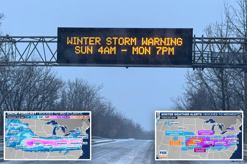
A significant winter storm, the first of its magnitude this year, is sweeping across a vast 2,100-mile stretch of the United States, impacting regions from the Northwest and Plains to the Mid-Atlantic and East Coast. This expansive weather system is bringing with it a multitude of hazardous conditions, including heavy snowfall, near-blizzard conditions, and crippling ice accumulations, which pose significant threats to life and property. Major metropolitan areas are bracing for the impact, with concerns about extended power outages due to the heavy ice expected to accumulate on power lines and trees.
The storm’s journey began on the West Coast, even spawning California’s first tornado of the year, before moving through the northern Rockies and central Plains. Early impacts were felt in Wichita, Kansas, where freezing drizzle coated roadways in ice, leading to numerous accidents and prompting authorities to urge residents to stay home. Interstate 70 in Kansas experienced closures due to a series of crashes, straining law enforcement resources. Over 64 million residents are under winter weather alerts, including Winter Storm Warnings and Ice Storm Warnings, with the most significant impacts anticipated between Interstates 50 and 70.
Blizzard Warnings have been issued for dozens of counties in Kansas and Missouri, including Salina and Wichita, anticipating visibility dropping to less than a quarter-mile due to blowing snow and winds gusting up to 50 mph. This marks the first Blizzard Warning in several years for parts of the Wichita and Kansas City metropolitan areas. South of the heavy snow band, a significant ice threat looms, with accumulations of up to an inch predicted from southern Missouri through Kentucky and into West Virginia. This heavy glaze is expected to cause widespread power outages, with the mountainous terrain potentially prolonging restoration efforts. Following the storm, arctic air will plunge a large portion of the northern US below freezing for several days, adding further hardship for those unprepared.
This winter storm is anticipated to be the most significant snowfall event of the season so far, with some areas potentially experiencing their largest snowfall in over a decade. Snowfall totals are projected to approach a foot in Kansas, Missouri, Illinois, Ohio, and parts of West Virginia. Even higher accumulations are possible in the Appalachians and along the Great Lakes due to terrain influences. Many municipalities in the storm’s path have declared snow emergencies, mobilizing crews for around-the-clock snow removal and road treatment. Major interstates, including I-70 and I-44, are expected to become impassable in some areas due to the heavy snow and ice.
Major cities like St. Louis, Louisville, and Lexington are forecast to receive between 5 and 8 inches of snow, with higher amounts possible around Indianapolis and Kansas City. The snowfall is expected to reach even further east, impacting Philadelphia and Washington, D.C., with potential accumulations of 3-6 inches. Widespread school closures are anticipated across the affected regions. South of the heavy snow band, a significant ice storm is developing, with hours of freezing rain anticipated. Ice accumulations of at least a half-inch are predicted in parts of southern Missouri, southern Illinois, and the Appalachians, posing a serious threat to power infrastructure and trees.
The combination of heavy ice and strong winds is expected to cause widespread power outages. The weight of the ice on tree limbs, combined with the wind, will likely lead to broken branches falling on power lines. Kansas City International Airport (MCI) experienced temporary closures due to ice accumulation on the airfield, though operations resumed after treatment. The Kansas City Chiefs’ departure for their game in Denver was also delayed due to a combination of mechanical issues and weather conditions. Major airlines are offering travel waivers to passengers impacted by the storm, however, this hasn’t prevented long lines and numerous delays and cancellations. Unlike previous winter weather events this season, warmer temperatures are not expected to follow this storm, meaning the accumulated snow and ice will likely remain for an extended period, prolonging the impacts.
While the northern US grapples with winter conditions, the South faces a different threat: severe thunderstorms. A Level 3 out of 5 risk for severe storms has been issued for parts of northern Louisiana, western Mississippi, and southeastern Arkansas. A Level 2 risk extends from East Texas to far western Alabama. These storms are anticipated to bring gusty winds and the potential for tornadoes. This severe weather threat impacts regions recently affected by a tornado outbreak in late December, raising concerns about further damage. Severe thunderstorms are not uncommon in the South during the winter months, as the region is in its tornado season. The confluence of these severe weather events across the country highlights the wide-ranging impact of this powerful winter storm.


