Late Summer Waterspout Spectacle Graces the Great Lakes
A fascinating natural phenomenon unfolded across the Great Lakes region recently, as a Canadian cold front triggered an impressive display of nearly 100 waterspouts over a five-day period. From August 24 to 28, weather enthusiasts and lakeside residents were treated to the sight of these tornado-like columns of swirling air and water, creating a spectacle that highlights the unique meteorological conditions of late summer in the region. According to data from the International Centre for Waterspout Research (ICWR), Lake Erie claimed the majority of these sightings with 49 waterspouts, while Lake Ontario followed with 26 observations. The phenomenon wasn’t limited to these two lakes, however, as Lake Huron reported 14 sightings, Lake Michigan saw seven, and even Ontario’s Georgian Bay registered a single waterspout during this active period. This clustering of waterspouts represents one of the more significant outbreaks of the season, though it falls well short of the record-setting day in October 2023 when Lake Erie alone hosted an astonishing 188 waterspouts in a 24-hour period.
For those unfamiliar with the phenomenon, waterspouts represent nature’s aquatic version of a tornado, though typically with less destructive potential. These fascinating weather events form when a significant temperature contrast develops in the lower atmosphere, particularly when cool air masses move over relatively warm lake waters. Late summer and early autumn create ideal conditions for waterspout formation across the Great Lakes, as the first waves of cool Canadian air encounter lake surfaces that have been warming throughout the summer months. This temperature differential creates atmospheric instability, which can lead to the formation of these rotating columns of air and water mist. Unlike their more dangerous tornado cousins that form over land, waterspouts generally remain less intense and tend to dissipate quickly if they move onshore, limiting their threat to coastal communities.
The recent outbreak began when a notably cool air mass descended from Canada, bringing autumn-like temperatures to the region despite the calendar still showing late August. This unseasonable coolness provided the perfect setup for waterspout formation as it moved over lakes that retained their summer warmth. The temperature contrast between the cool air and warm water created the instability needed to trigger these fascinating weather phenomena. For meteorologists and weather enthusiasts, this period offered an exceptional opportunity to observe and document multiple waterspouts, sometimes occurring simultaneously across different parts of the same lake. Many residents along the shores of these lakes were able to witness this relatively rare sight, with some capturing photographs and videos that quickly spread across social media and weather observation networks.
While waterspouts create a dramatic visual display, the National Weather Service emphasizes that they primarily pose risks to boaters and those engaged in water activities rather than to onlookers on shore. These rotating columns can generate strong, gusty winds and choppy waters that could potentially capsize smaller vessels caught in their path. Most waterspouts during this outbreak remained over open water, following the typical pattern where they form, persist briefly, and then dissipate without making landfall. Weather authorities always advise boaters to maintain a safe distance from waterspouts and to head to shore if conditions appear favorable for their formation. For lakeside communities, these events generally represent more of a fascinating meteorological curiosity than a significant hazard, though proper caution is always warranted when unusual weather phenomena occur.
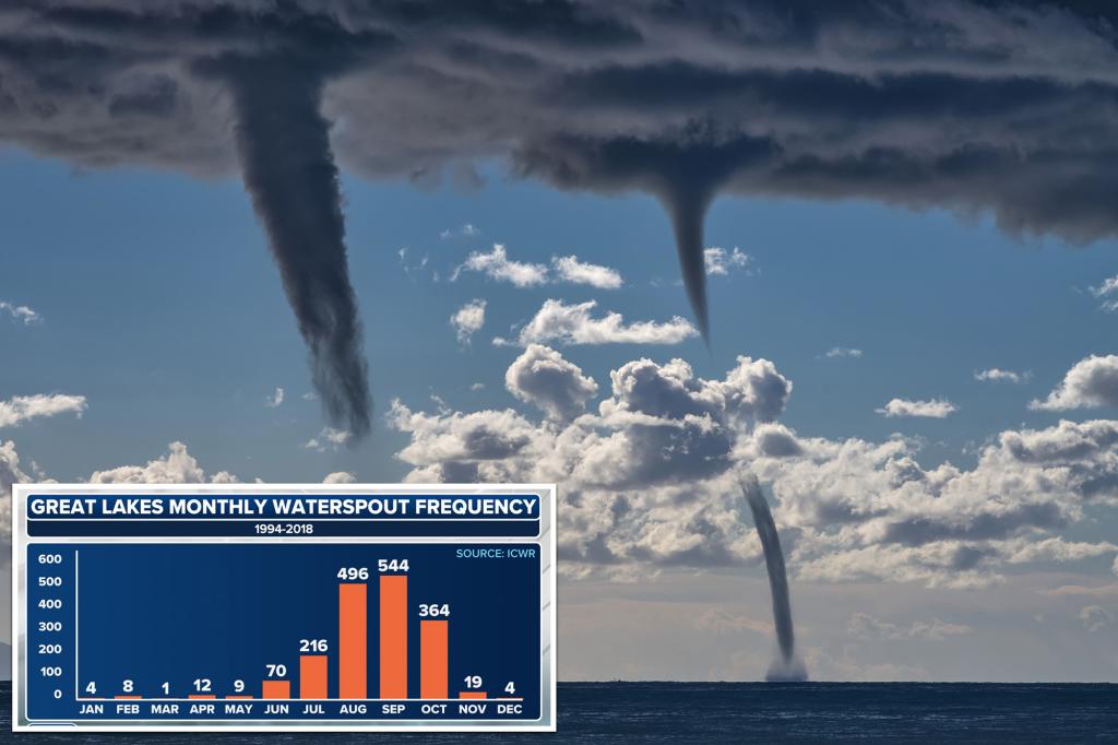
The timing of this waterspout outbreak aligns perfectly with what meteorologists consider the peak of “waterspout season” across the Great Lakes region. This period typically runs from late August through October, when the seasonal transition brings increasing opportunities for cool air masses to interact with still-warm lake waters. The temperature differential during these transitional months creates ideal conditions for waterspout formation, making it the most likely time to observe these weather phenomena. The contrast between cooling air temperatures and warm lake surfaces not only contributes to waterspout development but also plays a role in the region’s characteristic lake-effect precipitation. As similar conditions develop throughout autumn, the possibility remains for additional waterspout activity before the lakes cool significantly with the approach of winter.
While impressive in its scope, this recent outbreak of waterspouts serves as a reminder of the diverse and sometimes spectacular weather phenomena that characterize the Great Lakes region. The nearly 100 sightings over five days represent a significant weather event but still fall well short of the record-setting day in October 2023, when Lake Erie alone hosted 188 waterspouts in a single 24-hour period. This comparison highlights how variable these outbreaks can be, depending on specific atmospheric conditions and timing. As climate patterns continue to evolve, researchers at organizations like the ICWR closely monitor these events to better understand their formation, frequency, and potential impacts on the region. For residents of the Great Lakes states and provinces, waterspouts remain one of nature’s more impressive displays—beautiful to observe from a safe distance while serving as a harbinger of the seasonal transition from summer warmth to autumn coolness that defines this unique ecological region.


