



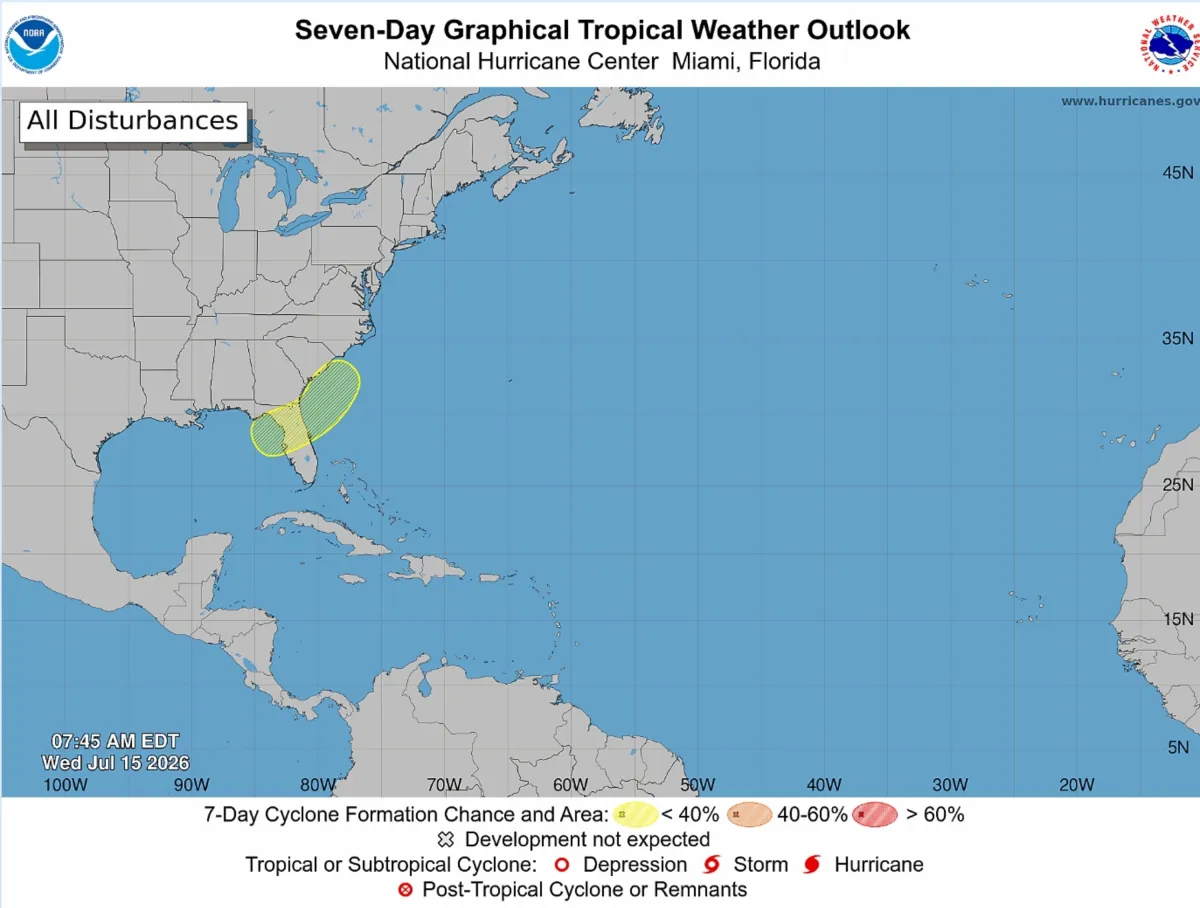
Florida residents are keeping a watchful eye on the skies this week as meteorologists track a developing weather system in the northeastern Gulf of Mexico. This area of low pressure is forecast to drift northeastward directly across the Florida peninsula before heading toward the southeastern U.S. coast early next week. While the National Hurricane Center (NHC) currently gives the disturbance a modest 20 percent chance of tropical development over the next seven days, forecasters warn that even an unorganized system has the potential to disrupt weekend plans with heavy downpours, localized flooding, and dangerous coastal conditions.
If the system manages to organize and find its footing over the warm Gulf waters, it could overcome dry air and wind shear to become Tropical Storm Bertha, the second named storm of the 2026 Atlantic hurricane season. This follows Tropical Storm Arthur, which brought heavy rain to Texas back in June. Regardless of whether it officially earns a name, the system is expected to behave like a classic tropical disturbance, dragging a massive plume of deep tropical moisture across the state. In addition to torrential rainfall, meteorologists are warning of dangerous rip currents along the beaches of Florida, Georgia, and the Carolinas, with the potential for strong winds and storm surge if the system strengthens rapidly.
Local meteorologists across the Sunshine State are urging residents to prepare for a very wet weekend, particularly in major metro areas. Experts in the region note that cities like Tampa, Orlando, and Daytona Beach are squarely within the impact zone, with widespread storms, sudden downpours, and gusty winds projected for Saturday and Sunday. While some areas are in need of rain, meteorologists caution that this won’t necessarily be a uniform drought-buster, but rather a series of heavy, on-and-off downpours that could spill over into the middle of next week. Early rainfall models suggest a bullseye of 4 to 6 inches along Florida’s Gulf Coast, with a widespread 3 inches expected further inland, meaning urban flooding in low-lying areas remains a distinct possibility.
What makes this system particularly interesting to meteorologists is its origin. Unlike the massive historical hurricanes that travel thousands of miles across the Atlantic from the coast of Africa, this disturbance is a classic example of a “homegrown” tropical threat. These systems typically form close to the U.S. coastline when a slow-moving weather front stalls over the warm waters of the Gulf of Mexico or the nearshore Atlantic. Because homegrown storms develop so close to populated landmasses, they offer significantly less warning time than their long-track counterparts, making it crucial for coastal residents to monitor local forecasts closely as conditions can change overnight.
This local threat is unfolding during a hurricane season that federal forecasters initially predicted would be quieter than average, largely due to the presence of El Niño conditions in the Pacific. In its preseason outlook, the National Oceanic and Atmospheric Administration (NOAA) projected a below-normal season with eight to 14 named storms, three to six of which could become hurricanes, and only one to three reaching major Category 3 status or stronger. El Niño typically creates strong upper-level wind shear across the Atlantic basin, which acts like a ceiling that shreds developing tropical systems before they can organize. However, weather experts are quick to remind the public that it only takes one storm hitting a vulnerable area to cause a disaster, regardless of how quiet the seasonal forecast looks on paper.
Because the low-pressure system is still in its infancy, significant uncertainty remains regarding its exact track and ultimate intensity. In the coming days, minor shifts in where the storm’s center actually forms could drastically alter which communities receive the heaviest rain and strongest winds. For now, the general consensus points to a soggy week ahead for North and Central Florida before the system pushes out into the Atlantic. Emergency management officials and weather experts advise residents throughout the Southeast to enjoy their outdoor plans while they can, but to keep their umbrellas handy and continue monitoring local weather updates as this homegrown system takes shape.